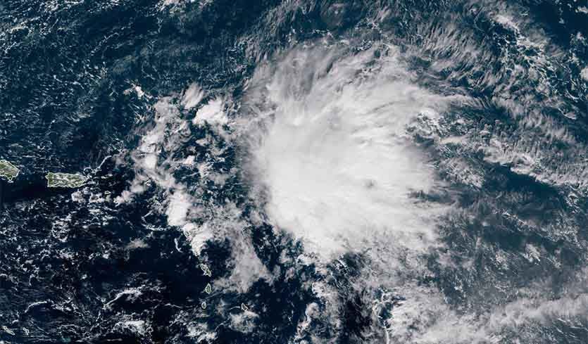
| Above: Visible GOES-16 satellite image of 96L at 10:30 am EDT Monday, November 12, 2018. The system was being sheared by strong upper-level winds out of the southwest that were creating about 30 knots of wind shear. Image credit: RAMMB/CSU/CIRA. |
A strong tropical wave (96L) located about 200 miles east of the northern Leeward islands on Monday morning is slowly increasing in organization, and is likely to become the Atlantic’s next tropical depression by Thursday.
Satellite images on Monday morning showed that 96L had a moderate-sized area of heavy thunderstorms that were poorly organized. A pass by the ASCAT satellite from 10:13 am EST Monday showed top winds near 35 mph, and no sign of a surface circulation. The system was headed west to west-northwest at about 8 mph, and was under high wind shear of 30 knots, which was slowing development. Water temperatures were plenty warm for development, near 28 – 28.5°C (82 - 83°F).
Forecast for 96L
The 12Z Monday run of the SHIPS model predicted that shear would slowly fall over the next few days, reaching the moderate range, 10 - 20 knots, on Wednesday and Thursday. Water temperatures will remain warm those days, likely allowing 96L to develop into a tropical depression or tropical storm. 96L has had strong support for development from the GFS model and its ensemble members, but weak support from our other top models for predicting tropical cyclone genesis, the European and UKMET. The system is expected to move mostly west-northwest at about 10 – 15 mph through Wednesday, passing just north of the Leeward Islands, Virgin Islands, Puerto Rico, and Hispaniola. Due to strong upper-level winds out of the southwest that will be affecting 96L during this period, most of the system’s heavy thunderstorms will be displaced to the northeast, keeping rainfall amounts generally below two inches over the islands.
By Thursday, 96L will be near the Turks and Caicos Islands and southeast Bahamas, and heavier rains may occur on those islands, since the system will likely by a tropical depression or tropical storm then. By Friday, 96L is expected to turn to the north in response to a trough of low pressure passing to its north, and Bermuda may receive heavy rains from 96L on Friday or Saturday. Wind shear will increase significantly as 96L heads north, causing the system to weaken as it makes its closest approach to Bermuda. 96L is not expected to be a threat to the continental U.S. In their 7 am EST Monday Tropical Weather Outlook, NHC gave 96L 2-day and 5-day odds of development of 50% and 90%, respectively. The next name on the Atlantic list of storms is Patty--the 16th name on the list.


