| Above: Infrared image of Invest 99L off the coast of Africa, as seen at 9:05 am EDT Friday, September 21, 2018.. Image credit: Levi Cowan, tropicaltidbits.com. |
A tropical wave that emerged from the coast of Africa on Thursday night has been designated 99L by the National Hurricane Center (NHC). This wave is a threat to develop into tropical depression early next week, and may pose a danger to the Lesser Antilles Islands as early as Wednesday night.
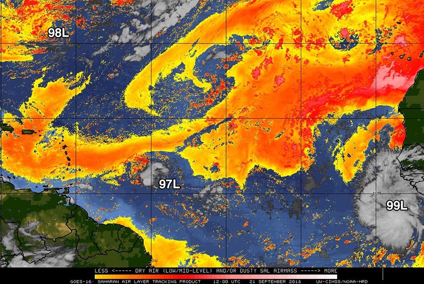
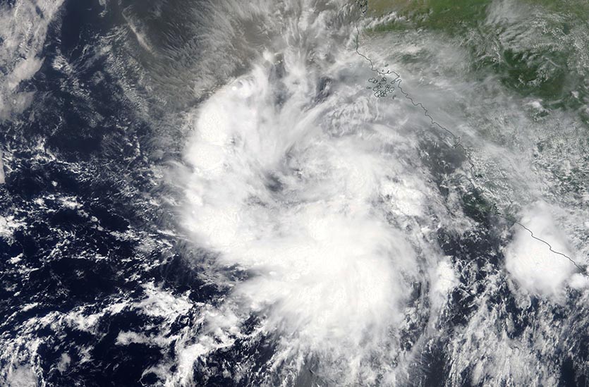
99L was located about 600 miles southeast of the Cabo Verde Islands at 8 am EDT Friday, and was headed west at about 15 - 20 mph. Conditions were favorable for development, with sea surface temperatures (SSTs) near 26.5 - 27°C (80 - 81°F), a moist atmosphere with a mid-level relative humidity of 65%, and light wind shear of 5 - 10 knots. The dry air of the Saharan Air Layer lay to the northwest, and did not appear to be interfering with development. Satellite images on Friday morning showed that the wave was large and well-organized, with a broad circulation, a moderate amount of heavy thunderstorms, and upper-level outflow on the north side. There was no well-organized surface circulation or low-level spiral bands, though.
 |
| Figure 1. Saharan Air Layer (SAL) analysis for 8 am EDT September 21, 2018. The dry air of the SAL (orange colors) lay well to the northwest of 99L, but was strongly affecting 97L and 98L. Image credit: University of Wisconsin CIMSS. |
99L likely to become a tropical depression by Wednesday
The 12Z Friday run of the SHIPS model predicted that SSTs would remain nearly constant through Sunday, then steadily increase to a very warm 30°C (86°F) by Wednesday. During this time, the atmosphere was predicted to stay moist, and wind shear light. These conditions should allow 99L to develop into a tropical depression by Tuesday or Wednesday, though development may be slowed by 99L's fast forward speed (near 20 mph) and rather low latitude (near 9 - 10°N). Only one of the operational 0Z Friday runs of our top three models for predicting tropical cyclone development--the UKMET model--predicted development of 99L into a tropical depression early next week. However, 99L had support for development from about 30% of the 50 members of the 0Z Friday European model forecast, and over 50% of the 20 members of the 0Z Friday GFS ensemble forecasts.
99L is moving rapidly, and is expected to maintain a forward speed near 20 mph for the next week. This fast forward motion could bring 99L into the Lesser Antilles Islands as early as Wednesday night, though an arrival on Thursday is more likely. In their 8 am EDT Friday Tropical Weather Outlook, NHC gave 99L 2-day and 5-day odds of development of 20% and 60%, respectively. The next two names on the list of Atlantic storms are Kirk and Leslie.
 |
| Figure 2: MODIS image of Invest 99L off the coast of Africa, as seen on Friday morning, September 21, 2018. Image credit: NASA Worldview. |
A portion of Florence’s remains could develop next week
The Friday morning runs of our top three models for predicting tropical cyclone genesis—the European, GFS, and UKMET models—all predicted that a portion of Florence's remnants would feed a non-tropical surface low pressure system expected to close off on Saturday in the Central Atlantic near 35°N, 45°W, between Bermuda and the Azores Islands. SSTs are unusually warm in this region, about 25 - 26°C (77 -79°F), which is more than 1°C above average. The low will get cut off from the jet stream and meander in an area of weak steering currents for many days. If the system works its way to the southeast, as recent model runs have suggested, it will find warmer ocean temperatures and moderate wind shear. In their 8 am EDT Friday Tropical Weather Outlook, NHC gave this system 2-day and 5-day odds of development of 10% and 70%, respectively.
98L near Bermuda no immediate threat
Another portion of Florence’s remnants formed a non-tropical low pressure system that was located just southeast of Bermuda on Friday morning. This system (98L) has lost all of its heavy thunderstorms, and high wind shear and dry air should keep any development slow. The low is expected to move to the southwest of Bermuda by early next week, and could loop back to the northwest and bring rain to the Southeast U.S. as early as Tuesday. In their 8 am EDT Friday Tropical Weather Outlook, NHC gave 98L 2-day and 5-day odds of development of 10% and 20%, respectively.
97L approaching Lesser Antilles: 10% chance of development
A tropical wave located about 600 miles east of the Lesser Antilles Islands on Friday morning (97L) was moving west-northwest at 10 mph. Satellite imagery on Friday morning showed 97L had developed a surface circulation, but was nearly devoid of heavy thunderstorms. High wind shear and dry air should prevent development. In their 8 am EDT Friday Tropical Weather Outlook, NHC gave this system 2-day and 5-day odds of development of 10%.
We'll have a new post later today, "Japan’s Typhoon Jebi Demonstrates the Vulnerability of Airports to Storm Surge".


