| Above: Tropical Cyclone Trevor approaches landfall in Australia's Queensland state as seen in this MODIS image taken on Tuesday morning, March 19, 2019. Image credit: NASA. |
After an impressive bout of rapid intensification that saw its winds increase by 65 mph in just 24 hours, Tropical Cyclone Trevor made landfall in northeast Australia’s Queensland state near 07 UTC Tuesday (5 pm Tuesday local time) as a Category 3 storm with 115 mph winds, according to the Joint Typhoon Warning Center (JTWC). Trevor is the first major tropical cyclone to hit Queensland since Nathan of 2015, which struck the state as a Category 3 storm with 115 mph winds on March 19, 2015; Queensland was also struck by Category 4 Marcia on February 19, 2015, which caused nearly $600 million in damage.
Wind gusts of 117 km/hr recorded at #LockhartRiver as severe tropical #cycloneTrevor crosses the coast. Radar images at: https://t.co/ghLHHp4H1f pic.twitter.com/SjS8fzraN1
— Bureau of Meteorology, Queensland (@BOM_Qld) March 19, 2019
Trevor made landfall just south of the town of Lockhart River (population 600), where wind gusts of up to 73 mph (117 km/hr ) were measured. Lockhart River was on the less intense side of Trevor’s clockwise circulation. The cyclone caused considerable damage to trees and a few buildings, and up to 400 mm (15.75”) of rain are expected along its path across the sparsely populated Cape York Peninsula through Wednesday.
Japan's #Himawari8 satellite watched as Tropical Cyclone #Trevor made landfall over the Cape York Peninsula in northern Queensland, Australia. After crossing the peninsula, Trevor is expected to restrengthen in the Gulf of Carpentaria. More: https://t.co/zGNLrUyLIC pic.twitter.com/cGg228XDN7
— NOAA Satellites (@NOAASatellites) March 19, 2019
Trevor’s second landfall could be stronger than its first
Trevor will weaken as it slogs across the cape over the course of about 24 hours, but another landfall—perhaps another intense one—appears quite possible after Trevor enters and traverses the Gulf of Carpentaria between Wednesday and Friday. SSTs are extremely warm in the gulf, running around 30-32°C (86-90°F)—up to 1°C above average for this time of year—and the water has a high heat content, in excess of 100 kilojoules per square centimeter. Wind shear will remain very light, less than 10 knots. All of these conditions are favorable for intensification, but it will take some time for Trevor to re-organize after it finishes its trek over the Cape York Peninsula.
 |
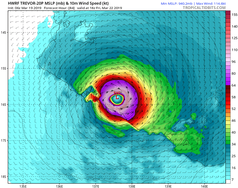
| Figure 1. Predicted surface winds (colors) at 18Z (2 pm EDT) Friday, March 22, 2019, from the 6Z Tuesday run of the HWRF model. The model predicted that Tropical Cyclone Trevor would be a Category 4 storm with 130-mph sustained winds, approaching landfall along the sparsely populated shore of Australia’s Gulf of Carpentaria. Image credit: tropicaltidbits.com. |
The last several runs of the HWRF model are in agreement that Trevor will reach Category 4 intensity before its second landfall on the northeast coast of Australia’s Northern Territory around Saturday local time (Friday afternoon U.S. EDT). There are no sizable coastal towns in this sparsely settled area, where the Aboriginal population is widely dispersed in small communities.
A rough analogue to the projected dual landfalls of Trevor occurred in April 2006, when Tropical Cyclone Monica struck just south of Lockhart River with 100-mph sustained winds (according to JTWC) and then intensified dramatically across the Gulf of Carpentaria. Monica’s central pressure reached 916 mb, and peak 1-minute winds just before landfall were estimated at 180 mph by JTWC, the strongest on record for any Australian cyclone. Property damage was minimal, owing to the small population, but some 140 million trees were reportedly damaged or destroyed.
Bob Henson contributed to this post.


