| Above: GOES-16 visible satellite image of Post-Tropical Cyclone Chris as of 1500Z (11 am EDT) Thursday, July 12, 2018. The storm was headed for Newfoundland, outlined at top right. Image credit: RAMMB / CIRA @ CSU. |
Fast-weakening ex-Hurricane Chris was hustling toward Newfoundland on Thursday. Chris was downgraded to a tropical storm and then to a post-tropical cyclone on Thursday morning after peaking at Category 2 strength late Tuesday. As of 11 am EDT, Chris was located about 275 miles southwest of Cape Race, Newfoundland. Chris’s top sustained winds had dropped to 70 mph, and the storm was rapidly losing tropical characteristics over chilly North Atlantic waters as it merged with a frontal zone while racing northeast at about 36 mph.
The center of Chris was predicted to pass over or near the Avalon Peninsula of Newfoundland, which includes the provincial capital of St. John’s, on Thursday evening. Heavy rains were already sweeping across Newfoundland as Chris approached. Isolated amounts of up to 6” are possible, and widespread totals of 1-3” are expected, with wind gusts of up to 60 mph. Sable Island recorded 2.87” of rain in the 6 hours ending at 8 am EDT Thursday, with rainfall rates of up to 1.2" per hour. The anemometer stopped transmitting data at 8:47 am EDT after recording sustained winds of 40 mph, gusting to 51 mph.
Southeast Canada is no stranger to ex-hurricanes, or actual hurricanes, that are recurving toward the northeast. Back in 2010, Hurricane Igor blasted across southeast Newfoundland on an approach roughly similar to Chris’s, while still classified as a Category 1 hurricane. Igor (which had earlier peaked as a Category 4 storm) made landfall with 85-mph winds and dumped up to 10” of rain in eastern Newfoundland. The storm’s high winds and heavy rains caused $200 million CAD in damage across Newfoundland and prompted the name Igor to be retired.
 |
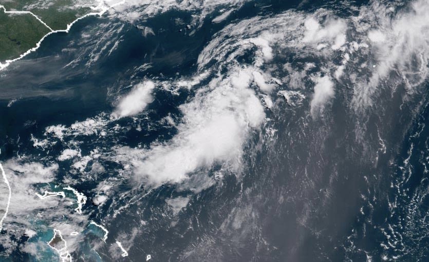
| Figure 1. Visible satellite image of ex-Hurricane Beryl at 11:15 am EDT July 12, 2018. Ex-Beryl was generating disorganized heavy thunderstorms between The Bahamas and Bermuda. Note the large area of African dust to the east of ex-Beryl being drawn northwards into the circulation of Post-Tropical Cyclone Chris, which was located beyond the upper right corner of this image. Image credit: NOAA/RAMMB. |
Beryl's remnants: still disorganized
Satellite images early on Thursday afternoon showed that Beryl's remnants were bringing sparse and disorganized heavy thunderstorms to the waters between The Bahamas and Bermuda, with no signs of a surface circulation trying to form. Ex-Beryl brought 2.03” (52 mm) of rain to Freeport in The Bahamas in the 24 hours ending at 8 am EDT Thursday, and 3.11” (79 mm) to Nassau in the 12 hours ending at 8 pm EDT Wednesday. There are no hurricane hunter missions scheduled for Thursday or Friday into the system.
Beryl’s remains are expected to move northeastward at about 10 mph Thursday through Sunday. The SHIPS model predicts that wind shear will be a moderate to high 15 - 25 knots during that period, and ex-Beryl will mostly be over the warm waters of the Gulf Stream, where SSTs will be near 26 - 28°C (79 - 82°F). These conditions are somewhat favorable for development, and the 0Z Thursday runs of our top models for predicting tropical cyclone genesis—the European, GFS, and UKMET models—all predicted some weak re-development of ex-Beryl by Friday night, when the system is predicted to be in the waters between Massachusetts and Bermuda. In their 8 am EDT Thursday Tropical Weather Outlook, the National Hurricane Center gave ex-Beryl 2-day and 5-day odds of regeneration of 10% and 50%, respectively.
Dr. Jeff Masters wrote the Beryl section of this post.


