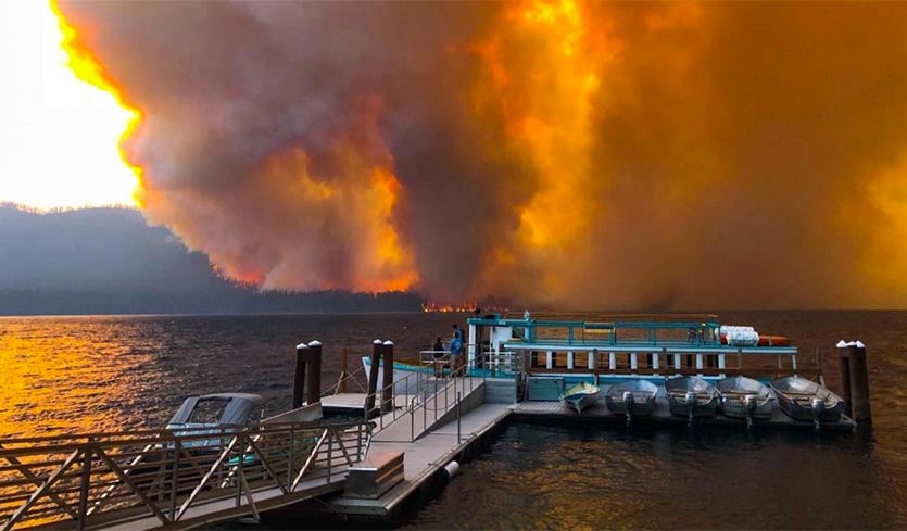
| Above: Gary Schid posted this photo on Facebook of the Howe Ridge Fire taken from the shore of Lake McDonald in Montana's Glacier National Park on August 13, 2018. Image credit: Gary Schid. |
A lightning storm touched off multiple fires in Montana’s Glacier National Park on Saturday, and on Sunday, strong winds fanned one of those fires into a blaze that forced evacuations in the most heavily-trafficked area of the park. The National Park Service said the 25-site Sprague Creek campground was evacuated on Monday, a day after the fast-moving Howe Ridge Fire forced the evacuation of 82 rooms at the historic Lake McDonald Lodge. A second campground with 87 sites and some private residences also have been evacuated. A portion of the Going-to-the-Sun-Road remained closed to traffic. The fire has destroyed an unknown number of structures around Lake McDonald, and had burned over 2500 acres as of Tuesday morning. This is the second year in a row that wildfires have caused evacuations around Lake McDonald; a blaze in 2017 closed Going-to-the-Sun Road for weeks and destroyed the Sperry Chalet, an iconic backcountry lodge built in 1914.
 |
| Figure 1. All smoke, no clouds: a river of smoke extends at sunset from Oregon into Montana in this 9:52 pm EDT August 13 true-color GOES-16 image from the College of DuPage. Smoke from fires burning in Glacier National Park can be seen at upper right, and black dots on the left side of the image are the shadows of the big Northwest U.S. volcanoes projected onto the smoke layer below them. |
Fire danger in the park has been unusually high this summer due to moderate drought and near-record heat. Glacier National Park hit 100°F on August 11, its first 100-degree day since record keeping began in 1948. The National Weather Service in Missoula, Montana, which is southwest of the park, says the area has not received measurable rainfall for 40 days as of Monday.
 |
| Figure 2. Yosemite’s iconic Half Dome lies shrouded in wildfire smoke in this webcam view taken at 9:23 am PDT August 14, 2018; Image credit: Yosemite Conservancy. |
Yosemite reopens
Yosemite Valley in Yosemite National Park reopened at 9 am PDT August 14, after being evacuated on August 3 due to the Ferguson Fire. Thanks to slightly cooler weather, light winds, and increased humidity, firefighters have been able to gain the upper hand on the fire, which was 86% contained by 7 am PDT August 14. Full containment is expected on August 15, after 34 days of effort. The 97,000-acre fire has killed two people and injured nineteen. This summer’s closure of Yosemite was the most extensive closure of the park since 1997, when flooding forced a two-month closure.
The fire has brought very unhealthy levels of fine particulate pollution (PM2.5, particles less than 2.5 microns or 0.0001 inch in diameter) to the park since mid-July. Air pollution levels were still high in Yosemite on Tuesday morning, measuring 58 – 78 μg/m3--an Air Quality Index (AQI) in the red (“Unhealthy”) range. The EPA 24-hour standard for PM2.5 is 35 μg/m3. A July 2018 paper by Colorado State's Bonne Ford and co-authors estimated that PM2.5 from wildfire smoke contributed to 17,000 premature air pollution deaths each year in the U.S. in the year 2000. This number was expected to rise to 44,000 deaths per year by the year 2100, if we follow a “business-as-usual” approach to climate change, which would lead to an increase in U.S. wildfires.
 |
| Figure 3. The Air Quality Index (AQI) was in the “unhealthy” range (red) across much of Northwest U.S. and southwestern Canada due to wildfire smoke at 1 pm PDT Tuesday, August 14, 2018. At two monitors in central Washington, the AQI was in the “hazardous” (maroon) range. Image credit: EPA/AirNOW. |
California fires kills a sixth firefighter
According to the National Interagency Fire Center, on August 14 there were 106 active large fires in the U.S., which had collectively burned over 1.8 million acres. The Mendocino Complex—the largest fire in California history, at 354,000 acres—claimed the life of a Utah firefighter yesterday, the sixth firefighter to die in California’s 2018 fires. The Mendocino Complex is actually made up of two fires being fought in parallel: firefighters achieved 100% containment on August 13 on the smaller River Fire portion (49,000 acres), and 68% containment of the larger Ranch Fire portion (305,000 acres).
The Carr Fire, located in northern California near the town of Redding, is the sixth most destructive fire in California history, and has left eight people dead, including three firefighters. At 7 am PDT August 14, the fire was 65% contained and had burned 207,000 acres, making it the eighth largest fire in California history. The fire was started when a flat tire on a vehicle caused the wheel's rim to scrape against the pavement, creating sparks.
 |
| Figure 4. Predicted surface PM2.5 concentrations (in μg/m3) at 7 pm EDT August 14, 2018, from the 2 am EDT August 14 run of the experimental HRRR-Smoke model. Pollution levels in excess of the EPA standard of 35 μg/m3 (orange colors) are expected over much of the Northwest U.S. HRRR-Smoke is a very promising model that combines the increasingly skillful HRRR weather model with the physics of smoke generation, advection, and radiative effects. The model is increasingly being used by the National Weather Service and air quality agencies. Image credit: NOAA/Earth System Research Laboratory. |
Fire/smoke outlook for the next week and beyond
Temperatures will be a bit less blazingly hot over the western U.S. over the next couple of days—in part because of the sun-blocking effect of the extensive smoke—but the heat will begin to return by late week. There is no sign of any widespread rain to help quench the fires and reduce the persistent pollution. If there is any good news, it’s that the NOAA/NWS Storm Prediction Center is not highlighting any areas of critical or extremely critical fire-weather risk in their Tuesday-morning outlook.
Toward the weekend, a cool front will boost the odds of showers and thunderstorms across the northern Rockies. These are often a mixed blessing across fire country, as they typically drop little rainfall but bring the risk of lightning and gusty winds that can spark and fan new blazes. Early next week could see a reprise of scorching heat across the West and Northwest, perhaps extending all the way to Seattle and Portland.
Smoke aerosol from #BCWildfires #Canada crossing #AtlanticOcean to reach #Ireland & #UnitedKingdom early hours Wednesday in latest #Copernicus Atmosphere Monitoring Service forecast https://t.co/G3ulNmvsGq @MetEireann @EPAIreland @metoffice @bbcweather @simon_sat pic.twitter.com/CbqeIaue7L
— Mark Parrington (@m_parrington) August 14, 2018
There’s no getting around the worrisome aspects of the longer-term outlook through early autumn. Fire season typically peaks in late summer over the Northwest and in autumn across California, so we have many weeks of vigilance left to go. There will still be the risk for pockets of extreme fire weather, especially if temperatures continue to skew above average. The most recent Significant Wildland Fire Potential Outlook produced by the National Interagency Fire Center projects an above-normal risk of wildfire across all of Idaho, Washington, and Oregon, and most of California and Nevada, through the month of August.
Bob Henson co-wrote this post.


