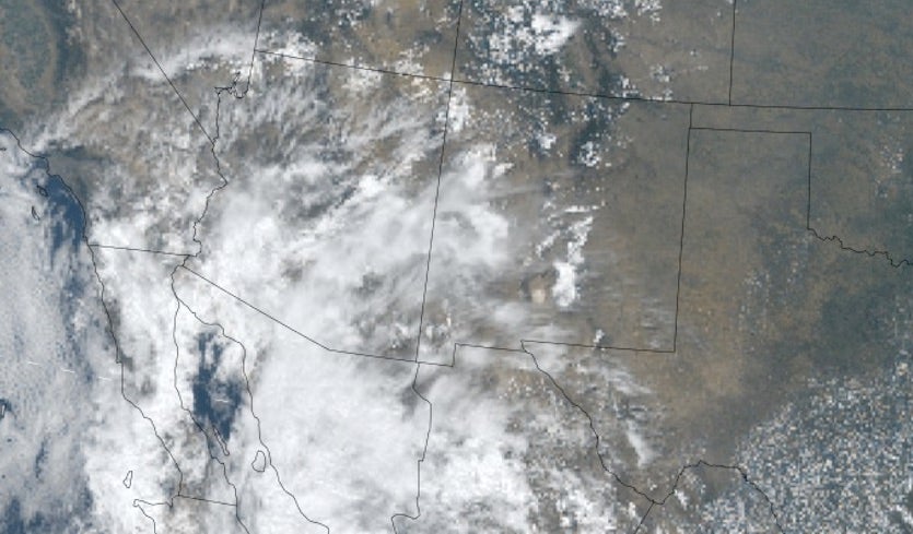
| Above: Deep moisture from Tropical Depression Bud was streaming across the Southwest U.S. as shown in this visible satellite image from 1833Z (2:33 pm EDT) Friday, June 15, 2018. Image credit: NCAR/RAL. |
Pockets of torrential rain will douse the western and central U.S. over the next few days, a result of the remnants of ex-Hurricane Bud and a slug of Caribbean moisture. The wet pattern—unusually early for the Desert Southwest—will be more scattershot than uniform, but flash flooding is a distinct possibility wherever the heaviest rains happen to set up.
Bud was a fast-weakening tropical depression at 8 AM PDT Friday, centered in the southern Gulf of California and moving north at 12 mph. A large shield of moisture was already working its way across northwest Mexico into southern Arizona, and the remnants of Bud will shunt more moisture into the Desert Southwest on Friday night into Saturday. A radiosonde launched on Friday morning from Tucson found 3.37 centimeters (1.33”) of precipitable water (PW), the amount of moisture in a vertical column above a given spot. PW values could top 1.5” in the Phoenix area by Friday night, which would be a record for so early in the warm season.
East Pacific tropical cyclones often haul moisture into the Southwest during the late summer, but it’s very unusual for this to happen in mid-June. A 2009 study in Monthly Weather Review led by Kristen Corbosiero (now at SUNY-Albany) examined all cases from 1958 to 2003 in which an East Pacific cyclone triggered rains in the Southwest. These cases included a total of more than 130 rainy days across the 56-year period—but none of those days occurred any earlier than August, and the most likely time for such events by far was September. One recent counterexample that occurred after the study period was 2015’s Hurricane Blanca, the earliest named storm on record to strike Baja California, which made landfall as a weak tropical storm on June 8 after attaining Category 4 status. Blanca’s remnants dropped 0.19” of rain in Phoenix and 0.31” in Yuma, giving that city its heaviest June rain in more than a century.
The NWS/Phoenix office is predicting 0.25-0.50” in the Phoenix area as Bud’s remnants sweep through during the weekend. Since records began in 1895, there have only been ten cases where Phoenix saw at least 0.25" of rain during the entire month of June. Only four Junes in Phoenix have topped 0.50", the most recent being 1972. As much as an inch is predicted near Tucson, where June rains tend to be a bit more generous.
 |
| Figure 1. Storm-total rainfall from the remnants of Hurricane Bud across southern Arizona as predicted early Friday morning, June 15, 2018. Image credit: NWS/Phoenix. |
Carlotta develops off Mexico’s southwest coast
The third named storm in this year’s active East Pacific season was christened by the National Hurricane Center at 11 AM PDT Friday. Located about 60 miles south-southeast of Acapulco, Tropical Storm Carlotta was drifting northeast at 5 mph with top sustained winds at 40 mph. Carlotta won’t have much time to strengthen before it slogs into the Mexican coast on Saturday just south of Acapulco, but some intensification is possible prior to landfall. Heavy rains extend well to the southeast of Carlotta’s circulation, and localized amounts from this slow-moving system could easily top 10”, so flash floods and landslides will be the main threat from Carlotta.
As noted by weather.com, Carlotta is the second earliest development on record of the East Pacific’s fourth tropical cyclone (including a tropical depression that preceded Aletta, Bud, and Carlotta). Only 1974’s Dolores beat Carlotta to the punch, and that was by just six hours.
 |
| Figure 2. Infrared satellite image of Tropical Storm Carlotta, just off the southwest coast of Mexico (left), and showers and thunderstorms associated with a tropical wave near the Yucatan Peninsula (right) as of 1815Z (2:15 pm EDT) Friday, June 15, 2018. The remnants of Bud are visible at far upper left. Image credit: NASA/MSFC Earth Science Office. |
A soggy tropical wave heads for Texas
Thunderstorms continued to flare up Friday off the coast of Yucatan in association with a tropical wave moving slowly to the northwest. In its tropical weather outlook issued at 2 PM EDT Friday, NHC gave this system only a very slight chance (10%) of developing into a tropical depression over the next two to five days as it drifts toward the Texas coast. Regardless of whether or not it develops, the wave could bring heavy rains into southern Texas early next week. People in southeast Texas are understandably nervous about any forecast of heavy rain given the scars left by catastrophic Hurricane Harvey last year. The most likely outcome at this point is that the approaching wave will lead to a period of stronger and more widespread showers and thunderstorms moving inland from the coast. Assuming that the wave does not develop into a tropical cyclone, coastal sections of Texas are most likely to see 2-5” of rain through early next week, with perhaps a few heavier totals topping 5” as the wave eventually moves inland. These amounts are obviously far less than the widespread 30-40”+ totals produced by Harvey.
Moisture from both Bud and the tropical wave heading for Texas will flow toward the Rockies and Great Plains, leading to the potential for localized flash flooding across a wide area. Wildfire scars are a particular concern in such setups, as water can flow much more quickly over land that’s been recently burned. Officials will be closely monitoring areas around the 416 Fire in southwest Colorado and the Badger Fire in far southern Wyoming. Forecast models are also suggesting that 2-5” of rain is possible this weekend as thunderstorms regenerate and “train” along a stationary front extending from South Dakota across southern Minnesota into Wisconsin.
 |
| Figure 3. Precipitation forecast issued on Friday morning for the 5-day period from 8 am EDT Friday, June 15, 2018, through Wednesday, June 20. Image credit: NOAA/NWS/WPC. |


