| Above: Kansai International Airport on September 4, 2018, after Typhoon Jebi's storm surge inundated one runway and flooded Terminal 1. Image credit: Kentaro Ikushima/Mainichi Newspaper via AP. |
In a stunning demonstration of the destructive potential of typhoon storm surge—and the human propensity to under-engineer infrastructure designed to withstand the worst nature has to offer—Japan’s third busiest airport, Kansai International Airport in Osaka Bay, was inundated by Category 2 Typhoon Jebi’s storm surge on September 4, 2018. The surge flooded one runway, closing it for ten days, and damaged electrical facilities in one of the airport’s two terminals, forcing its closure for seventeen days. The airport was fully open today for the first time since the disaster. The last time a typhoon of similar size and strength hit Osaka Bay was in 1961: Typhoon Nancy, which made landfall as a Category 2 storm with 100 mph winds.
関西空港 全体を閉鎖
— NHKニュース (@nhk_news) September 4, 2018
滑走路が浸水する様子(早送り映像)https://t.co/jsU7mTMHQU #nhk_news pic.twitter.com/In5r5m4Agv
According to storm surge expert Dr. Nobuhito Mori of Kyoto University, Jebi brought the highest storm surge on record to Osaka Bay: 2.8 meters (9.2 feet). The peak surge occurred near the time of high tide, bringing a total storm tide of 3.29 meters (10.8 feet), breaking the previous record of 2.93 meters (9.6 feet). A damage survey released on September 21 found that even higher water levels of over 5 meters (16.4 feet) occurred in some portions of Osaka Harbor, when the influence of the waves on top of the surge was included (see Google Earth .kml file here).
Typhoon Jebi—a former Category 5 super typhoon—struck Japan’s main island of Honshu near Osaka near noon local time on September 4. The Joint Typhoon Warning center rated Jebi as a Category 1 storm with sustained 1-minute winds of 85 mph just before landfall, but the Japan Meteorological Agency (JMA) rated Jebi as being much stronger: 100 mph sustained 10-minute winds, equivalent to a high-end Category 2 storm. Winds measured at land stations supported at least a Category 2 storm, and a JMA spokesperson said Jebi was the strongest typhoon to strike Honshu in 25 years.
 |
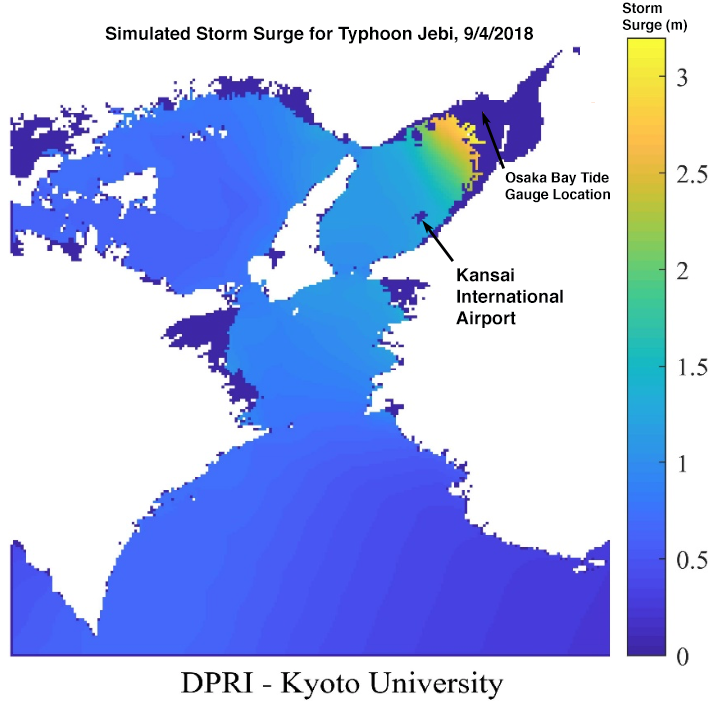
| Figure 1. Simulated maximum storm surge for Typhoon Jebi in Osaka Bay, September 4, 2018. A storm surge of approximately 1.5 meters (4.9 feet) affected Kansai International Airport. The high tide brought an additional 0.5 meters of water to the airport. This simulation does not account for the additional storm surge caused by large waves (wave set-up), nor the inundation caused by large waves on top of the surge. Image credit: Dr. Nobuhito Mori of Kyoto University. |
Jebi took a worst-case track for generating a record storm surge in Osaka Bay: the eye passed along the west side of the bay, and the powerful right-front eyewall winds pushed a large storm surge into the bay’s shallow waters. Kansai International Airport, located on the east side of the bay, likely received a storm surge of about 1.5 meters (4.9 feet), with the high tide bringing an additional 0.5 meters of water, for a total storm tide of about 2 meters (6.6 feet), according to a storm surge simulation run by Dr. Mori. It’s possible the surge was higher than that, as the post-storm damage survey found water levels up to 3.03 meters (10 feet) above normal on the mainland where the connecting bridge to the airport ends. Breaking waves on top of the surge (not included in Dr. Mori's model) probably contributed another 0.5 meters of surge. The airport, which lies on an artificial island constructed at a cost of $20 billion, two miles from shore, was designed to handle a storm surge of up to 3.7 meters (12 feet).
 |
| Figure 2. Simulated wave height for Typhoon Jebi in Osaka Bay, September 4, 2018. Wave heights of up to 3 meters (10 feet) likely affected Kansai International Airport. Image credit: Dr. Nobuhito Mori of Kyoto University. |
Dr. Mori theorizes that large waves on top of the surge, which he simulated to be up to 3 meters in height (10 feet), broke over the airport’s sea wall and flooded most of the artificial island. The powerful typhoon also hurled a large freighter into the 2-mile-long bridge connecting the island to the mainland, severing half of the lanes of the only access road to the airport.
Typhoon Jebi Swept Across Japan's Main Island of Honshu, Leaving At Least 6 Dead and a Path of Destruction in Its Wake.
— ~Marietta️ (@MariettaPosts) September 4, 2018
Jebi Is The Strongest Typhoon to Make Landfall in Japan Since 1993.
Prayers For Japan #TyphoonJebipic.twitter.com/YKjXHbJYEF
Other airports are vulnerable to storm surge flooding
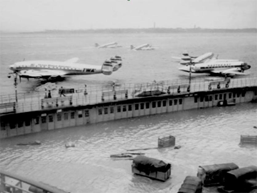
Osaka’s Kansai airport is not the only major airport to suffer serious flooding from a storm surge. On November 25, 1950, the storm surge from a powerful nor’easter flooded the runways of New York’s LaGuardia Airport, which lie at elevations as low as 6.7 feet above the high tide mark. In 2012, Hurricane Sandy’s brought more severe flooding to LaGuardia, submerging portions of the 7,000-foot long east-west runway and damaging lighting and navigation systems. The floodwaters created a surreal scene where jetways ended in the rippling water, as if King Triton was beckoning travelers to journey to his kingdom. In the wake of Hurricane Sandy, LaGuardia was given nearly $40 million to install flood barriers and gravity drains, replace back-up generators, and revamp the airport’s power monitoring and control system.
 |
| Figure 3. LaGuardia Airport in New York City after the storm surge from the November 25, 1950 nor’easter flooded the runways. |
According to a Climate Central article, the region's two other major airports also experienced storm-surge flooding--though less severe--during Hurricane Sandy. John F. Kennedy International Airport saw flooding from a storm surge that rose out of Jamaica Bay. Newark (N.J.) International Airport was hit by a storm surge that flowed through New York Harbor and into Newark Bay, flooding the eastern sections of the busy international gateway, and parts of the neighboring port, where waters reached 4 feet above ground level. Runways at New Jersey’s Teterboro Airport were also inundated during Hurricane Sandy, and the Regional Planning Association recommended in June that Teterboro Airport be permanently closed because of its long-term vulnerability to sea level rise. "The cost of maintaining Teterboro, both financially and environmentally, will be increasingly hard to justify with rising sea levels, and should eventually result in closing the airport," the association said in its report. "Over the next 20 to 30 years the airport will slowly start to lose its battle with sea-level rise and will need to be replaced." The cost of replacing the airport was estimated to be $50.8 billion over 40 years.
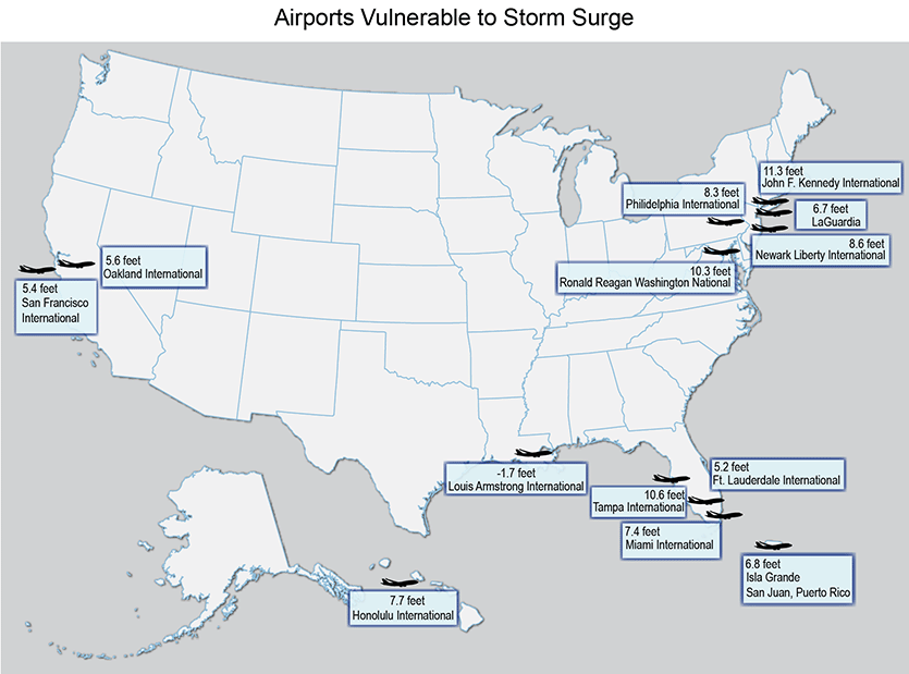
Ten other major U.S. airports outside the New York City area have at least one runway with an elevation within 12 feet of current sea levels, according to the National Climate Assessment (Figure 4). These airports are vulnerable to flooding from a moderate to high storm surge. A number of airports in major Asian cities also lie at low elevation in typhoon storm surge zones, including those in Shanghai, Tianjin, Shenzhen, and Seoul, as detailed in a September 5 article from Bloomberg. And though storm surge from tropical cyclones is not an issue in Europe, some airports there are as risk of storm surge inundation from winter storms; according to a report published by the European air traffic management group Eurocontrol, “in the medium- to longer-term, sea-level rise could threaten runway capacity at more than 30 European airports.”
 |
| Figure 4. According to the National Climate Assessment, 13 of the 47 largest airports in the U.S. have at least one runway with an elevation within 12 feet of current sea levels, and are vulnerable to flooding from a moderate to high storm surge. |
Climate change will increase storm surge inundation of airports
As sea level rises due to human-caused climate change in coming decades, there will be a notable increase in frequency of airports being flooded by storm surges—particularly if there is a sharp increase in the frequency and intensity of the strongest hurricanes and typhoons, as predicted by theory and computer modeling. The problem may be particularly acute for Japan, Korea, and northeastern China, since the latitude where western North Pacific typhoons reach their peak intensity has migrated poleward over the past 70 years. In a 2016 paper by University of Wisconsin hurricane scientist Jim Kossin, Past and Projected Changes in Western North Pacific Tropical Cyclone Exposure (updated in 2018), it states "...the past poleward migration in the Western North Pacific has coincided with decreased tropical cyclone exposure in the region of the Philippine and South China Seas, including the Marianas, the Philippines, Vietnam, and southern China, and increased exposure in the region of the East China Sea, including Japan and its Ryukyu Islands, the Korea Peninsula, and parts of eastern China." A poleward migration of where typhoons reach their peak intensity is an expected result of global warming. A June 2018 study of the locations where hurricane and typhoon eyes form also found a poleward shift, "thus expanding the area at risk of tropical cyclone-related damage", the authors wrote.
Ironically, Kansai International Airport’s website states: “The construction of water barriers around the entire airport island was completed in 2006. This effectively eliminated rising water levels on the island even in the event of abnormal tides and typhoon surges. In fact, this solution eliminated problems affecting airport functions irrespective of sea level increases due to prolonged global warming and long-term ground settlement.”


