| Above: Enhanced infrared satellite image of Tropical Cyclone Vayu at 1700Z (1 pm EDT) Tuesday, June 11, 2019. Image credit: UW-CIMSS. |
Gathering steam over the warm waters west of India, Tropical Cyclone Vayu will approach the coast of far western India and Pakistan later this week on an uncommon and potentially serious track.
As of 12Z Tuesday, the Joint Typhoon Warning Center placed the center of Vayu about 250 miles southwest of Mumbai, India. Vayu was packing top sustained one-minute winds of minimal Cat 1 strength (75 mph) and moving almost due north at 9 mph. Little change in motion is expected through at least Wednesday afternoon EDT.
Vayu’s core of showers and thunderstorms (convection) was healthy but not especially large on Tuesday afternoon. However, the cyclone already had a sprawling circulation, with tropical-storm-force winds extending as far out as to 125 miles to the southeast. These winds rotating around Vayu appears to working in tandem with the normal southwesterly monsoon flow. Together, the flows will push ample moisture toward the west coast of India and spawn heavy coastal rains.
Forecast for Vayu
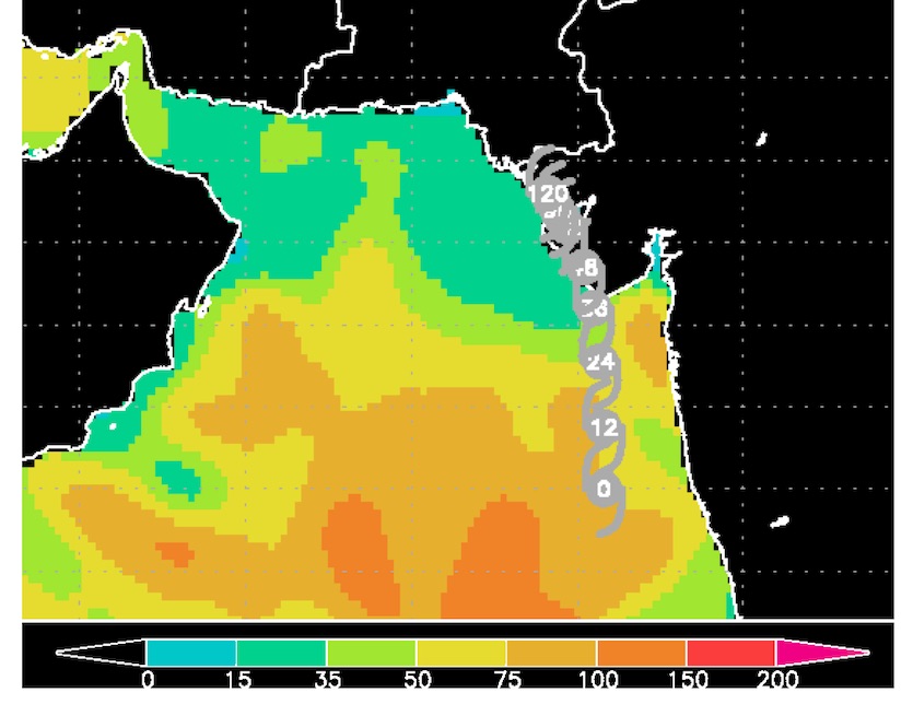
Vayu is well positioned to intensify, with ample warm water (sea surface temperatures of 30-31°C or 86-88°F) along its path. The storm is embedded in a large field of moisture with mid-level relative humidity of around 80%. Moderate to strong shear of 15-25 knots may impede Vayu’s intensification somewhat, although the shear is projected to weaken on Thursday.
The 06Z and 12Z Tuesday runs of the high-resolution HWRF model—among the top models for predicting hurricane intensity in the Atlantic—brings Vayu up to Category 3 strength by the time it nears the coast of India’s Gujarat state early Thursday EDT. The global-scale GFS and European models support the idea that Vayu will be at least a Cat 2 equivalent by Thursday.
The Indian Meteorological Department, which has primary responsibility for Vayu forecasts, predicted in its 1730 IST advisory that Vayu would reach the Gujarat coast between Porbandar and Mahuva as a severe cyclonic storm early on Thursday local time, with top sustained winds around minimal hurricane strength (60-65 knots). The IMD warned of a potential storm surge of 1.0-1.5 meters (3.3 to 4.9 feet) along parts of the Gujarat coast. The agency also noted that the Madden-Julian Oscillation was in a favorable phase to support convection in the Arabian Sea, including Vayu.
 |
| Figure 1. Oceanic heat content (OHC) along the projected path of Tropical Cyclone Vayu as of 12Z Tuesday, June 11, 2019. Through Wednesday, Vayu will remain atop OHC values of greater than 50 joules per square meter, which would support the possibility of rapid intensification. Image credit: RAMMB/CIRA/CSU. |
The most challenging part of the Vayu forecast is how the storm will behave after it nears the far western coast of India on Thursday. Steering currents are predicted to be very weak from Thursday onward, and it appears Vayu is likely to move very slowly along the coast of Gujarat state from Thursday into Friday, perhaps just offshore or just inland. Such a track could reduce the landfall impacts but prolong and broaden the storm’s overall effects, including torrential rains of 10” or more near the center. By Friday or Saturday, the storm may be nearing the southeast coast of Pakistan, where it could affect Karachi, the world’s sixth biggest city (population around 15 million).
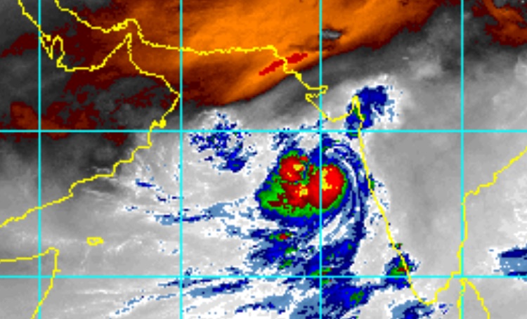
Eventually, Vayu’s anticipated crawl on or near the coast would lead to weakening over far western India and/or Pakistan. Dry air from the South Asian content will infiltrate Vayu's circulation over time, adding to the eventual weakening. It is possible the storm will stay far enough offshore to maintain its strength and then angle west without making landfall. This is a low-probability scenario, though.
 |
| Figure 2. Enhanced infrared image of Tropical Cyclone Vayu west of India as of 1815Z (2:15 pm EDT) Tuesday, June 11, 2019. The bright orange area at top depicts dry air that is increasingly likely to be ingested into Vayu’s circulation as the storm moves north. Image credit: RAMMB/CIRA/CSU. |
Cyclone history of far western India and southeast Pakistan
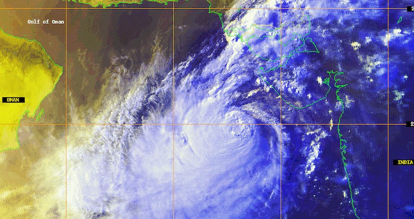
Weak tropical cyclones are not uncommon in far western India, but only a handful of Category 2 or stronger equivalents have made landfall in the last few decades. Of the two most recent high-impact landfalls in this area, the first occurred in 1998, when a Category 3 equivalent came ashore on a recurving track that moved head-on across the Gujarat coast near Porbandar on June 10. The near-perpendicular approach contributed to a storm surge of around 5 meters (16 feet).
The 1998 Gujarat cyclone took at least 1063 lives, and relief workers estimated that 10,000 to 14,000 people were missing and likely killed, according to a summary by tropical weather analyst Gary Padgett. Many of those who died were reportedly involved with coastal salt harvesting and did not know of the storm’s approach.
 |
| Figure 3. Satellite image of the 1998 Gujarat cyclone at 1210Z on June 8, 1998. Image credit: NOAA. |
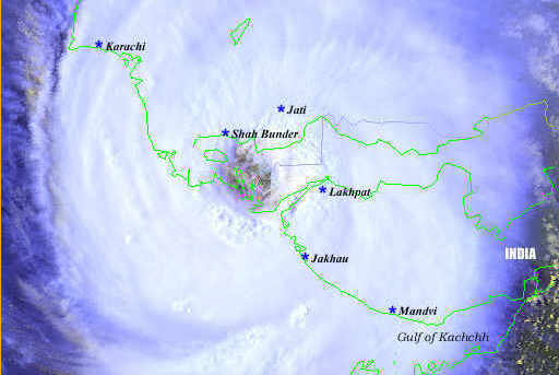
In May 1999, an even stronger cyclone, peaking at high-end Cat 3 strength, followed a very similar track displaced a bit to the northwest. The cyclone made landfall on May 20 in far southeast Pakistan about 70 miles southeast of Karachi. This put the city on the storm's weaker northwest side (winds in Karachi were only 44 mph), while the cyclone dumped heavy rains and lashed parts of extreme southern Pakistan and far western India with high winds and storm surge.
 |
| Figure 4. Satellite image of the 1999 Pakistan cyclone at 1027Z on May 20, 1999. Image credit: NOAA. |
Only one death was reported in India from the May 1999 cyclone. In Pakistan, 400 bodies were recovered, and the national government reported that some 5800 other people were missing and presumed killed. “Although the Pakistani government had issued warnings for this storm, no large-scale evacuations were ordered,” said NOAA’s Hurricane Research Division in a 15th anniversary retrospective on this cyclone.


