| Above: Downed trees and power lines block Main Street South in Bridgewater, Conn., after severe storms rolled through the area Tuesday, May 15, 2018. Image credit: John Woike/Hartford Courant via AP. |
At least five deaths were reported on Tuesday in the northeast U.S. from a fierce onslaught of thunderstorm-related high winds, giant hail, flooding rains, and possibly at least one tornado. The most damaging complex of storms moved across the densely forested, highly populated region from northeast Pennsylvania into western Connecticut, including the lower Hudson Valley of New York. Some 600,000 customers across the Northeast lost power at the height of the storms, according to poweroutage.us.
All of the storm-related deaths were reportedly due to trees falling onto cars, reported weather.com.
Complete evolution of today’s severe weather event in the Northeast on #GOES16 IR pic.twitter.com/YuVIqvlVIv
— Sam Lillo (@splillo) May 15, 2018
The NOAA/NWS Storm Prediction Center’s log of preliminary storm reports for Tuesday included more than 300 reports of high wind from the Northeast storms. As was the case on Monday, the event met the definition of a derecho—a long-lived swath of damaging straight-line winds produced by thunderstorms—as put forth in a 2005 study by Walker Ashley and Thomas Mote.
According to weather.com’s Jon Erdman and Brian Donegan, the wind swaths on Monday and Tuesday both exceeded the 400-kilometer (248-mile) wind criterion put forth by Ashley and Mote, as well as a more stringent 650-km (404-mile) criterion from a definition proposed by NWS scientists in a 2016 paper.
Tuesday's storm threw the New York area’s transportation network into chaos. As trees fell onto railways, three lines of the Metro-North commuter rail system were shut down during the Tuesday evening rush hour. Thousands of people were stranded at Grand Central Station for hours in a scene that verged on the surreal for long-time commuters.
If you wanted to see the chaos that an announcement like "All train service in and out of Grand Central is delayed indefinitely" causes #NYC #GrandCentral @MetroNorth pic.twitter.com/uUNVGHqEDy
— Andrew Katz (@KatzAndrewS) May 15, 2018
Giant hail set a possible state record in Connecticut
Several discrete supercell storms swept from west to east across the area before the storms morphed into a powerful wind-packing squall line (or mesoscale convective system). A trained spotter reported one tornado near Yulan, New York, on Tuesday afternoon. National Weather Service meteorologists were canvassing the storm-hit areas of New York and Connecticut on Wednesday to see if this or any other tornadoes could be confirmed.
The SPC log of preliminary hail reports for Tuesday included two reports of baseball-sized hail (2.75” in diameter), one at Harford, Pennsylvania, and the other near Clermont, New York, as well as 2.5”-diameter reports near Frederick, Maryland, and Granby, Connecticut. WU weather historian Chris Burt recently compiled a list of all official and unofficial state-level hailstone size records. If confirmed, the 2.5”-wide hailstone at Granby, CT, would tie the state’s unofficial record for largest hailstone, which occurred at Hamden, CT, on July 10, 1989.
The unofficial state records held firm in New York (4.0” in Otsego County on Aug. 16, 1951), Pennsylvania (5.5” at Meadville on June 26, 1950), and Maryland (4.0” at Annapolis on June 22, 1915).
Huge hail for this area at TSP overlook in southern Columbia Co. @NWSAlbany pic.twitter.com/kZCgLJOuBk
— Julian Diamond (@juliancd38) May 15, 2018
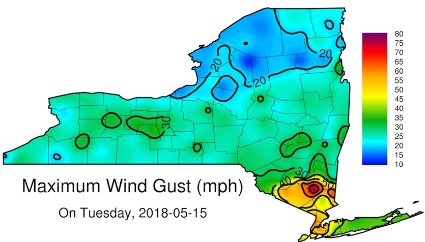
The New York State Mesonet, a statewide network of high-quality weather stations, experienced the strongest thunderstorm-related wind gust since its 2015 founding with a 3-second gust to 77.5 mph at Beacon, NY—about 40 miles north of Manhattan on the Hudson River—between 4:15 and 4:20 pm EDT. Peak gusts from the mesonet in New York City included 59.0 mph in the Bronx, 57.1 mph in Queens, and 55.6 mph in Manhattan, all around 5 pm EDT.
The mesonet’s state record for any weather event was set just last week, on May 4, with a non-thunderstorm-related gust to 79.6 mph at Malone in extreme northern New York.
 |
| Figure 1. Peak wind gusts recorded by the New York State Mesonet on Tuesday, May 15, 2018. Nearly all of far southeast New York experienced wind gusts ranging from 40 to more than 75 mph. Image credit: NYS Mesonet. |
| Figure 2. Weather observations collected at five-minute intervals from the New York State Mesonet station at Beacon, NY, on Tuesday, May 15, 2018. The peak wind gust recorded at a standard anemometer height of 9 meters (about 30 feet) was 77.5 mph, which occurred between 4:15 and 4:20 pm. The arrival of the severe thunderstorm also brought a steep temperature drop at the 9-meter instrument height—from 86°F at 4:15 pm EDT to 57°F at 4:30 pm. Image credit: NYS Mesonet. |
| Video 1. Several trees were knocked down by thunderstorm winds gusting up to 77.5 mph at Beacon, NY. Here’s a “now you see the trees, now you don’t” video collected by a webcam at the New York State Mesonet site at Beacon. Look carefully! Image credit: NYS Mesonet. |
As the high winds pushed offshore, they were enough to generate a meteotsunami—a brief enhancement of tides caused by a weather feature—along the coast from Delaware to southern New England. Water levels rose and fell in pulses on the order of a few inches each during a period of several hours. Angela Fritz has more at Capital Weather Gang.
On the whole, this is still a relatively quiet storm season
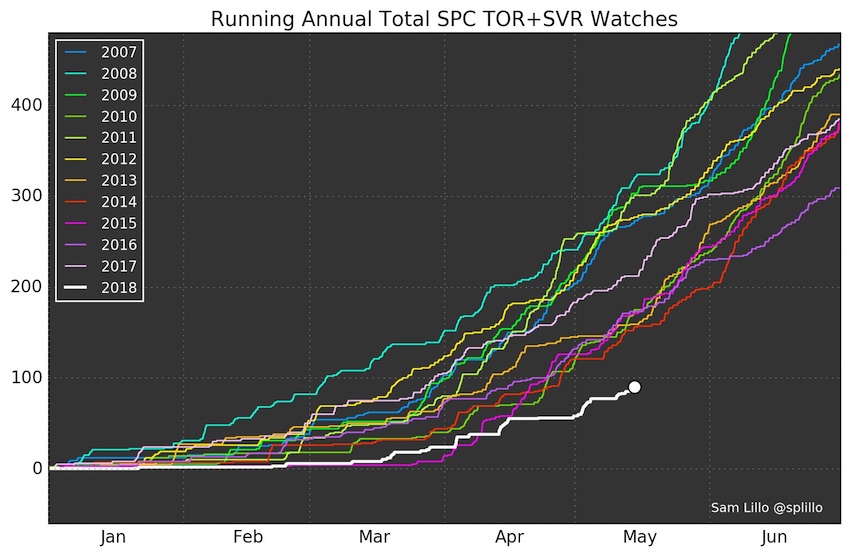
If it feels like many parts of the U.S. have gone almost directly from late winter to early summer, there’s good reason. Last month was among the coldest Aprils on record for large parts of the central and eastern U.S., while May has seen a weak jet stream and recurrent swaths of warm, humid air. Both situations have been less than favorable for widespread severe weather outbreaks.
 |
| Figure 3. As of Monday, May 14, this year has seen the fewest tornado and severe thunderstorm watches issued by the NOAA/NWS Storm Prediction Center up to this point for any year since at least 2007. Image credit: Sam Lillo (University of Oklahoma), @splillo. |
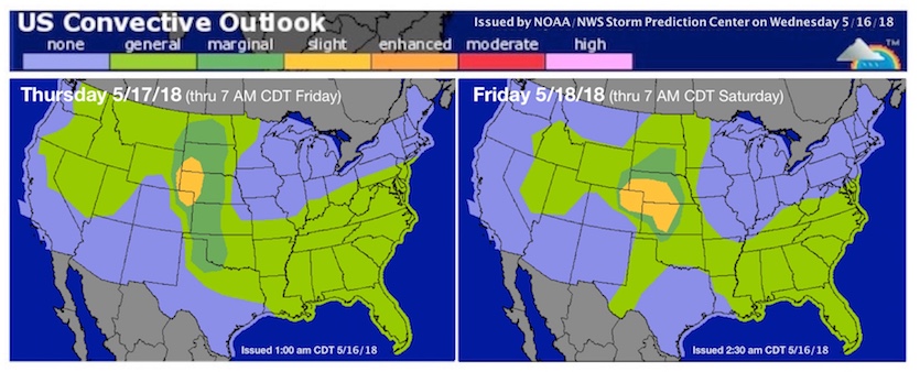
Upper-level winds will remain anemic by mid-spring standards for at least the next week across the normally storm-prone Great Plains and Midwest. The most focused chance of severe weather appears to be across the Central High Plains on Thursday and Friday, which are under Day 2 and 3 slight-risk areas as of Wednesday morning. Widespread, high-end severe weather is not anticipated, but we can expect a few rotating supercells and scattered reports of severe weather, possibly including tornadoes.
 |
| Figure 4. WU depiction of severe weather risk areas for Days 2 and 3 (Thursday and Friday, May 17 and 18, 2018), as issued by NOAA/NWS/SPC on Wednesday morning, May 16. |


