
| Above: The 30-day period from February 14 through March 15 saw huge contrasts in precipitation across the central U.S., from almost no rain or snow (dark red) over the Southern High Plains to more than 300% above average (light purple) from much of Arkansas into the Great Lakes states. Image credit: NOAA/NWS Advanced Hydrologic Prediction Service. |
Parts of the Ohio and lower Mississippi valleys face a moderate risk of spring flooding, while a swath of intensifying drought from the Southwest into the southern Great Plains may worsen further, according to NOAA’s seasonal outlook released Thursday.
Torrential rains last month smashed all-time February records in Texarkana, Little Rock, and Memphis, with far-above-average rain and snow for the month extending well north into the Great Lakes states (see image at top). The deluge triggered widespread flooding in February, and its impacts may linger into spring. The odds favor wetter-than-average conditions across the Great Lakes and Upper Midwest, which could help raise the flooding potential downstream for the Ohio and lower Mississippi valleys. A number of stretches of the lower Ohio and Mississippi were under flood warnings Thursday. Major flooding was occurring along the Mississippi at Osceola, AR; Vicksburg, MS; and Natchez, MS.
 |
| Figure 1. Spring 2018 flood risk in the contiguous United States. Areas vulnerable to minor flooding are light blue; moderate flooding, medium blue. These maps reflect places where the "background" climate conditions—such as a wet winter and saturated soils—create an enhanced risk of flooding throughout the season. Flash flooding can still occur anywhere in response to extreme weather. Image credit: NOAA Climate.gov map, based on data from the NOAA/NWS Climate Prediction Center (CPC). |
 |
| Figure 2. Floodwaters in the Chickasaw subdivision of Vicksburg, Miss., partially covered street signs on Tuesday, March 13, 2018. Although this area is populated by residents familiar with annual flooding, other subdivisions and some houses in town are now getting flooded. Image credit: AP Photo/Rogelio V. Solis. |
A waning influence from La Niña
“It appears La Niña is on its last legs,” noted Mike Halpert, director of the NOAA/NWS Climate Prediction Center, in an online video accompanying the release. Although NOAA’s La Niña Advisory was continued in the agency’s monthly diagnostic discussion on March 8, the oceanic and atmospheric fingerprints of La Niña are quickly fading. The decline has been goosed in recent weeks by a strong Madden-Julian Oscillation in the equatorial Pacific, where upper-level winds at the 200-millibar level are now mostly from the west and subsurface waters are warming.
The Australian Bureau of Meteorology declared La Niña officially over in the March 13 installment of its biweekly report. The bureau uses a more stringent threshold than NOAA for defining La Niña: sea-surface temperatures in the Niño3.4 region of the tropical Pacific must be at least 0.8°C below average, vs. the NOAA benchmark of 0.5°C below average.
As we discussed in a post last December, the second winter of a La Niña can lead to an enhanced risk of drought over the southern U.S., especially the Southwest and Southern Plains. Events over the last few weeks have fallen in line with this relationship. The fraction of the U.S. covered by severe to exceptional drought (categories D2-D4) has grown from 2.9% in mid-November to 16.3% as of March 13, according to the U.S. Drought Monitor. Most of the Four Corners states, plus Kansas and western Oklahoma and Texas, are now firmly entrenched in severe drought or worse.
 |
| Figure 3. Drought is likely to worsen or develop across much of the Southwest quadrant of the contiguous U.S. this spring. Pockets of drought are predicted to continue in the Southeast and Oregon. Image credit: Map by NOAA Climate.gov, based on data from NOAA/NWS/CPC. |
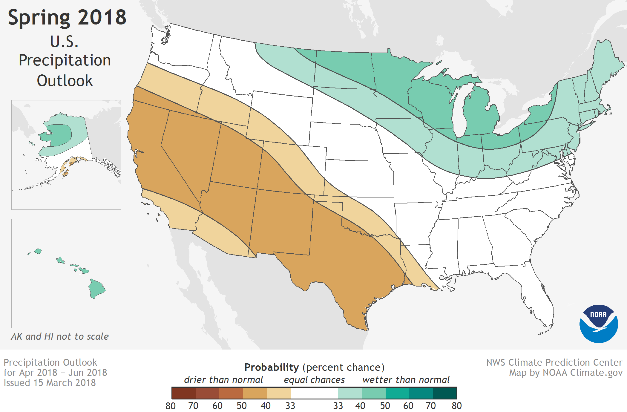
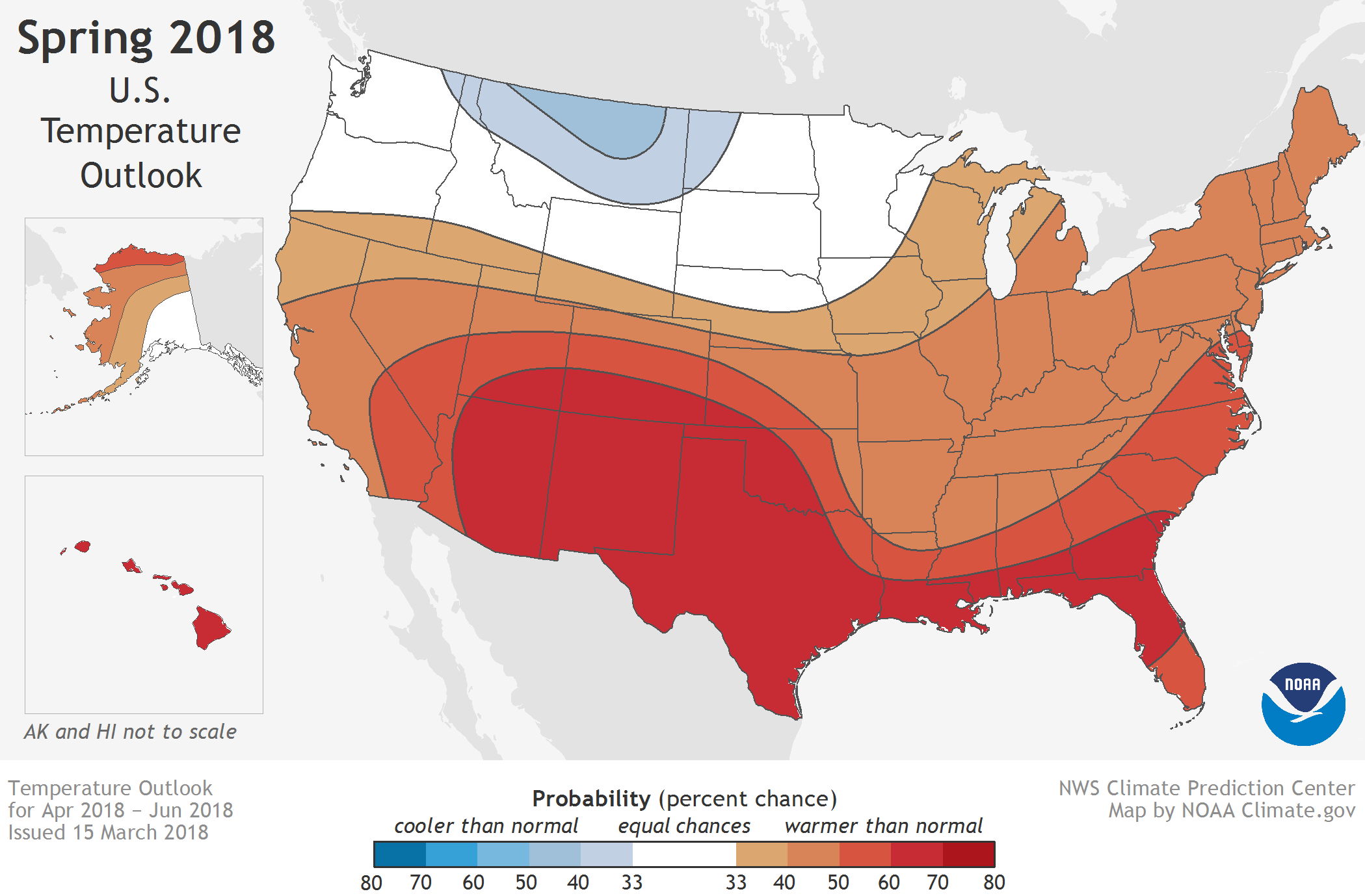
According to NOAA’s outlook, below-average precipitation is favored this spring southwest of a belt from Oregon to Louisiana—roughly the same area that’s been running dry all winter. Any warmer-than-usual temperatures this spring would exacerbate the drought’s impact by increasing the evaporation from soils and vegetation. Unfortunately, that’s just what is expected. Unseasonably warm temperatures are predicted to prevail across all of the nation except Montana and western North Dakota, where moist soils and ample mountain snowpack should help tamp down spring warming.
As noted in NOAA’s long-lead outlook, issued Thursday, “The greatest confidence in the [April-June] 2018 outlook is across the southern tier, where influences from La Niña, overwhelming consistency in dynamical model guidance and statistical tools, long term trends, [and] soil moisture deficits all coincided and favor warmer than normal conditions.”
See our post from March 9 for background on how the departing La Niña and other factors could influence U.S. severe weather this spring.


