| Above: GOES-East visible satellite image of Alberto taken at 10:30 am EDT May 25, 2018. Image credit: NOAA/RAMMB. |
The 2018 Atlantic hurricane season is off to an early start: Subtropical Storm Alberto has formed in the Western Caribbean, along the coast of the Yucatan Peninsula between Belize and Cozumel, Mexico. Satellite loops on Friday morning showed that Alberto had a modest area of heavy thunderstorms to the northeast of its center; these thunderstorms had grown substantially in intensity and areal coverage since Thursday. These thunderstorms are well removed from the center of circulation, something that is characteristic of a subtropical cyclone. Buoy 42056 was located in this area of heavy thunderstorms, and recorded sustained winds near tropical storm-force: 36 mph gusting to 42 mph, at 12:40 am. Waves at the buoy have ranged from 8 to 9.5’ since midnight.
Wind shear over Alberto was a high 25 - 30 knots on Friday morning, which is unfavorable for development. Sea surface temperatures (SSTs) were near 28°C (82°F), which is favorable for development. The atmosphere Alberto was embedded in was quite moist, with a relative humidity at mid-levels of the atmosphere of 70%--also favorable for development. An Air Force hurricane hunter aircraft is scheduled to investigate Alberto on Friday afternoon.
 |
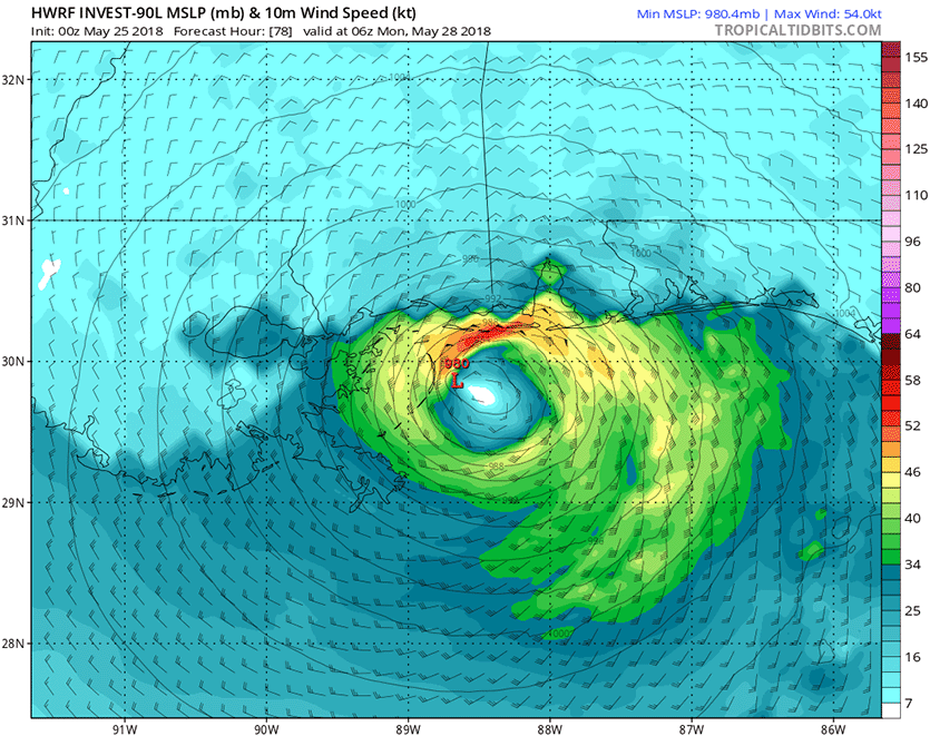
| Figure 1. Predicted wind speed (knots) for Alberto at 6Z Monday, May 28, 2018 (2 am EDT) as predicted by the 0Z Friday, May 25, 2018 run of the HWRF model. The forecast shows Alberto’s tropical storm-force winds (green colors, 34 knots and above) affecting a 200-mile stretch of the Gulf Coast from Southeast Louisiana to Pensacola, Florida. Peak surface winds in this run were about 60 mph. Image credit: Levi Cowan, tropicaltidbits.com |
Alberto a subtropical storm initially
The initial development of Alberto will largely be due to energy provided by an upper level trough of low pressure along the west side of Alberto, not from the warm waters of the ocean, making it a subtropical storm rather than a tropical storm. See my subtropical storm tutorial for more information on the difference between a tropical and subtropical storm. The difference between the two is not important for what is expected to be the main impact of Alberto—heavy rain—but a tropical storm would be more likely to undergo rapid intensification, bringing wind damage concerns.
Wind shear is predicted to slowly fall through the weekend, becoming a moderate 10 – 20 knots Saturday afternoon through Tuesday afternoon (Levi Cowan put together an excellent video discussion last night explaining the reason for this predicted drop in wind shear). This fall in shear should allow Alberto to slowly intensify through the weekend.
Alberto is expected to move slowly north-northeastward at about 5 – 10 mph through the southeastern Gulf of Mexico over the next few days, steered by the flow of a trough of low pressure to its west. By Sunday, this trough is expected to tilt in such a way that the steering currents will push Alberto on more of a north-northwesterly motion. The exact timing of this steering current shift may be important for Alberto’s potential evolution into a fully tropical system, since water temperatures are much cooler near the west coast of Florida--near 25°C (77°F)--but are near 28°C (82°F) in the central Gulf of Mexico. A more westerly track of Alberto will be more likely to allow the system to transition into a fully warm-cored tropical system, resuting in a faster intensification rate.
 |
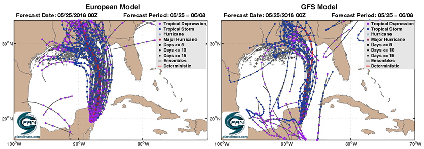
| Figure 2. Predicted tracks of Alberto from the 0Z Friday European model ensemble forecast (left) and 0Z Friday GFS ensemble forecast (right). The purple dots show where the predicted storm is at tropical depression strength, and the blue dots, tropical storm strength. None of the ensemble members predicted that a hurricane-strength storm (light blue dots) would form. Image credit: cfanclimate.com. |
Models in fair agreement
The 0Z and 06Z Friday operational runs of our top four models for predicting tropical cyclone tracks--the European, UKMET, GFS and HWRF models (see my post last Friday on model performance in 2017)--all show Alberto moving north-northeast, then north, then north-northwest, as it traverses the Gulf of Mexico over the weekend. This track will bring the center to a landfall somewhere between Southeast Louisiana and the western Florida Panhandle on Monday. The exact location of Alberto’s landfall is not going to be all that important, since the main impact of the storm will be heavy rain, which will impact this entire stretch of the Gulf Coast regardless of the exact track.
The latest 0Z and 12Z Friday runs of our top intensity models (the HWRF, DSHIPS, LGEM and HMON models) predicted that Alberto would intensify until landfall on Monday morning, with peak winds on Monday morning ranging from 50 mph (LGEM model) to 70 mph (HWRF model). None of the 50 ensemble members of the 0Z Friday European model forecast or the 20 members of the 0Z Friday GFS forecast predicted that Alberto would become a hurricane with 75+ mph winds, but we cannot rule that possibility out, should the storm become fully tropical. The 11 am EDT Friday NHC advisory called for Alberto to peak with 65 mph winds on Monday.
 |
| Figure 3. Predicted precipitation for the 7-day period ending at 8 am EDT Friday, June 1, 2018. Alberto is predicted to bring rainfall amounts of 3 - 5 inches to much of the Southeast U.S. Image credit: National Weather Service. |
Heavy rains the main threat
The counter-clockwise flow of air around Alberto, in combination with a very wet tropical airmass, will funnel large amounts of tropical moisture over Cuba and the Southeast U.S. during the coming week, resulting in very heavy rains. Adding to the rainfall potential will be the likelihood that Alberto will bump into a strong ridge of high pressure to its north early next week, which would block the storm’s progress and result in a slow movement. The latest precipitation guidance from the National Weather Service (Figure 3) shows that 3 – 5” of rain are expected over the next 7 days over much of the Southeast U.S. A storm surge in excess of three feet is likely in Florida's Apalachee Bay from Alberto late Sunday and early Monday.
We’ll have a new post on Alberto by 6 pm EDT. See our post from earlier Friday morning for an update on Cyclone Mekenu, which was nearing a potentially disastrous landfall in Oman as a Category 3 storm.


