| Above: The scence on Interstate 29 in Grand Forks, North Dakota on Tuesday afternoon, Janaury 29, 2019. At the time, Grand Forks had a temperature of -26°F with winds of 28 mph, creating a wind chill of -60°F. Image credit: Sgt. Panasuk, North Dakota Highway Patrol. |
A frigid blast of Arctic air accompanied by powerful winds brought the Midwest U.S. on Wednesday its coldest day in decades, along with near-record low wind chill readings. The most bitter conditions were in Minnesota, where the wind chill plunged to an extraordinary -66°F at Ponsford at 6:18 pm CST Tuesday night. According to the Minnesota State Climatology Office, this is close to the lowest known wind chill ever recorded in the state, a -71F° reading from January 9 – 10, 1982 (though climatologist Brian Brettschneider has documented a possible -72°F wind chill at St. Cloud, MN on January 22, 1936).
 |
| Figure 1. Wind chill readings at 5 am CST Wednesday January 30, 2019. Portions of nine states had extremely dangerous wind chills below -40°F (pink colors). Image credit: NWS. |
On Tuesday, North Dakota also experienced wind chills below -60°F, with the coldest reading a -63°F reading at Grand Forks. According to Brettschneider, North Dakota’s coldest wind chill may be -73°F on January 22, 1936. On Tuesday night, Charles City, Iowa recorded a wind chill of -60°F, not far from the unofficial state record of -64°F documented by Dr. Brettschneider. On Wednesday morning, the wind chill in Menomonie, Wisconsin, bottomed out at -60°F, close to the unofficial state record of -62°F from February 2, 1996. In Sisseton, SD, the wind chill hit -59°F, not far from the unofficial state record of -62°F.
 |
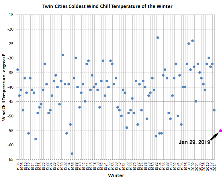
| Figure 2. Wind chill history for Minnesota’s Twin Cities. The lowest wind chill value over the 1905 - 2014 period was -67°F, occurring on January 22, 1936, when the temperature was -34°F with a wind speed of 20 mph. The coldest wind chill this week was -55°F at 11 pm CST Tuesday night January 29, when the temperature was -25°F with northwest winds of 21 mph. Image credit: NWS. |
Real winter in the Windy City
Temperatures dipped to -23°F Wednesday morning at Chicago's O'Hare Airport. This fell short of Chicago’s all-time low of -27°F, but was the first time temperatures dropped below -20°F since Jan. 18, 1994. Chicago’s coldest wind chill on Wednesday was an astounding -52°F. According to the Chicago NWS, this would rank as the city’s fifth coldest wind chill since 1929, and the coldest in 34 years:
1) Jan 10, 1982 -60°F
2) Dec 24, 1983 -59°F
3) Jan 20, 1985 -58°F
4) Jan 17, 1982 -53°F
5) Jan 30, 2019 -52°F
5) Jan 22, 1936 -52°F
7) Jan 9, 1933 -51°F
8) Jan 18, 1994 -50°F
9) Jan 16, 1977 -48°F
9) Jan 18, 1930 -48°F
With a trace of snow recorded on Tuesday, Chicago had its fourteenth consecutive day with snow.
All-time cold high temperatures possible on Wednesday
Wednesday’s Arctic invasion began in earnest on Tuesday night, and for many locations, their high temperature for Wednesday occurred at midnight. Although temperatures were plummeting on Tuesday night, it wasn’t happening quickly enough to produce an all-time record-low daily high for Chicago. The temperature at O’Hare International Airport was –10°F at midnight, and that may end up being the high for the day, as cold air continues to push across the city. The lowest daily maximum on record for Chicago is –11°F, set on Jan. 18, 1994. At 12:55 am Wednesday, O’Hare was already down to –13°F, so the city may have missed setting an all-time record by just one hour.
Several other cities in the region still have a shot at setting their all-time coldest daily high on Wednesday, depending on how much temperatures rise (or don’t rise) during the day. These include:
Moline, IL: current record –12°F (Jan. 18, 1994); –13°F at midnight Tuesday night
Rockford, IL: current record –14°F (Jan. 18, 1994); –16°F at midnight Tuesday night
Madison, WI: current record –15°F (Feb. 9, 1899); –17°F at midnight Tuesday night
Cedar Rapids, IA: current record –14°F (Jan. 18, 1994); –19°F at midnight Tuesday night
La Crosse, WI: current record –17°F (Jan. 4, 1884); –20°F at midnight Tuesday night
Dubuque, IA: current record –15°F (Jan. 18, 1994); –21°F at midnight Tuesday night
No all-time cold records globally set in 2019: an unprecedented occurrence so late in the year
None of the stations in the Midwest with long periods of record appeared to have broken any all-time cold records Wednesday morning. Rockford, IL, came the closest, with the lowest hourly observation at -25°F, just short of their all-time record of -27°F (it is possible they hit -27°F Wednesday morning between hourly observations, though). An NWS COOP observer at Mather, WI, reported -43°F, which ties that station's all-time low from Jan. 30, 1951. Records in Mather go back to 1903.
With another night of extreme cold coming Wednesday night, there are at least four Midwest U.S. cities that have a chance of setting an all-time cold record on Thursday morning: Chicago (predicted low, –25°F, record low, –27°F); Rockford, Illinois (predicted low –31°F, record low –27°F); Cedar Rapids, Iowa (predicted low –30°F, record low –29°F); and Waterloo, Iowa (predicted low, –32°F, record low, –34°F). The state of Illinois’ coldest temperature ever recorded, –36°F degrees at Congerville, IL, on Jan. 5, 2009, could potentially fall, as well.
Weather records expert Maximiliano Herrera, who tracks all-time heat and cold records for thousands of major stations globally with a 40-year plus period of record, reports that so far in 2019, no stations have set an all-time cold record. We’ve never gone this deep into January without an all-time cold record being set since global record-keeping began, according to Herrera. In contrast, in the Southern Hemisphere, where it is summer, January 2019 has seen two nations or territories with their all-time heat records, and 33 stations set all-time heat records.
Bob Henson co-wrote this post.


