| Above: Photographers shoot the sunrise on Thursday, January 31, 2019, in Chicago, Illinois, when the official low was –21°F, just 6°F from their all-time cold record. Businesses and schools were closed, Amtrak suspended service into the city, more than a thousand flights were cancelled, and mail delivery was suspended as the city coped with record-setting low temperatures. Image credit: Scott Olson/Getty Images. |
At least four all-time cold temperature records were tied or beaten in the Arctic-like Midwest U.S. on Thursday morning, as the coldest air since 1994 settled in for a second day. Most notably, the all-time cold record for the state of Illinois may have fallen, as a cooperative observer in Mount Carroll, Illinois, recorded a temperature of –38°F. This will have to be verified by NOAA to determine whether it officially beat the current all-time Illinois cold record of –36°F set Jan. 5, 1999 in Congerville. Another station in Mount Carroll only fell to –29°F on Thursday morning, so there may be an issue with the station that recorded the potentially record-breaking minus 38. However, at least one other station in Illinois hit –36°F on Thursday morning—Morrison—so it seems likely that the Illinois state low temperature record was at least tied.
All-time state temperature records are very hard to beat. Since 2000, there have been just two all-time state cold records set: in 2011 in Oklahoma and in 2009 in Maine. There have been three all-time state heat records set since 2000: in 2015 in Georgia, in 2012 in South Carolina, and in 2006 in South Dakota. (An excellent recap of Oklahoma's impressive state record of –31°F (−35°C), which was recorded at Nowata on February 20, 2011, appeared in the Bulletin of the American Meteorological Society.)
 |
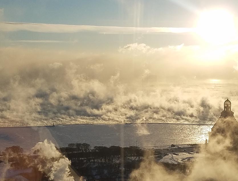
| Figure 1. Sunrise on Lake Michigan as seen from Chicago on Wednesday, January 30, 2019. Steam fog over the lake created a memorable scene. Image credit: Steve Gregory. |
At least four locations with long-term periods of record tied or set all-time record lows on Wednesday and Thursday, January 30-31:
- –33°F in Moline, Illinois, shattered the all-time record low of –28°F from Feb. 3, 1996 on Thursday, in records dating to 1874. (The all-time low from 1996 was actually broken just before midnight on Wednesday night, with temperatures dropping further early Thursday.)
- –31°F in Rockford, Illinois, on Thursday beat the previous record of –27°F from Jan. 10, 1982, in records dating to 1893.
- –30°F in Cedar Rapids, Iowa, on Thursday beat the previous all-time record of –29°F from Jan. 15, 2009, in records dating to 1893.
- –43°F northwest of Mather, Wisconsin, on Wednesday tied the all-time low from Jan. 30, 1951, in records dating to 1903.
According to weather records expert Maximiliano Herrera, who tracks all-time heat and cold records for thousands of major stations globally with a 40-year plus period of record, the three all-time cold records set (not tied) Thursday morning—in Rockford, Moline, and Cedar Rapids—are the first such records globally in 2019. We’ve never gone this deep into January without an all-time cold record being set since global record-keeping began, says Herrera. In contrast, in the Southern Hemisphere, where it is summer, January 2019 has seen two nations or territories and 33 stations set their all-time heat records.
 |
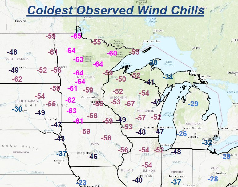
| Figure 2. Coldest wind chills from Wednesday January 30, 2019. Portions of nine states had extremely dangerous wind chills below -40°F. The bitterest conditions were in Minnesota, where the wind chill plunged to an extraordinary -66°F at Ponsford at 6:18 pm CST Tuesday night. According to the Minnesota State Climatology Office, this is close to the lowest known wind chill ever recorded in the state, a -71°F reading from January 9 – 10, 1982. The winds died down considerably by Thursday morning, and wind chills were not as extreme. Image credit: NWS. |
The coldest temperature in the U.S. from this week’s cold wave came early Thursday in Cotton, Minnesota: –56°F. That was just a few degrees short of the state's all-time record low of –60°F set in Tower on Feb. 2, 1996. Elkader, Iowa came in at –41°F on Thursday morning, just six degrees below the state record of –47°F, set at Elkader on Feb. 3, 1996 and at Washta on Jan. 12, 1912.
 |
| Figure 3. Harold ponders his morning winter romp. |
A Michigan rabbit-ometer says: it’s C-cold!
Here in Michigan, where I live (Jeff Masters), this cold blast has been unusually severe. The governor declared a state of emergency beginning on Monday night, and the state government and virtually all schools and universities were closed on Wednesday. The emergency alert system was activated Wednesday night to warn residents to turn down their thermostats in order to conserve gas, since there is a gas shortage caused by record-high demand, in combination with a fire Wednesday morning at a natural gas compressor station. I’ve got my thermostat down to 60°F, but it's more like 55°F by my window where I am typing. I'm wearing my down coat and snow pants.
It was –18°F at my backyard weather station when I started working on this post, and it was a super-cold walk to the mailbox to grab the morning paper. The inside of my nose got that funny frozen feeling that happens in extreme cold, and the snow squeaked underfoot in its characteristic high-pitched super-cold way.
However, I don’t need a personal weather station to tell me how cold it is, because I have a rabbit-ometer. Our pet rabbit, Harold, loves to go outside each morning and romp around our backyard and eat the frozen vegetation. I stand by the back door and do my morning yoga stretches and wait for him to come in, a process that usually lasts twenty minutes in the winter. Each morning this week, as the temperature has gotten colder, Harold’s outdoor adventures have been getting shorter and shorter. Tuesday morning, when it was 11°F, he lasted fifteen minutes. Wednesday morning, at –8°F, he lasted just eight minutes. This morning, when it was –18°F, I knew it was going to be a short visit when my hand froze to the door knob to let him out. Harold lasted thirty seconds outside, came in to warm up for five minutes, then bravely spent another four minutes outside before pounding frantically at the door to be let in. By applying the appropriate scaling factors to the length of time Harold spends outside, I am now confident I can surmise the temperature should my personal weather station fail!
“Flash thaw” on the way this weekend across much of Midwest, Northeast
This morning’s record-shattering cold will quickly be replaced over the next several days by unusually mild air for this time of year. Friday will still be cold—especially in New York and New England, with readings in the single digits—but nearly all U.S. stations should manage to get above zero Fahrenheit. Strong south winds will overspread the central U.S. on Saturday, pulling in much milder air. Highs will likely rise above the freezing mark in Minneapolis and Chicago by Saturday and in Detroit, Buffalo, and Boston by Sunday.
 |
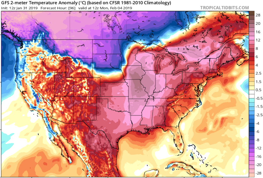
| Figure 4. Departures from average temperature (in degrees Celsius) predicted by the 12Z Thursday run of the GFS model for 7 am CST Monday morning, February 4, 2019. Readings are predicted to be 12 to 18°C (22 to 32°F) above average on Monday morning across most of the Mississippi Valley, while temperatures could be 12°C (22°F) below average over the northern High Plains of Montana and the western Dakotas. |
Mild southerly flow in the Midwest will intensify Sunday night and Monday ahead of a developing surface low in the Central Plains, stoking a phenomenal multi-day warm-up. Some spots in Iowa and Illinois that were -20°F to -30°F or colder on Thursday morning could be 40°F to 50°F by Monday morning! In Chicago, temperatures on Monday could even rise to within a few degrees of the daily record high of 59°F, set in 1890. Rapid snow and ice melt will pose a variety of concerns across the areas hardest-hit by this week’s Arctic blast.
On the back side of this low, a new surge of Arctic air will plow into the northern Plains. This blast of cold air will lack the upper-level support that was provided this week by a “daughter” spinoff of the stratospheric polar vortex, so temperatures and wind chills will be less extreme. Lows could reach –15°F to –25°F in parts of Montana, the Dakotas, and Minnesota—but such readings are not all that exceptional for these areas in early February, when daily record lows are in the –30°F to –45°F range.
Later in the week, new intrusions of cold air (short of record-smashing levels) may push into the Northern Plains, extending at times into the Southern Plains, Great Lakes, and Northeast. Much of the Southeast will trend warmer than average, and Florida will live up to its reputation as a wintertime haven, with widespread above-average highs in the ballpark of 80°F each day.
Bob Henson wrote the forecast section of this post, and Christopher C. Burt and weather.com meteorologists contributed to the observations section.
 |
| Figure 5. The 6-to-10-day outlook from the NOAA/NWS Weather Prediction Center, issued Wednesday, January 30, and valid Tuesday through Saturday, February 5-9, 2019, shows high confidence of colder-than-average conditions toward the northwest and warmer-than-average weather from the South to New England. Image credit: NOAA/NWS/WPC. |


