| Above: A house is surrounded by floodwaters from Hurricane Florence in Lumberton, N.C., Monday, Sept. 17, 2018. Image credit: AP Photo/Gerald Herbert. |
Almost three weeks since it was first classified by the National Hurricane Center, Tropical Depression Florence is spreading heavy rain and flood risk toward the Northeast U.S., and its aftermath is still plaguing the Carolinas. Florence, which is being tracked by the NOAA/NWS Weather Prediction Center (WPC), was centered on Monday morning near the Ohio/Kentucky/West Virginia intersection, heading northeast at 15 mph. Winds are no longer a major problem with Florence, as top sustained winds are just 25 mph, but rains are still a big concern, mainly well to the northeast and east of Florence’s center.
Widespread 2” – 4” rains, with pockets up to 6”, will envelop much of the interior mid-Atlantic on Monday and southern New England on Tuesday. WPC has a moderate risk of flash-flood-producing rains for Monday along a swath from northwest Virginia to south-central New York, with a slight-risk area encompassing most of the interior mid-Atlantic. The main threat north of the Carolinas is for flash flooding, although moderate river flooding was already occurring along the South River at Waynesboro and is expected by Wednesday along the Potomac at Edwards Ferry.
 |
| Figure 1. Soil moisture as of Sunday was more than 140 mm (5.5”) above average in a region across and west of the Baltimore-Washington metroplex, heightening the flood risk there. Image credit: NOAA/NWS Climate Prediction Center. |
Major routes (and many other roads) remain closed in NC:#FLORENCE #FlorenceNC pic.twitter.com/HgB05hvc4f
— Paul Woolverton (@FO_Woolverton) September 17, 2018
Major routes (and many other roads) remain closed in NC:#FLORENCE #FlorenceNC pic.twitter.com/HgB05hvc4f
— Paul Woolverton (@FO_Woolverton) September 17, 2018River flood woes will extend all week in the Carolinas
Before they can even start on recovering from Florence, folks in the hardest-hit parts of southern North Carolina and adjacent South Carolina have days of river flooding to contend with. All road transport to the region’s largest city, Wilmington, was cut off by floodwaters on Sunday, which prompted officials to explore whether supplies might need to be airlifted to the city’s 120,000 residents. Road access to Wilmington was reopened on Monday, though it may again be lost by Tuesday as river flooding begins to peak, according to the state transportation director and Governor Roy Cooper.
At least five record river crests had already been established by Monday afternoon, all of them topping records established during either Hurricane Floyd (1999) or Hurricane Matthew (2016). Most of these are predicted to remain above the previous record levels throughout this week. Records set as of early Monday afternoon include:
Northeast Cape Fear River near Chinquapin, NC: 24.21’ (old record 23.51’ during Floyd)
Northeast Cape Fear River at Burgaw, NC: 23.19’ (old record 22.48’ during Floyd)
Trent River at Trenton, NC: 29.28’ (old record 28.42’ during Floyd)
Little River at Manchester, NC: 34.3’ (old record 32.19’ during Matthew)
Black River near Tomahawk, NC: 28.71’ (old record 27.92’ during Matthew)
Other rivers expecting record or near-record flooding this week include the Cape Fear River at Fayetteville, NC; the Neuse River at Kinston, NC; the Waccamaw River near Conway, SC; and the Pee Dee River at Cheraw, SC.
At least 20 deaths have been attributed to Florence, including 14 in North Carolina and six in South Carolina. See the weather.com roundup for more on Florence’s impacts.
Manual observations after the eye of #HurricaneFlorence moved south of Wilmington , NC filled in our climate data while our automated system #ASOS was out of service on September 14-15. #ilmwx #nwsilm #ncwx #scwx pic.twitter.com/N9uNnuQ8Um
— NWS Wilmington NC (@NWSWilmingtonNC) September 17, 2018
Tallying the titanic totals from Florence’s rains
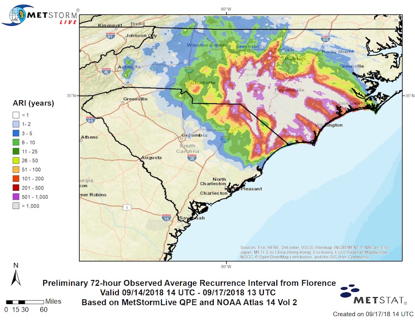
The largest reliably observed storm total from Florence as of Monday morning was 34.00” from a CoCoRaHS observer just north of Swansboro, NC. Another CoCoRaHS observer near Elizabethtown reported 35.93”, but NOAA was still in the process of confirming that total on Monday afternoon. Either way, the old record for tropical cyclone rainfall in North Carolina has been definitively smashed. Likewise, a new preliminary state record for tropical cyclone rain in South Carolina has been set with a CoCoRaHS report of 23.63” in Loris, SC.
Wilmington’s total rainfall wasn’t quite as high, but the city has already ensured its wettest year on record: 86.22" as of Sunday, with more than three months left to go. Even before Florence arrived, Wilmington had already notched its wettest January-to-August period on record.
Here’s the updated time series for Wilmington, NC accumulated precipitation. Data has a 1-2 day lag here.
— Jared Rennie (@jjrennie) September 17, 2018
Over 80” so far, has surpassed previous record. #NCwx pic.twitter.com/juzSdAmrv7
As we discussed in detail in Sunday’s post, the rainfall pattern from Florence bore many of the hallmarks of Hurricane Harvey when it loitered for days across Texas as a tropical storm. Moreover, both Florence and Harvey were positioned near concave southwest-to-northeast-oriented coastlines, which allowed the eastern swaths of the circulations to bring massive amounts of moisture northward from across very warm bodies of water (with well-above-average sea surface temperatures in both cases) onto flood-vulnerable coastal plains.
 |
| Figure 2. Preliminary maximum 72-hour Average Recurrence Interval (ARI) of the rainfall from 14Z September 14, 2018 through 13Z September 17, 2018. This was created using hourly Quantitative Precipitation Estimates (QPEs) from MetStormLive, a gauge-adjusted DualPol-radar based precipitation system operated by MetStat, and updated precipitation frequency grids, also produced by MetStat in 2014. A wide swath of North Carolina and a small section of South Carolina experienced 72-hour rains that on average occur every 1,000+ years (have a .1% chance of occurring in any given year). Note that a 1-in-1000 year rainfall event is not the same as a 1-in-1000 year flood, which depends on more than just rainfall. Image credit; MetStat, Inc. |
A much-needed breather in the tropics
As of Monday, it’s been 18 days since the National Hurricane Center issued its first advisory on Potential Tropical Cyclone 6, the system that ended up becoming Florence. The first two weeks of September saw a spate of intense tropical activity across the Atlantic as well as the Pacific. As a result, every ocean basin in the Northern Hemisphere is now running above average for accumulated cyclone energy, according to statistics maintained by Phil Klotzbach (Colorado State University). The Atlantic’s ACE is running 28% above average for this time of year, and the 10 named storms and 5 hurricanes in the Atlantic are both well ahead of average counts for this point in the season.
Favorable conditions for tropical activity early this month got a boost from sea surface temperatures that were warmer than average across large parts of the Northern Hemisphere tropics. At least part of every ocean basin on Earth saw record-warm SSTs during August, according to NOAA’s monthly climate report issued on Monday.
#Manghkut has weakened to a tropical depression. For the first time since July 31, there are no tropical storms or #hurricanes/#typhoons anywhere around the globe. pic.twitter.com/8gxcjXvH6U
— Philip Klotzbach (@philklotzbach) September 17, 2018
By Tuesday afternoon, the final advisories for both Tropical Depression Florence and Tropical Depression Joyce in the Atlantic will likely have been issued, giving no active tropical cyclones in the Northern Hemisphere (though recent model runs indicate the possibility that Florence's remnants could re-develop in the waters near Bermuda late this week).
Interestingly, if the season remained calm from here on out, we’d end up with a quieter-than-average season for the Atlantic. At this point, we can expect little more in the way of Cape Verde systems, as a large plume of Sarahan dust now covers much of the eastern Atlantic and Cape Verde season is rapidly drawing to a close. However, October is notorious for spawning hurricanes in and near the Caribbean, so it’s far too soon to close the books on the 2018 Atlantic season.
 |
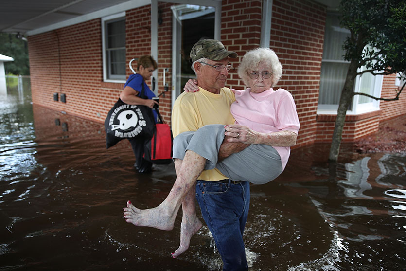
| Figure 3. Bob Richling carries Iris Darden as water from the Little River starts to seep into her home on September 17, 2018, in Spring Lake, North Carolina. Pam Darden (in backgound) helps save items from the home as flood waters from the cresting rivers inundate the area after the passing of Hurricane Florence. Image credit: Joe Raedle/Getty Images. |
Portlight disaster relief charity responding to Hurricane Florence
The Portlight.org disaster relief charity, founded and staffed by members of the wunderground community, is responding to Hurricane Florence. They need your help!! The flooding caused by Florence has left many people stranded, and experience shows that a disproportionate number of them will be people with disabilities and older adults. During Florence, Portlight’s Disaster Hotline (800) 626-4959 has already assisted many people with disabilities. They’re rallying stakeholders, working to get people to safety, providing for any immediate needs for durable medical equipment and other assistive technology, and responding to evacuation and sheltering issues and problem-solving for a variety of immediate disability accessibility issues.
Despite laws requiring equal access to emergency services and programs, massive federal funding investments and years of effort by disability organizations to compel communities to plan for the emergency and disaster related needs of 26% of the US population, it is already clear that evacuation and sheltering plans are falling short, placing individuals with disabilities and communities in jeopardy, once again. We hope you'll consider supporting Portlight's work with a donation.
Dr. Jeff Masters contributed to this post.
 |
| Figure 4. A National Guard vehicle drives past a truck washed off the roadway from floodwaters in Dillon, S.C., Monday, Sept. 17, 2018, in the aftermath of Hurricane Florence. Image credit: AP Photo/Gerald Herbert. |


