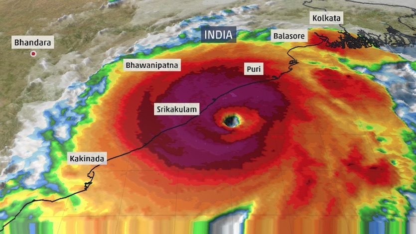
| Above: Infrared image of Tropical Cyclone Fani as of 1610Z (12:10 pm EDT) Thursday, May 2, 2019. Image credit: @SSECRealEarth/University of Wisconsin–Madison. |
After powering to top-end Category 4 strength, Tropical Cyclone Fani is taking a bead on the northeast coast of India as one of the most intense storms on record to threaten the region, prompting more than a million people to evacuate. Fani’s top sustained winds had increased to 155 mph—just 2 mph shy of Category 5—as of 12Z (8 am EDT) Thursday, according to the Joint Typhoon Warning Center (JTWC). Fani could briefly intensify to Category 5 strength before an expected landfall on Friday morning local time, or IST (Thursday night EDT) within 50 miles of the city of Puri (population 200,000). Update: As of 18Z Thursday, JTWC reported that Fani's top winds remained at 155 mph. Some weakening is expected before landfall in the Puri area around 9 to 10 AM local time Friday, but Fani will still arrive as an extremely dangerous cyclone.
Satellite images on Thursday morning EDT show a forbidding cyclone, with a crisp eye about 15 miles wide surrounded by a core of intense thunderstorms. With warm sea-surface temperatures in its path, and very favorable upper-level outflow, conditions are nearly ideal for Fani to maintain most or all of its strength in the remaining time before landfall.
 |
| Figure 1. Fani’s eye is clearly visible on this image from the radar at Visakhapatnam, India, at 1250Z (8:50 am EDT) Thursday, May 2, 2019. Image credit: IMD. |
JTWC predicts that Fani will still be a powerful Category 4 storm just before landfall. The Indian Meteorological Department (IMD) is predicting a landfall intensity of Category 3. Regardless of any potential weakening before landfall, Fani will push destructive winds and a potentially catastrophic storm surge across the coast of India’s Odisha state near and east of Puri. Because of the geography of the Bay of Bengal, which funnels and concentrates storm surge toward its north end, dangerous surge from Fani may extend to the West Bengal coast, potentially affecting areas from the coast toward Kolkata (metro area 14 million).
Correction: More than 300,000 people have already been evacuated from parts of Odisha, according to the state government, which said it plans to evacuate more than 1 million people. An estimated 10,000 villages and 52 towns are in the path of Fani, as reported by the Times of India.
See the weather.com article for more on preparations ahead of Fani. In addition, the India desk of weather.com has a continually updated page with live updates on Fani from an Indian perspective.
 |
| Figure 2. An Indian sweet vendor walks along a beach in Puri in the eastern Indian state of Odisha on May 2, 2019, as cyclone Fani approaches the Indian coastline. Image credit: Dibyangshu Sarkar/AFP/Getty Images. |
Surge, wind, and rain forecast for Fani
The official forecast from the IMD as of 12Z Thursday was for surge levels of up to 1.5 meters (4.9 feet) across low-lying areas of Ganjam, Khurda, Puri & Jagatsinghpur Districts. It appears the surge forecast is based on model output that preceded Fani’s most recent strengthening, so the actual peak surge near and just east of landfall may be considerably larger. The imminent new moon is also likely contributing to higher-than-usual high tides. High tide at Puri will be at 7:28 am IST Friday, which is quite close to the expected time of landfall. The tidal range between high and low tide was about 4.6 feet on Thursday, so arrival at high tide would add considerable impact to Fani’s storm surge.
Fani will be weakening rapidly as it moves north-northeast on Friday evening local time, moving near or just inland from the far northeast India coastline. Despite the weakening, some amount of the storm surge put into motion by Fani can be expected to progress to the northwest end of the Bay of Bengal. The megacity of Kolkata sits almost 100 miles inland from the coast, on the east side of the Hooghly River. The coastal plain from Kolkata to the bay is lined with tidal creeks and riverine channels that allow the impacts of a major surge to reach well inland. High tide in Kolkata is 12:46 pm Friday IST in Kolkata. The tidal range is huge, about 10.1 feet, so any additional surge component from Fani would most likely be felt around high tide.
 |
| Figure 3. Infrared satellite image of Fani on Thursday morning, May 2, 2019, with key cities shown. Image credit: weather.com. |
Fani’s winds are likely to cause severe damage in a concentrated area just east of the landfall location, in the storm’s more dangerous right-hand quadrant. Hurricane-force winds are expected to extend up to 30-40 miles east of where Fani’s center comes ashore. If landfall is just west of Puri, that could put the city in line for some of Fani’s worst wind impact. Villages along the coast well east of Puri will be highly vulnerable as well.
IMD is warning of a wide array of potential wind-related destruction in coastal and near-coastal parts of Odisha and West Bengal state. Some wind impacts will extend as far north and as far inland as the Kolkata area, where sustained tropical-storm force winds are possible. Among the expected wind-related outcomes in the hardest-hit areas:
—Total destruction of thatched houses
—Extenstive damage to kutcha houses (huts made of mud, wood, straw, and dry leaves), and some damage to more sturdy building
—Bending and uprooting of power and communication poles
—Major damage to roads and flooding of escape routes
—Widespread damage to standing crops and plantations
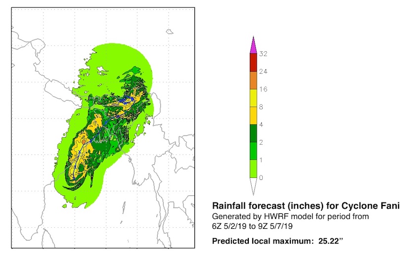
Torrential rains will accompany Fani, with the largest amounts—likely more than 10” locally—expected near the landfall location. Widespread 3” to 6” amounts will fall along Fani’s path inland, extending into northern Bangladesh. Rainfall could exacerbate surge-related flooding in some parts of far northeast India.
 |
| Figure 4. Predicted rainfall accumulation (in millimeters) near the expected landfall location of Tropical Cyclone Fani through Friday, May 3, 2019. Amounts could exceed 250 mm (9.84”) near the landfall location, which may end up slightly east of the rainfall maximum shown here. Image credit: TWC Met Team. |
 |
| Figure 5. Rainfall amounts predicted by the HWRF model for the 123-hour period from 6Z (2 am EDT) Thursday, May 2, 2019, to 9Z (5 am EDT) Tuesday, May 7. Image credit: NOAA. |
Fani is one of the strongest cyclones on record in the Bay of Bengal
According to NOAA’s historical hurricane database, Fani is the sixth strongest tropical cyclone ever recorded in the Bay of Bengal. The only five stronger storms were all Category 5s. Two of these made landfall at Category 5 strength: the 1999 Odisha cyclone and Tropical Cyclone Gay of November 1989.
Only six Bay of Bengal tropical cyclones have hit India at hurricane strength since 2000. The deadliest to hit India in the last couple of decades was the 1999 Odisha Cyclone, which struck near the city of Bhubaneswar on October 29, 1999, as a Category 5 storm with 160-mph winds. Arriving at a near-perpendicular angle, the cyclone drove a storm surge of 26 feet (8 meters) onto the coast. The storm then stalled just inland, dumping torrential rains on portions of India already saturated from the landfall of Category 4 Tropical Cyclone 04B just twelve days before. The catastrophe killed 9,658 people and left $2.5 billion in damage (1999 dollars), making it India's most expensive and fourth deadliest tropical cyclone in the past 100 years.
Cyclone season in the Bay of Bengal peaks during April-May and October-November, on either side of the monsoon season. Fani is an unusual springtime threat for eastern India, as most of the April and May cyclones in this region move east or northeast toward Bangladesh and Myanmar. In eastern India, most of the worst cyclones have struck during the fall months.
Dr. Jeff Masters contributed to this post.
Vue impressionnante du cyclone #Fani captée par le satellite japonais Himawari-8 au coucher de soleil vers 12h UTC. pic.twitter.com/BQm4gzAob9
— Keraunos (@KeraunosObs) May 2, 2019


