| Above: Hurricane Lorenzo at 11:05 am EDT October 1, 2019. At the time, Lorenzo was a Category 2 storm with 100 mph winds. Image credit: tropicaltidbits.com. |
Winds were rising and intermittent rain showers were hitting the northern Azores Islands on Tuesday afternoon as huge Category 2 Hurricane Lorenzo sped towards a Wednesday morning encounter with the islands. At 11 am EDT Tuesday, Lorenzo was racing northeast at 25 mph towards the Azores as a Category 2 hurricane with 100 mph winds. At the Flores Airport in the northwestern Azores, sustained winds of 28 mph, gusting to 33 mph, were measured during a rain shower from an outer spiral band of Lorenzo at 1:30 pm local time on Tuesday.
Satellite imagery late Tuesday morning showed that Lorenzo remained a large and well-organized hurricane, with a prominent eye surrounded by a solid eyewall of heavy thunderstorms with cold cloud tops. Wind shear was supportive of development, about 10 - 15 knots, but sea surface temperatures had fallen to a marginal 26°C (79°F).
 |
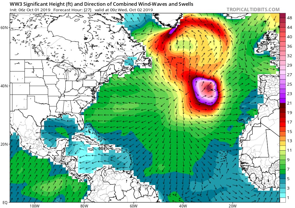
| Figure 1. Predicted significant wave height at 5 am EDT October 2, 2019, from the 6Z Tuesday, October 1, 2019 run of the WaveWatch 3 model. Wave heights in excess of 48 feet (darkest pink colors) were predicted near the center of Lorenzo as it made its closest pass to the Azores Islands. Image credit: tropicaltidbits.com |
Lorenzo was an unusually large hurricane, with hurricane-force winds that extended outwards 90 miles from the center in all directions. Along the hurricane’s eastern semicircle—the side that will affect the Azores—tropical storm-force winds spanned an area over 650 miles in diameter. This huge wind field has created large waves over a vast region of ocean; NHC estimated that 12-foot high waves spanned a region over 1200 miles in diameter (from northwest to southeast of the center) at 11 am EDT Tuesday.
Near the center of Lorenzo, the significant wave heights (mean wave height of the highest third of the waves) were predicted to be nearly 50 feet on Wednesday morning by the WaveWatch 3 model; individual extreme waves could easily approach 100 feet in height. Large swells from Lorenzo were affecting most of the North Atlantic, bringing the risk of dangerous rip currents and high surf to the U.S. East Coast, Canadian maritime provinces, the coast of Western Europe, and the north-facing coasts of the islands of the northeast Caribbean.
 |
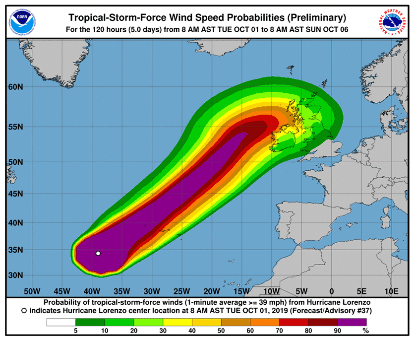
| Figure 2. Probability of sustained winds of tropical-storm strength (39 mph) along the track of Lorenzo as predicted at 11 am EDT Tuesday, October 1, 2019. The northwesternmost Azores islands of Corvo and Flores lie closest to the predicted path of Lorenzo. Image credit: NHC. |
Forecast for Lorenzo
Lorenzo will pass near the northwesternmost Azores islands, Corvo and Flores, early on Wednesday. Together, these islands hold only about 4500 of the Azores’ 250,000 residents. NHC predicts that these islands have about a 70 – 80% chance of getting peak winds of hurricane strength. However, the hurricane’s vast size means that many parts of the Azores could experience potentially damaging tropical-storm-force winds. Lorenzo is not expected to be a dangerously wet storm; NHC has cut their rainfall forecast for the western Azores to just 1 – 2”.
Lorenzo is expected to weaken only slowly before reaching the Azores, arriving as a Category 1 or 2 hurricane with winds of 85 – 100 mph. After the hurricane passes the islands, wind shear, dry air, and cold ocean waters will cause Lorenzo to transition to a hurricane-strength extratropical storm. The long-range path of ex-Lorenzo has come into better focus, and it is expected that it will bring tropical storm-force winds to portions of the UK and Ireland on Thursday evening and Friday.
#Lorenzo remains an extremely large #hurricane. Hurricane-force winds extend out 80 nautical miles away from the center in all four quadrants - the largest hurricane this far in the east in the Atlantic on record by this metric. Atlantic hurricane size database goes back to 1988 pic.twitter.com/C8ceqwwZ1w
— Philip Klotzbach (@philklotzbach) October 1, 2019
Azores hurricane history
Over the past 50 years, 20 named storms have tracked through the Azores, including four Category 1 hurricanes, according to NOAA’s Historical Hurricane Tracks website. None of these storms did significant damage, according to EM-DAT (the international disaster database) and National Hurricane Center storm summaries. There was just one fatality from these storms: Tropical Storm Bonnie, which killed one person in the Azores in 1992.
The deadliest Azores storm was a 1946 Category 1 hurricane that killed 27 people in the islands, according to EM-DAT. The strongest Azores hurricane was hurricane #8 of 1926, which made landfall on São Miguel island near Ponta Delgada while at peak Category 2 strength (105-mph winds). On January 15, 2016, Hurricane Alex—the Atlantic’s first January hurricane in more than 60 years—struck Terceira island as a high-end tropical storm. In October 2017, Ophelia passed well south the Azores as a Category 3 hurricane, producing tropical storm-force winds in the islands, according to the NHC's final report.
Elsewhere in the Atlantic
In their 8 am EDT Tuesday Tropical Weather Outlook, NHC called attention to two Atlantic disturbances with 2-day and 5-day odds of development of 10%: one in the Western Caribbean, and one a few hundred miles north of the Dominican Republic. Both of these disturbances had support for development from about 10 – 20% of the 70+ members of the 0Z Tuesday GFS and European model ensemble forecasts. In addition, about 10% of the 50+ members of the 0Z Tuesday European ensemble gave support for development early next week to a tropical wave predicted to move off the coast of Africa on Friday.
Bob Henson contributed to this post.


