| Above: Infrared image of Typhoon Hagibis at 11:40 am EDT October 11, 2019, from the Himawari satellite. At the time, Hagibis was a category 4 typhoon with 130 mph winds. Image credit: NOAA/RAMMB. |
Typhoon Hagibis continued to weaken on Friday, but was still a formidable Category 4 storm with 130 mph winds and a central pressure of 935 mb at 11 am EDT, less than 24 hours before its expected landfall near Tokyo, Japan.
Strong typhoons do not typically threaten central Japan as late as mid-October, but forecast models are in tight agreement that Hagibis will pass over the Tokyo Bay region of Japan's Honshu Island, with landfall occurring near 12Z (8 am EDT, or 9 pm local time) on Saturday. Though Hagibis is expected to make landfall, only a slight shift to the right could result in the typhoon’s eye passing just offshore, sparing Japan the worst storm surge and wind impacts.
Satellite images on Friday afternoon showed Hagibis was holding its own against dry air intruding from the west, with the typhoon featuring a small 12-mile diameter eye surrounded by a solid eyewall of intense thunderstorms with cold cloud tops. Outer bands from the large typhoon were spreading heavy rain showers across much of Japan’s main island of Honshu, as seen on Japanese radar.
 |
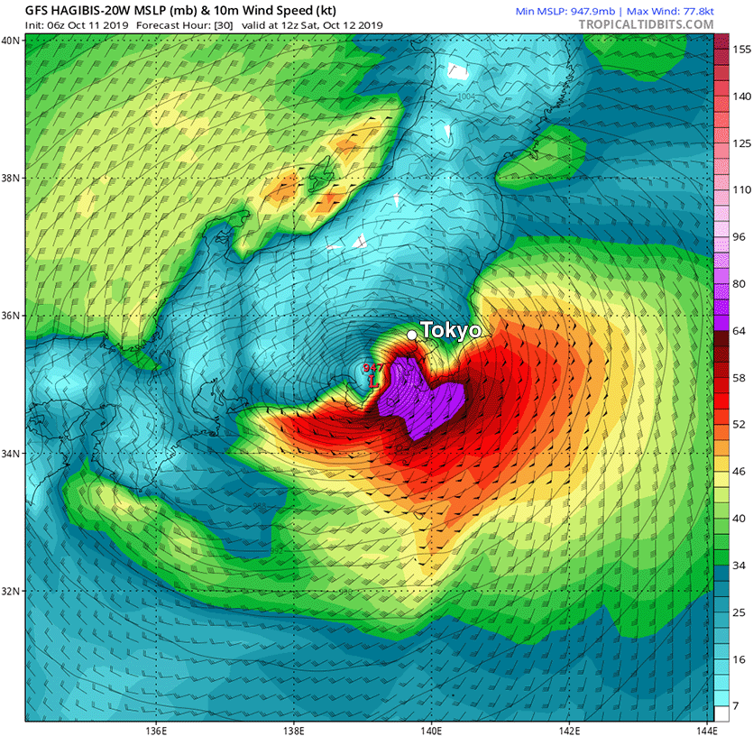
| Figure 1. Predicted surface winds (colors) and sea level pressure (black lines) at 12Z (8 am EDT) Saturday, October 12, 2019, from the 6Z Friday run of the GFS model. The model predicted that Hagibis would make landfall southwest of Tokyo as a high-end Category 1 typhoon with 90 – 95 mph winds, with the center passing over Tokyo near 13Z (9am EDT, or 10 pm local time) on Saturday. Image credit: tropicaltidbits.com. |
Hagibis was a large typhoon at 11 am EDT Friday, with hurricane-force winds that extended out 85 – 105 miles on its north side—the side that will be impacting Japan on Saturday. As cooler waters, dry air, increased wind shear, and land interaction weaken the typhoon before landfall, Hagibis’ hurricane-force wind field is predicted to shrink, and extend 20 – 45 miles to its north at the time of landfall on Saturday. The typhoon’s radius of tropical storm-force winds is predicted to be about 350 miles at landfall. This large wind field will drive a large and damaging storm surge to the coast, if the eye of Hagibis makes landfall. Extensive wind damage and flash flooding and mudslides due to heavy rain will also be major threats from Hagibis, and the typhoon is likely to bring rains in excess of 8 inches (203 mm) along a long stretch of its path.
The Joint Typhoon Warning Center predicted at 11 am EDT Friday that Hagibis would move over or near Tokyo Bay around 8 am EDT Saturday as a high-end Category 1 typhoon with 90 mph winds. These peak winds are slightly lower than those in Typhoon Faxai, which struck Tokyo Bay as a Category 2 typhoon last month, inflicting at least $7 billion in damage, according to Aon. Faxai was Japan’s sixth most damaging typhoon on record (see below). Despite the lower peak winds expected in Hagibis, it's still possible that it will inflict damage comparable to that from Faxai, given its large swath of tropical storm-force winds and the potential for significant storm surge.
Hagibis is disrupting the Rugby World Cup taking place in Japan, with two Saturday matches now cancelled, and a Sunday match between Scotland and host Japan in doubt.
Three of the top ten most damaging Japanese typhoons have occurred since 2018
According to inflation-adjusted damage estimates from Aon and EM-DAT, the international disaster database, three of the top ten most damaging Japanese typhoons since 1950 have occurred since 2018. Hagibis threatens to be another:
Mireille, 1991, $19.1 billion
Jebi, 2018, $12.6 billion
Songda, 2004, $12.5 billion
Flo, 1990, $8.0 billion
Bart, 1999, $7.8 billion
Faxai, 2019, $7.0 billion
Vera, 1959, $5.3 billion (5098 deaths)
Sarah, 1986, $5.1 billion
Vicki, 1998, $4.8 billion
Trami, 2018, $4.6 billion
This list does not include the $10.2 billion flood disaster in southern Japan in July 2018, which was caused by the presence of a stationary seasonal frontal boundary enhanced by remnant moisture from Typhoon Prapiroon.
Climate change is likely increasing Japan’s typhoon risk
Hurricane scientists agree that typhoons in the Northwest Pacific are reaching their maximum intensities at a more northerly latitude than they used to, which has increased the typhoon risk to Japan. In a 2019 review paper by 11 hurricane scientists, Tropical Cyclones and Climate Change Assessment: Part I. Detection and Attribution, nine of 11 authors concluded that the balance of evidence suggested that human-caused climate change contributed to the observed poleward migration of more intense typhoons.
In the same study, ten of 11 authors concluded that the balance of evidence suggests that there is a detectable increase in the global average intensity of hurricane-strength tropical cyclones (including typhoons) since the early 1980s, and eight of 11 authors concluded that the balance of evidence suggests that human-caused climate change contributed to this increase in intensity.


