| Above: A city truck in Dubuque, Iowa, makes its way along North Booth Street during a snowfall Thursday, Oct. 31, 2019. The city soared past its previous monthly record for October snowfall, with 9.2” falling over the last four days of the month. The previous record for any October was 4.2” in October 1997. Image credit: Dave Kettering/Telegraph Herald via AP. |
As a group, the 48 contiguous U.S. states had their coolest October in a decade, but there were stark regional departures on both the hot and cold side, according to the national monthly climate summary issued by NOAA on Wednesday. The average U.S. temperature for October of 52.34°F was 1.77°F below the 20th-century average—impressive itself in our globally warming climate—and it was the coolest since 50.50°F in October 2009. Last month ranks as the 21st-coolest October in 125 years of recordkeeping, going back to 1895.
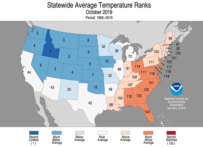
The chill was concentrated in the northwest half of the nation. All 12 of the contiguous states from Kansas northward and westward had a top-ten-coolest October. Idaho had its coolest October on record, and Wyoming came in second. A frigid-for-autumn cold blast in the last week of October played a big part in the monthly outcome, as it produced more than 4000 daily cold records across the country.
 |
| Figure 1. Statewide rankings for average temperature for October 2019, as compared to each October since records began in 1895. Darker shades of red indicate higher rankings for heat, with 1 denoting the coldest month on record and 125 the warmest. Image credit: NOAA/NCEI. |
East of the Mississippi, it was a wholly different picture. Every Atlantic state from Florida to New Jersey—plus West Virginia—had a top-ten-warmest October. Florida had its second warmest October, and Georgia and South Carolina placed third. The warmth was especially dramatic early in the month, when many Southern cities had their latest 100°F weather observed in any year (see our roundup).
For more on the bumper crop of various single-city records set during October, see the roundups from WU weather historian Christopher Burt and weather.com’s Jon Erdman
The October chill helped bring the year-to-date national average temperature down to 41st warmest out of 125 years of record. This is in stark contrast to the world as a whole, which is having one of its hottest years on record. The global map for October is almost comical in its portrait of an unusually cool North America and unusual warmth almost everywhere else.
Last month's temperatures were 0.69°C above average, making #October 2019 the hottest on record. As can be seen in the picture, large parts of the #Arctic, most of #Europe, the eastern #USA and #Canada were most affected.
— Copernicus EU (@CopernicusEU) November 5, 2019
Read the report here: https://t.co/aMmEm0c65b pic.twitter.com/zetwZo6CaE
The oddly isolated coolness in North America is surely the result of multiple factors. One obvious one is the extreme oceanic warmth or “marine heatwave” in recent months from the northeast Pacific through the Bering Sea to the Chukchi Sea, which is experiencing a record-late freeze-over. The oceanic warmth over that region is increasingly linked to strong atmospheric ridging overhead and deep troughing downstream; the latter is pushing cold air from higher latitudes across the heart of North America.
The persistent northwest-to-southeast temperature split across the Lower 48 shows up clearly in the readings for 2019 to date. The year so far is the hottest on record from Florida to Virginia and West Virginia. Meanwhile, it’s the 7th coldest year to date in South Dakota and the 12th coldest in North Dakota. We’ll have more on the global climate for October in a roundup later this month, after NOAA and NASA release their monthly summaries.
 |
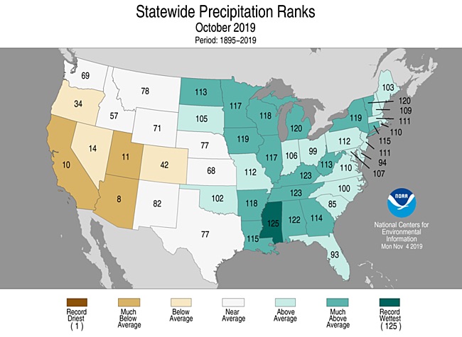
| Figure 2. Statewide rankings for precipitation for October 2019, as compared to each October since records began in 1895. Darker shades of green indicate higher rankings for moisture, with 1 denoting the driest month on record and 125 the wettest. Image credit: NOAA/NCEI. |
A sopping-wet October
After a slightly dry September, the contiguous U.S. went back to the dampness that’s characterized much of the nation for more than a year now. It was the nation’s fourth wettest October in 125 years of recordkeeping. A total of 13 states had a top-ten-wettest October, including almost every state bordering the Mississippi River. It was the wettest October on record for the state of Mississippi, in part due to rains associated with Tropical Storm Olga. Dryness prevailed in most areas west of the Rockies, with California and Arizona notching a top-ten-driest October.
 |
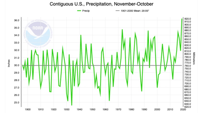
| Figure 3. Precipitation totals for 12-month spans from November to the following October, going back to 1895. The span from November 2018 to October 2019 trounced the previous record for all Nov.-to-Oct. periods. Image credit: NOAA/NCEI. |
Another soggy 12 months behind us
Once again, the last 12 months have set an impressive precipitation record, goosed by the wetness of last month. The national average of 36.21” for Nov. 2018 – Oct. 2019 marks the wettest November-to-October period on record, trouncing the old record of 34.77” (1972-73) by more than an inch.
Year-to-date precipitation (January-October) has also set a new record, at 30.25”. This year so far is the wettest on record in Illinois, Michigan, Minnesota, South Dakota and Wisconsin, and a top-three wettest in Indiana, Nebraska, North Dakota, and Tennessee.
The period from October 2018 to September 2019 ranks sixth among the 1487 overlapping 12-month spans going back to January 1895:
37.86" July 2018–June 2019
37.73” August 2018–July 2019
37.68” June 2018–May 2019
37.55” September 2018–August 2019
36.45” October 2018–September 2019
36.21” November 2018–October 2019
36.20” May 2018–Apr. 2019
35.95” May 2015–Apr. 2016
35.78” Apr. 2015–Mar. 2016
35.73” Mar. 2018–Feb. 2019
Amazingly, all ten of these 12-month spans have occurred in the last six years—and the seven wettest have all occurred since 2018. Even given the fact that a very wet span of a few months will be factored into such listings more than once, this is still remarkable testimony to the power of our warming climate to make extreme rain events even more extreme.
Long-range outlooks suggest the U.S. Midwest has a good chance of staying wetter than average through this winter, which could mean big trouble when snowmelt season arrives next spring. "Imagine putting a soaking wet sponge in the freezer, taking it out, and then trying to pour water on it. The water is going to immediately run off," South Dakota state climatologist Laura Edwards said in a National Weather Service flood outlook, illustrating the status of the state's soil conditions approaching winter and how the soil is expected to respond in spring.


