
| Above: Visible satellite image of Dorian at 11:30 am EDT August 30, 2019, when a large and prominent eye had just begun to appear. Image credit: NOAA/RAMMB. |
Confidence is increasing that Dorian will be a dangerous major hurricane that will bring devastating winds, storm surge, and rains to the northwest Bahamas on Sunday and to Florida on Monday and Tuesday. The hurricane is expected to slow at landfall in Florida to a forward speed near 5 mph, resulting in punishing long-duration hurricane conditions. Update (9 pm EDT): Dorian is now a Category 4 hurricane with sustained winds near 130 mph, according to a special update issued by the National Hurricane Center. Further strengthening into Saturday is quite possible.
At 11 am EDT Friday, Dorian was an upper-end Category 2 hurricane with 110 mph winds and a central pressure of 972 mb, headed northwest at 10 mph. Hurricane hunter data and satellite images have shown relatively little change to the storm this morning, with the winds ranging from 105 – 110 mph and the central pressure ranging from 972 – 979 mb.
Dorian is now a well-organized, medium-sized hurricane that has increased in size over the past day. Low-level spiral banding and upper-level outflow have both improved, though dry air and an area of moderate wind shear impinging on the southwest side of Dorian have been helping limit intensification.
A hurricane hunter eye report from 12:14 pm EDT Friday found that Dorian’s central pressure had dropped to 966 mb, and the hurricane had completed yesterday’s eyewall replacement cycle (ERC). Dorian now has a single eyewall with a diameter of 30 miles, instead of two concentric eyewalls. The new eyewall structure is more conducive for strengthening than the old one, since the two eyewalls were competing for resources. The Hurricane Hunters noted that the eyewall did not form a full ring around the calm eye—there was a gap in the southwest side. Unless this gap closes off, Dorian is likely to only undergo slow intensification, not rapid intensification. You can see the gap in the eyewall on the radar display in the tweet below, taken from the NOAA hurricane hunter mission this morning.
Recent radar images of Dorian's eye taken from the NOAA P-3 aircraft. pic.twitter.com/vPSGkS1Sqf
— National Hurricane Center (@NHC_Atlantic) August 30, 2019
Intensity forecast for Dorian
Dorian is likely to strengthen in the coming days, and perhaps undergo a round of rapid intensification. For the remainder of today, intensification will likely be slow, due to moderate wind shear impinging on the hurricane’s southwest flank from an upper-level low. This low is expected to weaken and move away by Saturday, and we may see more significant strengthening into a Category 4 hurricane then.
Over the next three days, wind shear is expected to mostly be light, less than 10 knots, and mid-level relative humidity will increase from around 55% to around 65%. Dorian will be passing over very warm water, with sea surface temperatures of around 29.5 - 30.5°C (85 - 86°F)--about 1.0°C (1.8°F) warmer than average.
Oceanic heat content (OHC) will be above 50 kilojoules per square centimeter along much of Dorian’s path for the next three days. Values above 75 kJ/sq cm are most closely associated with higher odds of rapid intensification, but we often see rapid intensification when OHC is between 50 – 75 kJ/sq cm.
The Rapid Intensification Index in the 12Z Friday run of the SHIPS and DTOPS models gave a 28% and 19% chance, respectively, of Dorian’s sustained winds increasing by 30 mph by Saturday morning, which would make it a Category 4 hurricane with 135 mph winds.
Expect Dorian to experience at least one more eyewall replacement cycle (ERC) before any U.S. landfall. These cycles can produce a dip in strength lasting a day or so, as the inner eyewall collapses and is replaced by the outer eyewall, but they also tend to enlarge a hurricane. Between this possible effect and the tendency of hurricanes to expand over time and with latitude, we can expect Dorian to be larger at landfall than it is now, with a larger wind field.
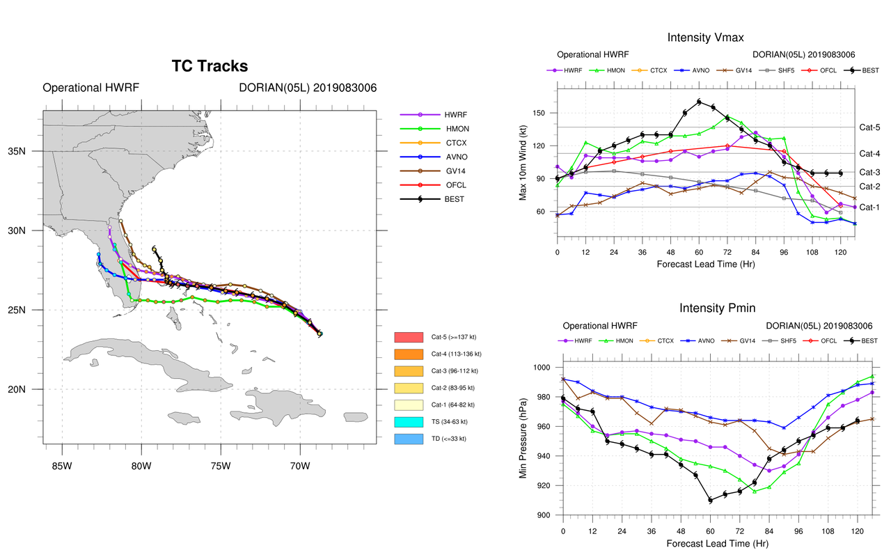
Among our top intensity models, their 6Z Friday runs predicted Dorian would peak off the coast of Florida on Monday somewhere between Category 3 (GFS model) and Category 5 (HMON model).
Bottom line: expect Dorian to peak at Category 4 strength as it approaches the Southeast U.S. coast, and affect Florida as a Category 3 or 4 hurricane.
 |
| Figure 1. Predicted wind speeds (colors) and pressure (black lines) for Dorian at 11 pm EDT Monday, September 2, 2019, from the 6Z Friday, August 30, 2019 run of the HWRF model. This model, one of our top three performing intensity models at long ranges last year, predicted that Dorian would make landfall as a Category 4 hurricane with 135 mph winds just north of West Palm Beach, Florida. Image credit: tropicaltidbits.com. |
Track forecast for Dorian
Over the next day, Dorian should make a turn toward the west-northwest, as it feels the steering effects of a westward extension of the Bermuda high to it north and a weak upper low to its southwest. Dorian will head west or west-northwest toward the Southeast U.S. coast over the weekend, with a landfall in central Florida on Monday night or Tuesday morning the most likely scenario.
The models have come into better agreement with their 0Z and 12Z Friday runs, which is likely partially due to the ingestion of dropsonde data from the NOAA jet that flew on Thursday afternoon. Track forecasts can improve by up to 15% when data from the NOAA jet is available. The model consensus is that Dorian will pass through the northwest Bahamas on Sunday, gradually slow to a forward speed of just 5 mph by Monday night, then come very close to or make landfall in central Florida on Monday night or Tuesday morning.
Near the time Dorian approaches landfall in central Florida, the hurricane will be entering a region of weak steering currents and is expected to turn fairly sharply north, thanks to the fact the hurricane will be moving clockwise around the western edge of the Bermuda High. This northward turn could come before Dorian reaches the coast of Florida. Update: based on the 12Z Friday runs of the models, I estimate there is a 40% chance that Dorian will miss making landfall in central Florida, and instead make landfall farther north on the Southeast U.S. coast. Dorian could completely miss making a U.S. landfall and recurve out to sea; I give a 20% chance of this happening. In these scenarios, Dorian would still likely cause billions in storm surge and fresh water flooding damage, though.
It also remains possible that Dorian will make landfall farther to the south, near Miami, cross the entire peninsula, and go on to pose a threat to the northern Gulf Coast. This was an outcome favored by the 6Z Friday run of the HMON model, though the more recent 12Z run favored a central Florida landfall near Cape Canaveral. Remember, if you are in the NHC cone of uncertainty, you are in danger of a direct strike! Don’t focus on the skinny line going through the center of the cone. If you live in Florida, get your preparations done by Sunday. By Monday morning, the winds will begin rising and heavy rain will begin falling, making preparations and evacuation difficult.
The track is going to still shift run-to-run as the model resolves the tropical cyclone, but there's potential here for extremely high rainfall totals (over 30-inches in some eastern FL locations in the path of #Dorian) if this "stalling" scenario takes place. pic.twitter.com/mzQSkVwuAe
— Michael Ventrice (@MJVentrice) August 30, 2019
Slowing to a crawl at landfall
As we’ve seen several times in recent years—with Hurricane Florence in North Carolina in 2018 and Hurricane Harvey in Texas in 2017—Dorian is expected to encounter an area of weak steering currents near the projected time of landfall and dramatically slow its forward speed. As we discussed in our June 2018 post, Observed Slowdown in Tropical Cyclone Motion May Portend More Harvey-Like Rainstorms, the forward speed of tropical cyclones (which includes all hurricanes, tropical storms, and tropical depressions) has decreased globally by about 10% since 1949, and we’ve seen a 20% slow-down in storm translation speed over land for Atlantic storms since then. There is at least one modeling study that has found that human-caused climate change can be expected to cause such effects.
Dorian’s forward speed of 10 mph observed on Friday morning is expected to decrease to 5 mph by Monday evening, when the hurricane will be near the Florida coast.
This slowdown has a number of important implications:
1) The coast will be subject to much heavier accumulations of rain. Dorian will be able to dump nearly twice as much precipitation than if it were making landfall at 10 mph. There is the potential that Dorian could dump 30” of rain in isolated regions of Florida in a bad-luck stalling scenario (see tweet by Michael Ventrice above). The 12Z Friday runs of the GFS and UKMET model predicted Dorian would follow a slow path arcing along the coast from central Florida to North Carolina, which would likely result in a large swath of 6 - 10" of rain along this entire path.
2) Coastal flooding will occur over multiple high tide cycles. With Dorian’s heavy rains falling continuously for days, rainfall runoff flowing into the ocean will back up inland, creating a destructive compound flooding event from the combination of storm surge and rainfall runoff. Storm surge expert Dr. Hal Needham has a Friday morning blog post up on the threat.
3) Structures will be battered by high winds for an extended period of time, increasing the chances of structural failure.
4) The right-front eyewall (the northern side) will be more destructive that the southern eyewall, but this difference will be less than usual. In a fast-moving landfalling storm coming ashore at 15 mph, the peak winds on the right-front side of the hurricane can be expected to be about 30 mph greater than those on the left-front side. If Dorian is making landfall at just 5 mph, this difference will be more like 10 mph. Thus, the “weak” southern side of Dorian’s eyewall will not be all that weak; the hurricane’s destructive winds will be spread out over a larger area, and not focused in a relatively narrow region in the right-front quadrant.
5) When a hurricane slows to a forward speed of just 5 mph, it typically begins to weaken, since slow-moving storms are unable to “outrun” the large amount of cooler water from the depths that their winds stir to the surface. Thus, I expect that Dorian will reach peak intensity over The Bahamas and then weaken as it approaches Florida. This weakening will be less than one usually sees for a slow-moving storm, since the warm waters of the Gulf Stream lie directly adjacent to the Florida coast. This powerful current will be able to supply a continuous stream of warm water from the south to offset the cooling that upwelling from Dorian’s winds cause. Weakening can also be expected near landfall since the hurricane will have a large part of its circulation over land, limiting the amount of moisture that feeds into it.
Bob Henson contributed to this post.


