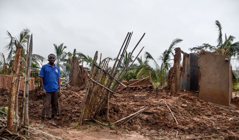
| Above: Assan Madal stands next to his destroyed house in the village of Nacate, south Macomia, Cabo Delgado province, Mozambique, on April 27, 2019, after Tropical Cyclone Kenneth hit the area. Image credit: Emidio Josine/AFP/Getty Images. |
At least 42 people have died in far north Mozambique and the Comoro Islands as a result of Tropical Cyclone Kenneth, the strongest storm on record to make landfall in both areas. Kenneth clipped the northern end of Grande Comore island before storming to Category 4 strength and making landfall on Thursday in northern Mozambique’s Cabo Delgado province. Kenneth’s powerful southern eyewall struck the small villages and resorts of Quirimbas National Park and its Quisinga Islands.
Officials said on Monday that the death toll in Mozambique had jumped to 38, as reported by weather.com. Although Kenneth weakened quickly as it moved inland, its remnants have continued to produce torrential rain across Cabo Delgado. Runoff and local rains have led to widespread flooding in Pemba, a city of 200,000 well south of where Kenneth made landfall.
More than 31,000 houses in Mozambique were totally destroyed and another 3800 partially destroyed, according to the National Institute for Disaster Management (INGC), ReliefWeb reported.
We just visited Mahate neighbourhood in Pemba, where landslides are feared. The population is still in the zone, with some houses too close to this large crack crossing the community. @ICalamidades is mobilizing a team to evacuate the area.
— OCHA Southern & Eastern Africa (@UNOCHA_ROSEA) April 28, 2019
Photos: OCHA/@savianoabreu pic.twitter.com/c3ISVDl6H7
In the Comoros, at least 4 deaths and 182 injuries have been reported, according to government figures cited by ReliefWeb. Some 3800 homes in the Comoros were completely destroyed and about 7000 partially destroyed. The island nation has about 1 million residents. Almost two-thirds of the nation’s food crops have been wiped out, and most residents are without power, reported the Internal Displacement Monitoring Center.
NOAA’s historical database shows that Kenneth is the first hurricane-strength cyclone on record to strike either Cabo Delgado or the Comoros. Routine satellite monitoring of the region extends back to the late 1990s, though some cyclone records go back 50 years. According to EM-DAT, the deadliest and most destructive tropical cyclone to affect the Comoros was Elinah, which passed through the islands as a tropical storm with 45 – 50 mph winds on January 11, 1983, killing 33 people and doing $23 million in damage. All 33 deaths occurred when a huge wave swept 40 people on the island of Anjouan into the water.
Devastating images from #Comoros following #CyloneKenneth.
— IFRC Africa (@IFRCAfrica) April 25, 2019
Homes and roads are damaged and destroyed, telephone poles and trees are down. Red Crescent volunteers are supporting the urgent needs of communities, providing first aid and assessing needs on the ground. pic.twitter.com/Fl0t5C3vh1
Kenneth struck just less than two months after catastrophic Cyclone Idai ripped through central Mozambique, bringing devastating floods to the city of Beira and taking at least 1000 lives. The damage estimate of $1 billion to Mozambique’s infrastructure from Kenneth alone is around 5% of that nation’s gross domestic product. A comparable hit to the United States would be a storm causing more than $1 trillion in infrastructure damage.
The only other time on record Mozambique has experienced two cyclones in the same year was in 2000, when Cyclone Eline (Leon-Eline) struck south of Beira as a Category 4 on February 22, followed by Cyclone Hudah, which struck further north, near Pebane, as a Category 1 storm on April 8.
 |
| Figure 1. Satellite-based estimates of rainfall for the week ending Saturday, April 27, 2019, show a large area of more than 200 mm (7.87”) of rainfall over eastern Cabo Delgado province of Mozambique (dark purple area at top). Estimates approached 500 mm (19.69”) along the coastline where Kenneth made landfall. Additional rains have fallen over eastern Cabo Delgado since Saturday. Very heavy rains also fell in parts of northeast Madagascar that are more accustomed to large rainfall totals. Image credit: NOAA/NWS Climate Prediction Center. |
Fani a substantial threat for eastern India late this week
A slow developer over the weekend, Tropical Cyclone Fani has the potential to cause big trouble in eastern India and perhaps Bangladesh toward the end of this week. As of 12Z Monday, Fani was a tropical storm with 1-minute sustained winds of 65 mph, according to the Joint Typhoon Warning Center (JTWC). Fani was located about 480 miles southeast of Chennai, India, moving northwest at about 9 mph. An eye was already becoming evident in microwave imagery on Monday morning.
Conditions will be nearly ideal for Fani to strengthen over the next couple of days, and a period of rapid intensification is very possible. Fani will be moving over very warm sea surface temperatures of around 30-31°C (86-88°F), about 1°C above average for of year. Oceanic heat content will be quite high along Fani’s path, enhancing its odds of rapid strengthening (see Figure 2). Outflow jets to the north and south of Fani will further support the storm, and moderate wind shear of 10 – 15 knots is unlikely to impede Fani’s growth. The HWRF model, one of our top performers on cyclone intensity, has been predicting Fani will reach at least Category 3 strength prior to landfall, and we cannot rule out even greater intensification.
 along the path of Tropical Cyclone Fani projected by the Joint Typhoon Warning Center as of 6Z Monday, April 29, 2019") |
| Figure 2. Oceanic heat content (OHC) along the path of Tropical Cyclone Fani projected by the Joint Typhoon Warning Center as of 6Z Monday, April 29, 2019. OHC values in excess of 100 kilojoules per square centimeter (darker orange colors) are commonly associated with rapid intensification of tropical cyclones. Image credit: NOAA/RAMMB. |
Fani appears destined to angle toward the north and northeast later this week, as a weak upper-level trough approaches from the northwest. In their 0Z and 6Z Monday runs, our top long-range track models—GFS and European models—came into closer agreement on a track that would bring Fani very near the the coast of Odisha state on India’s east coast around Friday night, then hug the coast toward the upper end of the Bay of Bengal. In its 12Z Monday advisory, the JTWC adheres closely to this model consensus, calling for a Category 3 strength at landfall.
The forecast trajectory for Fani could push a significant storm surge well northeast of the cyclone’s landfall location, toward the Kolkata area at the head of the Bay of Bengal. Only a slight eastward jog would bring Fani into the Kolkata area and/or western Bangladesh at full force. Some of the most catastrophic cyclones in world history have struck this region, where a northward-moving storm surge can be concentrated by the bay into a compact delta where tens of millions of people live. Kolkata alone has a metropolitan population of around 14 million. A cyclone on October 5, 1864, took some 60,000 lives in Kolkata (then Calcutta).
Tropical cyclones are most common in eastern India during October and November, but there is a secondary peak in April and May.
 Monday, April 29, 2019") |
| Figure 3. Enhanced infrared satellite image of Tropical Cyclone Fani at 1545Z (11:45 am EDT) Monday, April 29, 2019. Sri Lanka and southeast India are outlined at left. Image credit: RAMMB/CIRA/Colorado State University. |
India's tropical cyclone history
A total of six Bay of Bengal tropical cyclones have hit India at hurricane strength since 2000. Two of the most intense in recent years, Cyclone Phailin (October 2013) and Cyclone Hudhud (October 2014), both approached the east coast of India from the southeast, much like Fani. Phailin was a Category 5 cyclone, weakening to Category 4 strength before making landfall in Golpapur in Odisha state; it caused 45 deaths and inflicted $655 million in damage (2013 dollars). Hudhud struck a bit further southwest, near Visakhapatnam in Andhra Pradesh state, at its maximum Category 4 intensity, leading to 124 deaths and $3.4 billion in damage (2014 dollars).
The deadliest tropical cyclone to hit India in the last couple of decades was the 1999 Odisha Cyclone, which hit Northeast India in the Indian state of Odisha (which was called Orissa until 2011) near the city of Bhubaneswar as a Category 4 storm with 155 mph winds on October 29, 1999. The mighty storm, which had been at Category 5 strength with 160 mph winds and a 912 mb central pressure shortly before landfall, drove a storm surge of 26 feet (8 meters) onto the coast. The storm stalled just inland, dumping torrential rains on portions of India already saturated from the landfall of Category 4 Tropical Cyclone 04B just twelve days before. The catastrophe killed 9,658 people and left $2.5 billion in damage (1999 dollars), India's most expensive and fourth deadliest tropical cyclone in the past 100 years.
Six other Indian tropical cyclones occurring before 1900 were even deadlier; see wunderground's list of the 35 Deadliest Tropical Cyclones in World History. During the past two centuries, 42 percent of Earth's tropical cyclone-associated deaths have occurred in Bangladesh, and 27 percent have occurred in India. (Note that Bangladesh was governed by Britain as part of India from 1858 until 1947, when it became East Pakistan; it gained independence in 1971 as Bangladesh.)
As Christopher Burt observed in a 2013 post, “Most of the deadliest tropical storms on earth have occurred in the Bay of Bengal when tremendous storm surges have swamped the low-lying coastal regions of Bangladesh, India, and Burma [now Myanmar]. The worst of all was the Great Boha Cyclone of November 12-13, 1970, when a 40-foot storm surge overwhelmed the delta islands of the Brahmaputra and Ganges Rivers in Bangladesh. An estimated 300,000-500,000 perished. This storm is also considered to have produced the greatest storm surge of any Indian Ocean cyclone, although similar surges may have occurred during the 1733 and 1876 cyclones.”
Dr. Jeff Masters contributed to this post.


