| Above: A scientist walks toward an ice ramp formed from strong wind blowing through a moraine ridge gap at the edge of the Greenland Ice Sheet near Thule Air Base in early June 2018. Sampling snow from varied polar environments helps us better understand current and past climate change. Image credit: Pete Akers. |
Editor's note: Paleoclimate researcher Pete Akers (Institut des Géosciences de l’Enivironnement or IGE in Grenoble, France) is a participant in the 2019-20 East Antarctic International Ice Sheet Traverse (Project EAIIST). Pete is writing about the project in a special series for Category 6. See Pete's author page for other posts in the series.
As the Earth steadily warms in the coming decades and centuries, what is the fate of Antarctica? Headlines about collapsing ice shelves and thinning glaciers that come out of Antarctica on a regular basis seem to paint a clear and simple picture of a doomed continent that will inevitably melt away. The concern is easy to understand: if all the ice atop Antarctica were to disappear, it would raise sea levels over 200 ft (60 m). In reality, while our understanding of Antarctica has dramatically improved in recent decades through the rise of satellite observations and dozens of national programs dedicated to Antarctic research, many very basic parts of Antarctica’s environmental system remain mysteries.
As a postdoctoral researcher with the Institut des Géosciences de l’Enivironnement (IGE) in Grenoble, France, I am a member of a team focused on solving one of the biggest outstanding mysteries today: how much sea level rise can we expect from East Antarctica in the coming years? And to complete our mission, we’ve put together an international team that will travel hundreds of miles across a remote and previously unstudied region of Antarctica this December and January. Along the way, dozens of scientific studies will be taking place, including weather and pollution observations, earthquake detection, and coring of the ice sheet itself. This is the East Antarctic International Ice Sheet Traverse (Project EAIIST), and I hope you follow along as I cover our project and the wider world of Antarctic climate research in a series of blog posts for Category 6.
 |
| Figure 1. The official logo of Project EAIIST. |
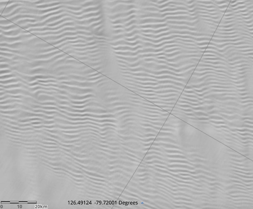
Our primary destination for the EAIIST mission is a rarely studied region of remote interior Antarctica called the Megadunes site after its dominant feature: parallel wave-like snow ridges on the ice sheet surface 1-2 miles apart and extending out like stripes over 50 miles, but less than 15 feet tall. The area is exceptionally dry, even for Antarctica, with many landforms and snow structures found here and nowhere else on Earth. We believe this environment and landscape at Megadunes is similar to what much of the rest of East Antarctica would have been like during the coldest points of Earth’s recent past. This is very important because a huge amount of our knowledge of past global climate change comes from deep ice cores taken from other sites in Antarctica, but we aren’t entirely sure how the extreme environmental conditions at these core sites during the frigid maximal cold periods might have affected the chemical and physical properties of the snow and ice. We hope that by studying the environment at Megadunes, we can better interpret and understand how Antarctica’s glaciers have grown and shrunk in response to major periods of warming and cooling in the past. This in turn, can help us better predict future effects of modern climate change in Antarctica, such as how much it will contribute to sea level rise.
 |
| Figure 2. Elevation data revealing the megadune structures at our destination site. These structures are actually very subtle when observing in person from the surface, as the elevation difference in the dunes is less than 15 feet spread out over 1-2 miles. Image created using the Reference Elevation Model of Antarctica (REMA). |
The EAIIST mission
After traveling from France to Hobart, Tasmania, our mission will begin on November 10 with a flight to Dumont d’Urville Station, a French research base on the coast of Adélie Land perhaps best known for being the filming site for March of the Penguins, which won the 2006 Oscar for Best Documentary Feature. Dumont d’Urville was built in 1956 and has been staffed year-round ever since. At 66.7°S in latitude, the station lies just outside the Antarctic Circle and temperatures are quite mild for Antarctica. In summer, the mean daily temperature is slightly below freezing, but strong winds flowing off the ice sheet (katabatic winds) make this one of the windiest coastal locations on Earth.
#GoodNewsTues Last week saw the hatching of the first Emperor penguin chicks near Dumont D’Urville Station in #Antarctica!
— Antarctic Survey (@BAS_News) July 16, 2019
Emperor penguins breed the furthest south of any penguin species, forming large colonies on the sea ice.
Photo credit: Virgil Decourteille @_IPEV pic.twitter.com/wzIE3t6zfg
Most of our gear left France back in June and will meet us on arrival in Antarctica after a long transoceanic voyage. After a little over a week of logistical prep work at Dumont d’Urville, I and three other team members will join a supply traverse that is ferrying fuel and other critical materials to Concordia Station high on the East Antarctic Ice Sheet. A traverse is basically a convoy of sleds pulled over the snow and ice by special ice tractors, and they are the most efficient way to transport goods across an ice sheet.
Big science meets heavy haulage. The first of five heavy tractors chosen to power Australia's new Antarctic deep-field traverse capability has arrived in Hobart, where it will be modified to support the search for a million year ice core. pic.twitter.com/Ke07p64RYU
— antarctica.gov.au (@AusAntarctic) March 28, 2019
Elevation increases rapidly as you go inland from the coast and soon you are on the East Antarctic Plateau, the nearly flat surface of the ice sheet over 6000 ft (1800 m) in elevation. Conditions here are brutally cold and dry: the coldest temperature ever recorded on Earth was at Vostok Station on the plateau at -128.6°F (-89.2°C) on July 21, 1983, and total snowfall is generally less than 10 in (25 cm) per year. It will be nearly the summer solstice when we arrive, with 24 hours of sunlight per day, yet the temperature will likely stay below -10°F (-20°C) our entire stay and may approach -40°F/C at times. The traverse route from the coast to Concordia Station is well established, but it takes over a week to travel its 600 miles (960 km) at the blistering tractor speed of 6 mph.
For anyone asking.... It’s best to not have noodles outside in Concordia Station, #Antarctica... this was on the 1st October with temperatures below -50c. Report; @CyprienVerseux #severeweather #freeze #snowfall pic.twitter.com/e9fRKt09oZ
— WEATHER/ METEO WORLD (@StormchaserUKEU) October 4, 2018
 |
| Figure 3. Antarctica with the stations and routes I’ll be traveling as part of Project EAIIST. Image credit: Pete Akers, based on imagery from U.S. Department of State/U.S. Geological Survey/Landsat/Copernicus/Google Maps. |
Concordia Station is located at the top of one of the ‘peaks’ of the ice sheet called Dome C. You wouldn’t know it from standing there as the surface’s slope is nearly flat, but the station lies at over 10,000 ft (3000 m) elevation and it is 13,000 feet (3200 m) of ice straight down until you hit bedrock.
Concordia station is moving to winter configuration, leaving behind a handful of women and men who will brave the Antarctic winter. Zucchelli station will also close soon. Temperatures are dropping fast. Thanks to Angelo Domesi for his beautiful photos. @ItaliAntartide pic.twitter.com/Vp9lYHWzON
— Italy in New Zealand (@ItalyinNZ) February 3, 2018
Concordia was built as a joint French-Italian base in 2005 as only the third year-round base on the ice sheet (after the US Amundsen-Scott Station at the South Pole and the Russian Vostok Station), with a winter population of 13 hardy souls and a summer population of around 50. The average annual temperature at Concordia is -66°F (-55°C), and the site has never recorded a temperature above freezing. Being at a high point on the plateau, Concordia is not affected by the gravity-fed katabatic winds that dominate Dumont d’Urville, and many days can be quite calm.
Concordia is well known as the drilling site for the EPICA Dome C ice core: the oldest continuous ice record that covers the past 800,000 years. Anytime you read a climate article that mentions “800,000 years ago” as a reference point (such as, “the highest CO2 levels in 800,000 years”), they are using the data pulled from this two-mile-long ice core. Concordia serves as our home base of operations, and on December 5, our team of six scientists and four logistical staff set out on the official EAIIST traverse.
To get to our Megadunes destination, we will travel nearly 400 miles (650 km) south from Concordia, forging our own path across the ice sheet. Our traverse will have six tractors pulling living quarters, a cold lab, a warm lab, a sample storage container, and fuel for the entire trip. This gives us an effective travel range of 800 mi (1300 km) for a 50-day mission. Twenty of these days will be spent entirely on driving with 30 days dedicated to science. The bulk of the science will be performed at the Megadunes site and around this general area. With the typically strong high pressure and dry air over the plateau, we hope for a lot of clear skies and calm conditions. Temperatures on the traverse and at the Megadunes site will be similar to those at Concordia. In a later post, I’ll go into further detail on the clothing and safety precautions we must take to do our travel and work in such frigid conditions.
The mission is split into two legs: one trek out to the Megadunes and one trek to return to Concordia. Halfway during the science period at Megadunes, a ski plane will arrive for a partial science team exchange. I will take part in the first leg of the traverse to Megadunes, but fly back to Concordia on Christmas Day as another scientist takes my spot for his research on the return traverse. The first leg includes me (an atmospheric geochemist and paleoclimatologist), two other snow and atmospheric chemists, a snow physicist, and two geophysicists. As support, we also have a traverse chief, a vehicle mechanic, and a doctor who also serves as our cook.
Here’s another Basler in #Antarctica, the first aircraft of the summer to land at the high altitude runway at Concordia Station alt 3233m, on the polar plateau, pic @CyprienVerseux IPEV / PNRA @ItaliAntartide pic.twitter.com/M346rmgSQd
— The Antarctic Report (@AntarcticReport) November 9, 2018
At stops along our traverse, we will be setting up automated weather and seismic stations as well as taking snow samples to test for physical properties and later chemical analyses. Although we each have our own individual research tasks (like my snow and air sampling), everyone helps each other out in the field to get everything done successfully, safely, and quickly. Science isn’t just restricted to times we are stopped: as we travel, a machine will continuously be sampling the water vapor geochemistry, and a snow-penetrating radar pulled behind one tractor will reveal the ice structure far below the surface. Finally, we will also drill a series of ice cores, including at least one 600-ft (200-m) core at Megadunes to make a climate record that may extend back over 4000 years. These cores will be cut into pieces and shipped (carefully and frozen!) to research partners at institutions across Italy, France, and Australia
 |
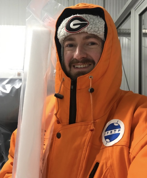
| Figure 4. Yours truly in one of IGE’s cold rooms holding a shallow snow core from a previous Antarctic sampling mission. Some of our cores on EAIIST will be small like this, only extending 30-50 feet (9-15 meters) and covering maybe 100 years of snowfall. The deeper cores will be slightly wider and reach ice that fell as snow thousands of years ago. |
In my coming blog posts, I will lay out some basics of Antarctica’s environment and the science underpinning our mission. Once I’m in the field, I hope to supply some regular updates on our mission progress and results as I’m able. I look forward to sharing this exciting research with everyone here in the Category 6 community, and I hope you enjoy it, too!
Pete Akers has created this and subsequent articles in his personal capacity. The views expressed are his own and do not necessarily represent the views of IGE, CNRS, IPEV, or EAIIST.


