| Above: Infrared image of Cyclone Trevor approaching the far northeast coast of Australia at 1730Z Monday, March 18, 2019 (3:30 a.m. Tuesday local time). Image credit: CIMSS/SSEC/UW-Madison. |
Earth’s next significant tropical cyclone is Trevor, which is heading toward landfall on the east coast of the Cape York Peninsula in far northeast Australia. Tropical Cyclone Trevor was a slow-moving but rapidly organizing tropical cyclone early Tuesday local time, drifting west at only around 4 mph. Top sustained winds were initially estimated at 65 mph by the Joint Typhoon Warning Center (JTWC) at 12Z Monday, but that number was later revised to 80 mph. Satellite imagery by 18Z suggested that a small eye was forming and that Trevor was already packing winds of up to 105 mph (see embedded tweet below), and the 18Z advisory from JTWC affirmed that Trevor was a Category 2 storm with 105 mph winds. Trevor intensified a remarkable 65 mph in just 24 hours.
Light wind shear (under 10 knots), strong outflow at upper levels, and unusually warm sea surface temperatures around 84°F (29°C) (about 0.5°C above average) will allow Trevor to rapidly intensify before landfall early Wednesday local time. The HWRF model suggests that Trevor will make landfall as the equivalent of a Category 2 hurricane on the Saffir-Simpson scale. Given the ongoing rapid intensification, a Category 3 equivalent seems quite plausible, and even stronger intensities cannot be ruled out. Trevor is expected to strike just south of the Aboriginal coastal community of Lockhart River, which has about 600 residents. This landfall location would put Lockhart River on the less intense side of Trevor’s clockwise circulation.
Trevor’s slow movement will likely produce rainfall totals exceeding 10” over large areas of the far northern Cape York Peninsula, with localized totals topping 20”.
Cyclone #Trevor is already rapidly intensifying before its first landfall w/ the newest estimate from SAB yielding T5.0/90kt. It will emerge into the Gulf of Carpentaria by Wednesday, where most reliable guidance suggests it will make a run at Category 5 strength. pic.twitter.com/ieQVIzzaZ3
— Cody Fields (@wxtrackercody) March 18, 2019
Trevor’s second landfall could be stronger than its first
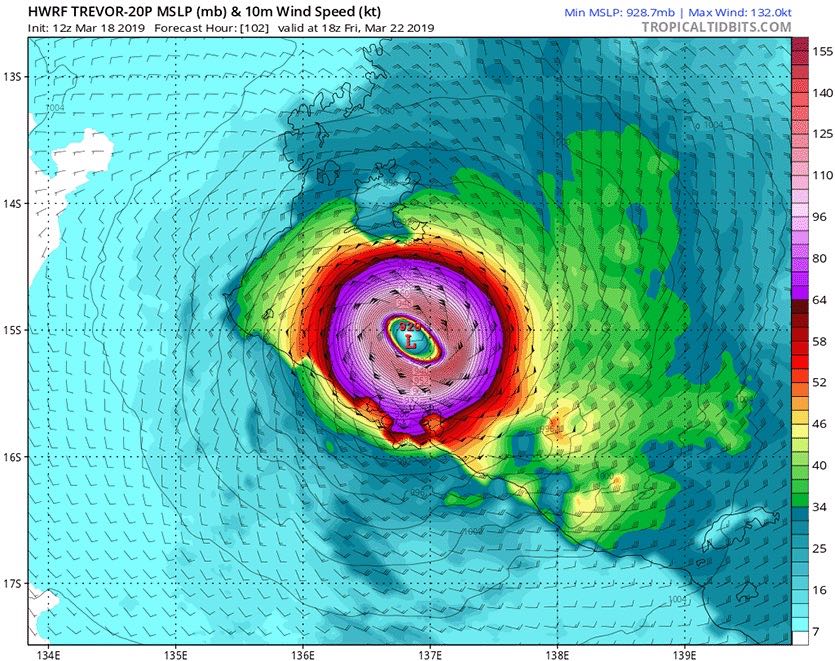
Trevor will weaken as it slogs across the cape over the course of about 24 hours, but another landfall—perhaps another intense one—appears quite possible as Trevor enters and traverses the Gulf of Carpentaria between Wednesday and Friday. SSTs are extremely warm in the gulf, running around 31-32°C (88-90°F)—up to 1°C above average for this time of year—and wind shear will remain very light. The last several runs of the HWRF model are in agreement that Trevor will reach at least Category 4 intensity before its second landfall on the northeast coast of Australia’s Northern Territory around Saturday local time. There are no sizable coastal towns in this sparsely settled area, where the Aboriginal population is widely dispersed in small communites.
 |
| Figure 1. Predicted surface winds (colors) at 18Z (2 pm EDT) Friday, March 22, 2019, from the 12Z Monday run of the HWRF model. The model predicted that Tropical Cyclone Trevor would be a Category 4 storm with 150-mph sustained winds, approaching landfall along the sparsely populated shore of Australia’s Gulf of Carpentaria. Image credit: tropicaltidbits.com. |
A rough analog to the projected dual landfalls of Trevor occurred in April 2006, when Tropical Cyclone Monica struck just south of Lockhart River with 100-mph sustained winds (according to JTWC) and then intensified dramatically across the Gulf of Carpentaria. Monica’s central pressure reached 916 mb, and peak 1-minute winds just before landfall were estimated at 180 mph by JTWC, the strongest on record for any Australian cyclone. Property damage was minimal, owing to the small population, but some 140 million trees were reportedly damaged or destroyed.
Jeff Masters contributed to this post.


