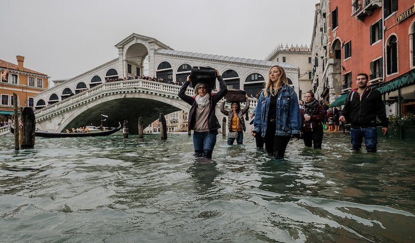
| Above: Tourists make their way along water-covered sidewalks near the famed Rialto Bridge in Venice, Italy, on Monday, October 29, 2018. High water levels forced schools and hospitals to close, and authorities advised citizens against leaving their homes. Image credit: Stefano Mazzola/Awakening/Getty Images. |
An exceptionally strong upper-level storm and low-pressure center has played havoc this week with the weather across large parts of Europe, especially Italy, where high winds, intense thunderstorms, and a landslide caused at least 11 deaths. Most of the fatalities were from falling trees as a powerful squall line ripped across the length of the Italian peninsula on Monday afternoon. One man died in a wind surfing accident off the coast of the Emilia-Romagna district, and a woman near Trento in northern Italy died after a landslide engulfed her home, according to the Associated Press.
Northwest of Rome, a wind gust to 202 km/hr (126 mph) was recorded on the island of Montecristo. This is just shy of the nation's record-high gust of 210 km/hr, according to independent weather researcher Maximiliano Herrera.
The costliest damage may have been on the Liguarian coast of western Italy, where close to 200 luxury yachts were reportedly destroyed in the port of Rapallo. Waves up to 10 meters (33 feet) high slammed into the marina, reported ANSA. The marina’s director said that a large section of a protective seawall gave way despite having been bolstered after a storm in 2000.
 |
| Figure 1. Destroyed yachts and boats lie in the harbour of Rapallo, near Genoa, on October 30, 2018, after a storm hit the region and destroyed part of a protective seawall the night before. Image credit: Marco Bertorello/AFP/Getty Images. |
The catalyst for the spate of extreme weather across Europe—including record October heat on one side of Switzerland followed by record October snow on the other—was a pronounced dip in the polar jet stream that extended across Spain well into northwest Africa. East of this cold upper-level trough, a strong flow of unseasonably warm air extended from northeast Africa all the way to Scandinavia. In between these contrasting air masses, an intense surface low moved from the Mediterranean across western Italy on Monday, accompanied by a cold front that spawned the bout of severe thunderstorms.
 at 12Z (7 am European time) Monday, October 29, 2018, across southern Europe, as analyzed by the GFS model") |
| Figure 2. Surface winds (in knots) at 12Z (7 am European time) Monday morning, October 29, 2018, across southern Europe, as analyzed by the GFS model. For wind speeds in miles per hour, multiply by 1.15. A strong surface low (982 mb) was located in the western Mediterranean, with very strong south to southeast winds lashing the west coast of Italy and pushing up the Adriatic Sea toward Venice. Image credit: tropicaltidbits.com. |
Venice’s worst “acqua alta” flooding in a decade
Some 70% of Venice was inundated on Monday by high water driven into the city’s lagoons by the circulation around the powerful surface low to the west. Venice is notorious for its “acqua alta” (high water) events, which periodically flood the renowned St. Mark’s Square and many of the city’s waterfront businesses and sidewalks. Acqua alta occurs when water is pushed lengthwise from south to north across the Adriatic Sea, parallel to Italy’s east coast. During such events, water naturally sloshes back and forth in the Adriatic over a 22-hour cycle, a phenomenon called a seiche. When this happens to be synchronized with the 24-hour astronomical tidal cycle, the seiche can accentuate the effects of an already-extreme weather-induced tide.
Much like king tides in Miami, acqua alta events are most common in autumn and winter, when astronomical tides are at their highest.
The video above shows participants in the Venice Marathon, who faced more than the usual challenges on Sunday, even before the city's flooding peaked. As reported by Runner's World: "Swaths of the course’s final leg were flooded with ankle-deep water, forcing participants, including the elite field, to splash their way to the finish. Heavy rain and a strong headwind didn’t help things, either." Organizers said conditions were the worst in the marathon's 32-year history.
The water level at the benchmark Punta della Salute recording site, located near the Salute Church just across from St. Mark’s Square, topped out at 156 centimeters (61.4 inches) above normal on Monday. This ties the level last observed in December 2008. In records going back to 1872, Venice has exceeded this water level only three times: February 1, 1986 (158 cm or 62.2”); December 22, 1979 (166 cm or 65.4”); and the devastating flood of November 4, 1966 (194 cm or 76.4”).
Tides in Venice are classified as “exceptional” when they exceed 140 cm (55.1"), which is enough to flood 59% of the city. According to City of Venice records, exceptional tides have occurred:
• only once from 1872 to 1950;
• about once every 5 to 10 years in the late 20th century;
• and—ominously—10 times in just the last two decades, including this week’s event.
When it comes to sea level, Venice faces a triple whammy: natural long-term sinking (subsidence) of the city, additional subsidence caused by human activity, and sea level rise due to human-caused climate change. The average water height in Venice has increased about 23 cm (9”) since 1897. Of that total, about 40% is attributable to sea level rise. The bulk of the remainder is from subsidence due to pumping of fresh water from an aquifer beneath the lagoon between the 1920s and early 1970s. See this 2008 post by Dr. Jeff Masters for more background on the factors that drive flooding in Venice.
 |
| Figure 3. The frequency of tidal flooding in Venice of at least 110 cm (43.3")—enough to inundate 12% of Venice—has ramped up from about once per decade in the early 20th century to once every three to eight weeks in the 2010s. Image credit: City of Venice. |
A controversial new tool in Venice’s battle with the rising sea
Italy has spent more than a decade working on a set of 78 hinged, inflatable steel gates to protect Venice from rising waters. The $7 billion US project is called MOSE (Modulo Sperimentale Elettromeccanico), in a tip of the hat to Moses’ parting of the Red Sea. Normally lying flat on the seafloor, the gates will be pulled up as needed in a 30-minute process that would block three inlets from the Adriatic and help keep the city safe from the increasingly threatening surges triggered by Mediterranean storms. MOSE is designed to be brought into service for any surge expected to exceed 110 cm (43.3"), a level that produces flooding across 12% of Venice. The gates are intended to handle surges of up to 200 cm (78.7" or 6.6 ft).
Originally due to be completed by 2011, MOSE has fallen prey to a series of technical snafus and management scandals—including the arrest and indictment of the mayor of Venice—that pushed the expected opening day back until at least 2022. In a 2017 investigative report, “Venice and MOSE: story of a failure,” the Italian newspaper La Stampa called the project an “anthology of horrors.”
Apart from its other woes, MOSE has a big Achilles’ heel: it won’t protect the city against the less extreme but more frequent floods (less than 110 cm) that will become more and more prevalent as subsidence and sea level rise continue. The 12% of Venice affected by such flooding includes some of the city’s most beloved and historic landmarks.
Yale's Environment 360 website has an excellent feature on the MOSE project and its travails, written by Jeff Goodell—author of the must-read book The Water Will Come: Rising Seas, Sinking Cities, and the Remaking of the Civilized World.


