| Above: Radar image of Barry at 9:10 am CDT July 13, 2019, from our wundermap. |
Designated as a hurricane for a scant three hours, Tropical Storm Barry was lashing the coast of southern Louisiana with storm surge and high surf on Saturday afternoon. Barry's biggest impacts are still to come—the torrential rains expected to move ashore and intensify later Saturday over parts of southeast Louisiana. Update (2 PM EDT): In an advisory at 2 pm EDT, the National Hurricane Center announced that Barry was making landfall near Intracoastal City, LA, with top sustained winds of 70 mph. Barry's center was located at 29.8°N, 92.1°W, at 2 pm EDT, and the storm was moving northwest at just 6 mph. In a tweet, NHC reported that Barry made landfall as a hurricane, presumably shortly before 2 pm, although no specific landfall time was given.
Barry was upgraded to minimal hurricane status at 11 am EDT Saturday, with top sustained winds of 75 mph. Barry's winds were estimated in the 69-75 mph range by the NEXRAD Doppler radar at Slidell, LA, and a station at Eugene Island reported sustained winds of 71 mph with a gust to 85 mph. Near this location, a reconnaissance flight also detected winds in the 69-73 mph range from the Stepped Frequency Microwave Radiometer. "Based on these data and the possibility that the strongest winds were not sampled, it is estimated that Barry became a hurricane around 11-12Z despite its less than classical appearance in satellite imagery," said forecaster Jack Beven in NHC's 11 am forecast discussion.
 |
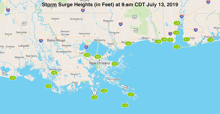
| Figure 1. Storm surge heights (in feet) measured at 9 am CDT July 13, 2019, as seen on the WU wundermap. Storm surge levels of 5' - 6' were being observed in central Louisiana south of Morgan City, and 3' - 4’ along the south shore of Lake Pontchartrain by New Orleans. |
Storm surge
Barry’s storm surge was nearing its peak on Saturday morning, with levels near 5’ along the south-central coast of Louisiana. The Louisiana State University storm surge viewer for Barry showed that the highest surge from Barry as of 10 am CDT Saturday was 5.9’ at LAWMA-Amerada Pass in south-central Louisiana.
 |
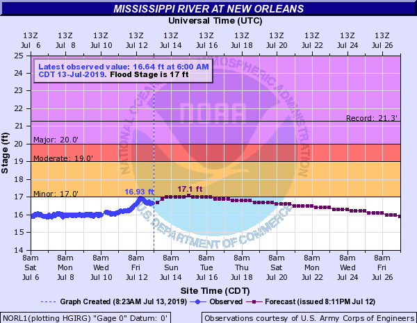
| Figure 2. Observed and predicted water levels along the Mississippi River at New Orleans at 8:23 am CDT Saturday, July 13, 2019. In a bit of good news, the MIssissippi River is no longer expected to overtop the levees in the city, which protect the city to flood heights of 20'. Image credit: NOAA. |
Mississippi River flooding no longer expected in New Orleans
Barry sent a storm surge up the Mississippi River towards New Orleans on Friday that peaked at 16.93’ above sea level—a full three feet below the tops of the levees, which protect the city to a river flood 20’ high. The Saturday morning forecast from NOAA’s Advanced Hydrologic Prediction Service has the river rising again due to predicted rainfall, but no higher than 17.1’ through early next week, so it appears New Orleans has dodged a major bullet. Earlier this week, forecasts called for the river to crest near 20’, right at the tops of the levees in New Orleans.
New Orleans still has to contend, though, with serious rainwater flooding that may result from the expected 5+ inches of rain expected to fall on the city over the coming three days.
Forecast for Barry
The official NHC forecast continues to bring Barry inland across southern Louisiana on Saturday afternoon, then northward across Louisiana and into Arkansas by Monday.
The heaviest rains from Barry are expected to pivot to its eastern quadrant on Saturday, with a north-to-south corridor of 10-15” amounts and pockets of 20-25” possible. This corridor will likely be east of Barry’s center, perhaps from around Morgan City to Baton Rouge, but the exact location of the heaviest rains will depend on mesoscale effects that are still difficult to pin down. Severe flash flooding is a distinct possibility wherever the heaviest rains set up. The NOAA/NWS Weather Prediction Center has placed much of southeast Louisiana in a high-risk area for excessive rainfall through Sunday morning.
Depending on how Barry evolves, very heavy rains could extend well north across the Mississippi Delta into parts of Mississippi and northeast Louisiana, with lesser but still-heavy amounts north of Barry's center from Arkansas into Missouri from Sunday into Monday.
River flooding will become an increasing concern as Barry slogs inland. At least one river—the Comite River near Comite Joor Road, in the northeast Baton Rouge area—is predicted to crest at record levels on Monday, according to a NOAA forecast issued Saturday morning. The forecast crest of 34.5 feet would top the 34.22 feet observed in the catastrophic flood of August 2016. Most other rivers in the area are predicted to fall short of the 2016 record crests.
Bob Henson co-wrote this post.


