| Above: Hurricane Lorenzo as seen by the MODIS instrument on NASA’s Terra satellite on Wednesday morning, October 2, 2019. At the time, Lorenzo was transitioning to an extratropical storm with Category 1-strength winds of 80 mph. Ireland and the UK are visible at upper right. Image credit: NASA. |
Hurricane Lorenzo roared past the western Azores Islands early Wednesday morning, passing 55 miles to the north of Flores Island at 2 am EDT Wednesday as a Category 1 hurricane with 90 mph winds. According to the National Hurricane Center (NHC), Lorenzo brought sustained hurricane-force winds to nearby Corvo Island: 74 mph winds, gusting to 101 mph. Winds of this strength have rarely been experienced in the Azores, and the Associated Press reported numerous downed trees and power lines. Azores Civil Protection Agency chief Carlos Neves said the main port on the island of Flores had suffered "grave damage" as part of the dock, the port's building and some cargo containers had been "swallowed" by the sea.
#FuracãoLorenzo #Lorenzo #Açores
— Meteo Trás-os-Montes (@MeteoOs) October 2, 2019
Alarmistas, diziam alguns!
Faial, 02.10.2019
Verónica Melo pic.twitter.com/s0p5r0PCx9
Some other wind gusts measured during Lorenzo’s passage
(courtesy of Jérôme Reynaud and NHC):
128 mph (206 km/h) at the Flores wind farm: unofficial value (private station, anemometer located in height, probably more than 10 m)
110 mph (177 km/h) at Lomba do Cácere (Pico Island)
107 mph (173 km/h) at Serra de Santa Bárbara (Terceira Island)
101 mph (163 km/h) at Corvo [IPMA station] (Corvo Island)
100 mph (161 km/h) at Pico do Alandroal (São Jorge Island)
90 mph (145 km/h) on Faial Island
88 mph (142 km/h) on Flores Island
70 mph (110 km/h) at Horta in the central Azores
At 11 am EDT Wednesday, Lorenzo had completed the transition to an extratropical storm, and was no longer a hurricane. Ex-Lorenzo was racing northeast at 43 mph towards Ireland with Category 1 hurricane-strength winds of 80 mph, and satellite imagery showed that Lorenzo had lost its tropical characteristics. Sea surface temperatures were a chilly 20°C (68°F) and were steadily falling as Lorenzo zoomed northeastward.
Forte houle au passage de l'#ouragan #Lorenzo ce mercredi sur l'archipel des #Açores. Illustration à Ponta Delgada (île de São Miguel, Est Açores) via Instagram >> https://t.co/111K401Tyw pic.twitter.com/gjUZMS8WEd
— Météo Villes (@Meteovilles) October 2, 2019
Ex-Lorenzo was an unusually large storm, with hurricane-force winds that extended outwards up to 150 miles from the center. Along the storm’s eastern semicircle—the side that will affect Ireland—tropical storm-force winds spanned an area over 730 miles in diameter. This huge wind field has created large waves over a vast region of ocean; NHC estimated that 12-foot-high waves spanned a region over 1500 miles in diameter (from northwest to southeast of the center) in their 11 am EDT Wednesday advisory.
Near the center of ex-Lorenzo, the significant wave heights (mean wave height of the highest third of the waves) were analyzed to be nearly 50 feet on Wednesday morning by the WaveWatch 3 model; individual extreme waves could have easily approached 100 feet in height. Large swells from Lorenzo were affecting most of the North Atlantic, bringing the risk of dangerous rip currents and high surf to the U.S. East Coast, Canadian maritime provinces, the coast of Western Europe, The Bahamas, and the north-facing coasts of the islands of the northeast Caribbean.
 |
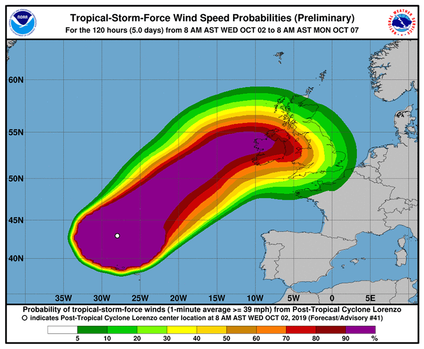
| Figure 1. Probability of sustained winds of tropical storm strength (39 mph) along the track of ex-Lorenzo as predicted at 11 am EDT Wednesday, October 2, 2019. Ireland and the UK lie in the predicted path of ex-Lorenzo. Image credit: NHC. |
Forecast for Lorenzo: watch out, Ireland!
Ex-Lorenzo is expected to weaken only slowly before reaching Ireland, bringing sustained 70 mph winds (just below Category 1 strength) to the northwest coast of the nation on Thursday night. Ex-Lorenzo is expected to bring sustained tropical storm-force winds in excess of 39 mph to portions of the UK by Friday morning. The WaveWatch 3 model predicts waves with a significant wave height of up to 35 feet high along the offshore waters of Ireland on Thursday afternoon and evening.
The Irish Meteorological Service has issued an “Orange Alert” wind warning for the entire western coast of Ireland for the storm; in northwest Ireland, heavy rains in excess of 2” are capable of causing some flood concerns. The rest of the nation is under a “Yellow Alert” for high winds.
Azores hurricane history
Over the past 50 years, 20 named storms have tracked through the Azores, including four Category 1 hurricanes, according to NOAA’s Historical Hurricane Tracks website. None of these storms did significant damage, according to EM-DAT (the international disaster database) and National Hurricane Center storm summaries. There was just one fatality from these storms: Tropical Storm Bonnie, which killed one person in the Azores in 1992.
The deadliest Azores storm was a 1946 Category 1 hurricane that killed 27 people in the islands, according to EM-DAT. The strongest Azores hurricane was hurricane #8 of 1926, which made landfall on São Miguel island near Ponta Delgada while at peak Category 2 strength (105-mph winds). On January 15, 2016, Hurricane Alex—the Atlantic’s first January hurricane in more than 60 years—struck Terceira island as a high-end tropical storm. In October 2017, Ophelia passed well south of the Azores as a Category 3 hurricane, producing tropical storm-force winds in the islands, according to the NHC's final report.
Elsewhere in the Atlantic
In their 8 am EDT Wednesday Tropical Weather Outlook, NHC called attention to an Atlantic disturbance with 2-day and 5-day odds of development of 10% and 20%, respectively: a broad area of low pressure over the Western Caribbean that was bringing a small amount of disorganized heavy thunderstorm activity to the region. The disturbance had support for development from about 10 – 20% of the 70+ members of the 0Z Wednesday GFS and European model ensemble forecasts, and was predicted to move west-northwest into the southern Gulf of Mexico by Friday. A similar level of support was being given for development early next week of a tropical wave predicted to move off the coast of Africa on Friday, but NHC has not yet included that system in their Tropical Weather Outlook.
Huge loss for the weather community: NOAA’s Bill Lapenta
Atmospheric scientists around the U.S. and beyond were in grief and shock this week after the unexpected death of William (Bill) Lapenta on Monday in a drowning accident while on vacation in the Outer Banks of North Carolina. Rough surf and a rip current may have been a factor, according to OBX Today, citing a release from the Town of Duck.
Formerly a director of the NOAA/NWS National Centers for Environmental Prediction, Lapenta had been serving as the acting director of the Office of Weather and Air Quality at NOAA Research. Before joining NOAA in 2008, Lapenta spent two decades at NASA's Marshall Space Flight Center, where he was deputy manager of the Science and Exploration Research Office and an adjunct professor at the University of Alabama in Huntsville.
 |
| Figure 2. Bill Lapenta. Image credit: Louis Uccellini. |
“The unthinkable has happened,” said NWS director Louis Uccellini in an email to NWS staff on Tuesday. “Bill was a friend to us all. He was a world-renowned scientist, a leader in weather modeling, an amazing partner and collaborator, an energetic mentor, and a devoted husband and father.”
Lapenta was one of the prime leaders of the effort to establish the Earth Prediction Innovation Center (EPIC), a major NOAA initiative to infuse the agency’s weather and climate modeling activities with expertise from across the weather enterprise.
Bob Henson contributed to this post.
Bill Lapenta was a genuine, caring person who believed in the missions of NOAA and NWS. He cared about his people, he truly wanted to understand what we needed and how he could move us forward. A visionary, a true leader. He will be greatly missed. https://t.co/tXHT6BUwPv
— Elizabeth Leitman (@WxLiz) October 1, 2019


