| Above: Hurricane Lorenzo at 9:40 am EDT September 30, 2019. At the time, Lorenzo was a Category 2 storm with 105 mph winds. Image credit: NOAA/RAMMB. |
Hurricane warnings are flying for the central and western Azores Islands for Hurricane Lorenzo. At 11 am EDT Monday, Lorenzo was speeding north-northeast at 15 mph towards the Azores as a Category 2 hurricane with 105 mph winds.
Lorenzo is an unusually large hurricane, with a hurricane-force wind field 170 miles in diameter. Along the hurricane’s eastern semicircle—the side that will affect the Azores—tropical storm-force winds span an area nearly 500 miles in diameter. This huge wind field has created large waves over a vast region of ocean; NHC estimated that 12-foot high waves spanned a region 900 miles in diameter at 11 am EDT Monday. Near the center of Lorenzo, the significant wave heights (mean wave height of the highest third of the waves) were estimated by the WaveWatch 3 model to be nearly 50 feet. Individual extreme waves could reach double that height--100 feet high.
#Lorenzo is forecast to send enormous waves toward the Azores and Western Europe- with a peak significant wave height of ~50 ft (15m), some individual waves will likely be near 100 feet! pic.twitter.com/n8s8cjypa0
— Eric Blake(@EricBlake12) September 30, 2019
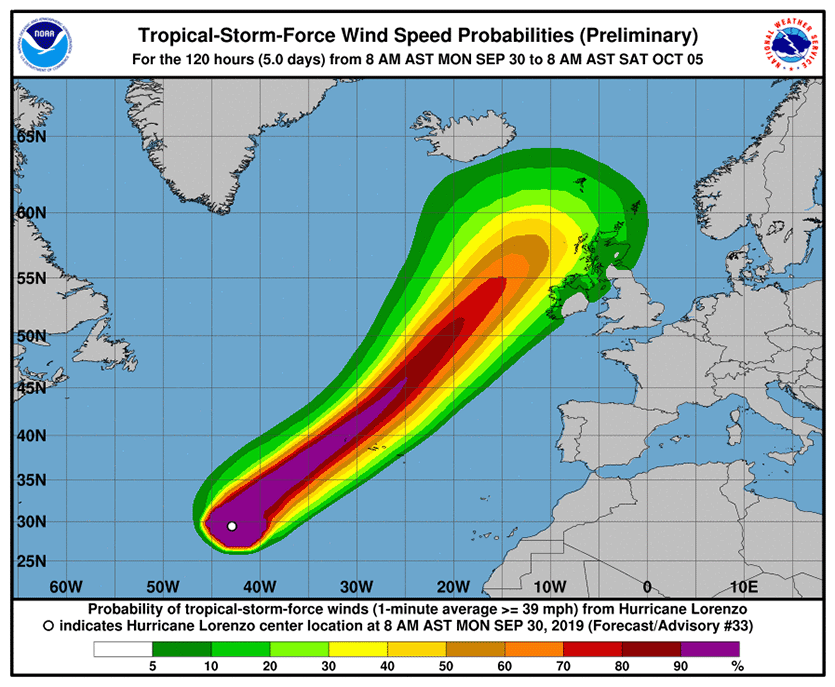
Lorenzo will begin affecting the Azores on Tuesday night, and pass near the northwesternmost Azores islands, Corvo and Flores, early on Wednesday. Together, these islands hold only about 4500 of the Azores’ 250,000 residents. NHC predicts that these islands have about a 30-40% chance of getting peak winds of hurricane strength and a greater-than-90% chance of tropical storm-force winds. However, the hurricane’s vast size means that many parts of the Azores could experience potentially damaging tropical storm-force winds. Heavy rains of 2 – 4”, capable of causing destructive flash flooding, are expected in the western Azores.
Lorenzo is expected to weaken only slowly before reaching the Azores, arriving as a Category 1 or 2 hurricane with winds of 85 – 95 mph. After the hurricane passes the islands, wind shear, dry air, and cold ocean waters will cause Lorenzo to transition to a hurricane-strength extratropical storm. The long-range path of ex-Lorenzo has great uncertainty, and it is possible that it could bring tropical storm-force winds to portions of the U.K. and Ireland on Thursday evening and Friday.
 |
| Figure 1. Probability of sustained winds of tropical-storm strength (39 mph) along the track of Lorenzo as predicted at 11 am EDT Monday, September 30, 2019. The northwesternmost Azores islands of Corvo and Flores lie closest to the predicted path of Lorenzo. Portions of the UK and Ireland have at least a 20% chance of tropical storm-force winds. Image credit: NHC. |
Azores hurricane history
Over the past 50 years, 20 named storms have tracked through the Azores, including four Category 1 hurricanes, according to NOAA’s Historical Hurricane Tracks website. None of these storms did significant damage, according to EM-DAT (the international disaster database) and National Hurricane Center storm summaries. There was just one fatality from these storms: Tropical Storm Bonnie, which killed one person in the Azores in 1992.
The deadliest Azores storm was a 1946 Category 1 hurricane that killed 27 people in the islands, according to EM-DAT. The strongest Azores hurricane was hurricane #8 of 1926, which made landfall on São Miguel island near Ponta Delgada while at peak Category 2 strength (105-mph winds). On January 15, 2016, Hurricane Alex—the Atlantic’s first January hurricane in more than 60 years—struck Terceira island as a high-end tropical storm. In October 2017, Ophelia passed well south of the Azores as a Category 3 hurricane, producing tropical storm-force winds in the islands, according to the NHC's final report.
Per NOAA's historical database, only 7 Cat. 2+ #hurricanes have tracked within 200 nautical miles of the #Azores. We'll see if #Lorenzo will maintain at least that intensity next week. pic.twitter.com/oY4vSOJy7S
— Jonathan Erdman (@wxjerdman) September 27, 2019
One dead, 10 missing, and 3 saved from ship that sank in Lorenzo
Three survivors from a tugboat that sank near the center of Hurricane Lorenzo on Thursday were rescued on Saturday with the help of NOAA Hurricane Hunters. On Monday, NBC reported that a search aircraft had located one body, and ten others were still missing from the 162-foot long Bourbon Rhode tugboat, which was en route from the Canary Islands to Guyana. On Friday, a NOAA plane heading out to collect data on the record-breaking storm in the eastern Atlantic Ocean was diverted to the search. "At the request of the U.S Coast Guard, NOAA 43 … was asked to investigate the last known positions of search and rescue satellite hits for the vessel," Jonathan Shannon, a spokesman for NOAA's Office of Marine and Aviation Operations, told weather.com Friday afternoon.
The Bourbon Rhode is one of three ships to sink in Atlantic hurricanes this decade. On October 1, 2015, the cargo ship El Faro sank in Hurricane Joaquin in The Bahamas; all 33 crew members perished. On October 29, 2012, the replica sailing ship Bounty sank off the coast of North Carolina in Hurricane Sandy. Two people died in the tragedy, and 14 were rescued.
 |
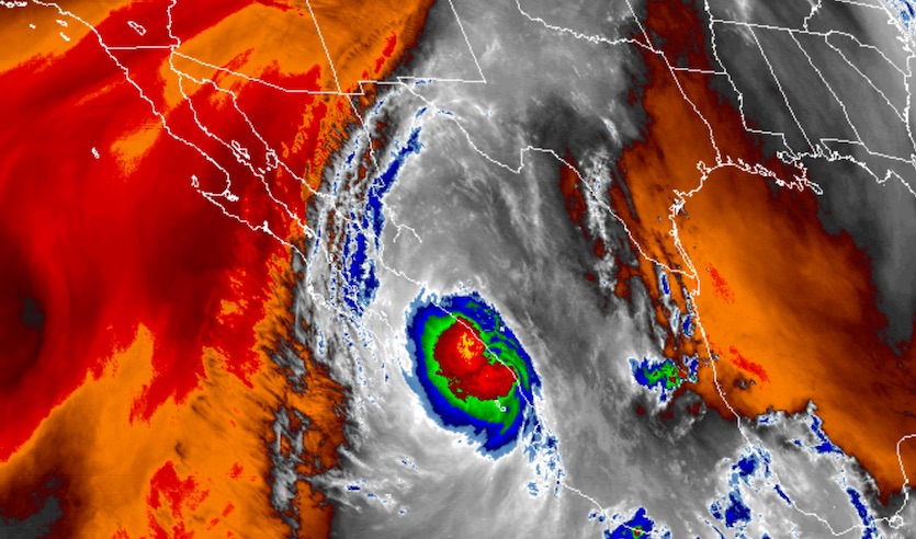
| Figure 2. Satellite image showing mid-level water vapor surrounding Tropical Storm Narda, which was hugging the west-central coast of Mexico, at 1520Z (11:20 am EDT) Monday, September 30, 2019. Moisture extends from the vicinity of Narda into the U.S. Southern Plains. Image credit: RAMMB/CIRA/CSU. |
Narda churns toward the Gulf of California; moisture sweeping into U.S.
Tropical Storm Narda is grinding its way up the west coast of Mexico towards the Gulf of California. Narda was upgraded to minimal tropical-storm status at 11 am EDT Monday after having weakened to a depression on Sunday afternoon. Narda’s low-level center was about 50 miles south of Mazatlan, heading northwest at 15 mph. Most of Narda’s showers and thunderstorms were clustered well offshore, but some of the convection was moving just inland.
Narda is predicted by NHC to hug the east side of the Gulf of California as it continues northwestward. This will limit any potential strengthening over the very warm waters along its track. The European model ensemble from Sunday night agrees with the NHC outlook, while the GFS ensemble favors a more leftward track that would take Narda across the Gulf to central Baja California by Wednesday. The difference in track angle is minor, but the GFS solution would keep more of Narda over water for a longer period. Either way, Narda will eventually be snuffed out by increasing wind shear, drier mid-level air, and land interaction.
A channel of mid- and upper-level tropical moisture is already streaming from the vicinity of Narda into the U.S. Southern Plains. This moisture will enhance showers and thunderstorms along a front draped from the Plains into the Midwest. A strip of 2-4” rains could develop from eastern New Mexico into Kansas, Nebraska, and Iowa; flash flood watches are in effect for parts of each state. Later this week, the remaining moisture from Narda’s remnants will push into eastern Arizona and New Mexico.
My rental car this morning on Great Falls, Montana. #snowstorm pic.twitter.com/sfqAlQizhF
— Tyler Corder (@tcordervegas) September 29, 2019
Incredible September snow in Northwest U.S.
The central U.S. front that will intercept moisture from Narda is associated with a powerful upper low that produced record-smashing snowfall over the weekend in the Northern Rockies. A storm total of 48 inches was reported Sunday night in Browning, Montana, by the Blackfeet Nation Emergency Operation Center. Other phenomenal totals for September included 37” at Dupuyer Creek and 28” at East Glacier. All-time record storm totals for September were reported on Sept. 28-29 at several locations, including Spokane, Washington (3.3”, topping 1.4” from Sept. 23, 1926) and Great Falls, Montana (19.3”, topping 13.2” from Sept. 23-24, 1934). The two-day total in Great Falls is also the city's second highest for any time of year, behind only 24.2" on April 27-28, 2009.
Bob Henson co-wrote this post.


