| Above: WU depiction of NWS Doppler radar image of Tropical Storm Karen at 1712Z (1:12 pm EDT) Tuesday, September 24, 2019. |
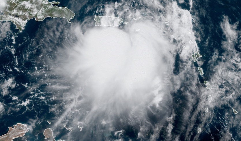
Puerto Rico, the British and U.S. Virgin Islands, and nearby smaller islands are in for a prolonged dousing from Tropical Storm Karen from Tuesday into Wednesday. Tropical storm warnings are in effect as Karen approaches, and as of 11 am EDT Tuesday, Karen’s top sustained winds were 40 mph--at the low end for a tropical storm. The predominant low-level center of Karen—which was embedded near the north end of a broader zone of low pressure—was located about 65 miles south-southeast of San Juan, Puerto Rico, or about 35 miles offshore from the territory’s southeast coast. However, a hurricane hunter center fix at 11:56 am EDT reported that the center had relocated near a clump of heavy thunderstorms about 30 miles to the southwest of the 11 am position
 |
| Figure 1. GeoColor satellite image of Tropical Storm Karen at 1630Z (12:30 pm EDT) Tuesday, September 24, 2019. Image credit: RAMMB/CIRA/CSU |
Karen was moving north at about 8 mph, a track that will bring the bulk of Karen’s heavy thunderstorms and squalls across Puerto Rico and the Virgin Islands from Tuesday afternoon into early Wednesday. A personal weather station on St. Croix in the U.S. Virgin Islands recorded 3.30” of rain from Karen as of 1 pm EDT Tuesday. Showers and storms may persist through Wednesday, well after Karen moves north of the islands, given that the storm’s southern half is packing more moisture, and assuming that Karen could intensify on Wednesday. Localized rains could top 8” across eastern Puerto Rico, Vieques and Culebra, and the Virgin Islands. Flash floods and mudslides will be a distinct possibility. Karen's rains will be welcome along most of the southern coast of Puerto Rico, though, which is in moderate to severe drought.
Long-range outlook for Karen
Both the track and intensity forecasts for Karen beyond about three days are fraught with more uncertainty than usual. As an upper-level low near the Bahamas backs westward, Karen’s main steering influence later this week will be a sprawling upper-level high—unusually strong for late September—predicted to develop from the Southeast U.S. into the Northwest Atlantic. This high will wrap around Karen’s east and north sides, which will prevent the storm from taking a typical recurvature path toward the north and northeast. NHC is predicting that Karen will stall around Friday and embark on a slow west-southwest motion over the weekend.
 |
| Figure 2. WU depiction of official NHC forecast for Karen at 11 am EDT Tuesday, September 24, 2019. |
Looking at the 0Z Tuesday runs of our three top operational track models, the UKMET and European models bring Karen on a westward track roughly similar to the NHC forecast, with the UKMET on the slower side, while the GFS dissipates Karen, as do nearly all of the GFS ensemble members from 0Z Tuesday. Most of the European ensemble members keep Karen active well into next week, but with a wildly varying set of tracks. More than a week from now, some Euro members have Karen heading toward Cuba or the U.S. East Coast; some have Karen recurving; and others keep Karen becalmed well out in the Northwest Atlantic.
Karen’s intensity down the line is also riddled with question marks. It will be tough for Karen to consolidate until it moves north of Puerto Rico on Wednesday. Wind shear is predicted to drop into the light to moderate range (around 10 knots) from Wednesday into the weekend. At the same time, subsidence on the southeast side of the building upper high will generate a large pool of dry air to the northwest of Karen. Karen’s ultimate fate may depend on whether it can wall off a moist central core by late this week. If so, the relatively light wind shear will help keep dry air from infiltrating. Warm sea-surface temperatures of 28-29°C (82-84°F) east of the Bahamas will lend support to Karen. NHC is predicting that Karen will gradually intensify to near hurricane strength by Saturday.
 |
| Figure 3. Tropical Storm Jerry to the west-southwest of Bermuda at 10:52 am EDT September 24, 2019. At the time, Jerry had top winds of 60 mph. Image credit: tropicaltidbits.com. |
Tropical Storm Jerry headed towards Bermuda
A Tropical Storm Warning is up for Bermuda as Tropical Storm Jerry heads north at 7 mph towards the island. At 11 am EDT Tuesday, Jerry was located 285 miles west-southwest of Bermuda, with top winds of 60 mph. Heavy rain showers from Jerry’s outer bands were already affecting the island, as seen on Bermuda radar. Update: Jerry's top winds were reduced to 50 mph in the 2 pm EDT update from NHC.
Satellite loops late Tuesday morning showed that Jerry was struggling with moderate wind shear and cool sea surface temperatures near 26°C (79°F). Jerry’s low-level circulation center was exposed to view, and there was limited heavy thunderstorm activity. Jerry’s appearance was more like a subtropical storm than a tropical storm, with the heaviest thunderstorms in a band well-removed from the center. With cool SSTs, dry air, and moderate to high wind shear expected over the next four days, Jerry is likely to slowly weaken and become post-tropical late this week.
Jerry is predicted to take a turn to the northeast towards Bermuda on Tuesday night. On this track, Jerry is likely to pass less than 100 miles to the northwest of Bermuda on Wednesday morning. At that time, tropical storm-force winds are predicted to extend out about 150 miles to the northeast of Jerry’s center, and the 11 am EDT Tuesday wind probability forecast from NHC gave Bermuda a 40% chance of experiencing tropical storm-force winds. NHC is calling for storm-total rainfall amounts of 1 – 3” on the island.
Jerry will be the second named storm to affect Bermuda in the past week; on September 18, Hurricane Humberto passed just to the northwest of the island as a Category 3 hurricane with 120 mph winds. Humberto’s powerful right-front eyewall passed over Bermuda, bringing it sustained hurricane-force winds and knocking out power to about 80% of the island. The Bermuda airport recorded sustained winds of 82 mph, gusting to 116 mph, at the height of the storm, and the Bermuda Maritime Operations Centre (at an elevated location) recorded a wind gust of 144 mph. No injuries or major damage were reported in Bermuda.
 |
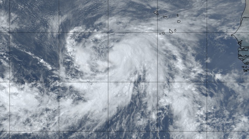
| Figure 4. GeoColor satellite image of Tropical Storm Lorenzo at 1555Z (11:55 am EDT) Tuesday, September 24, 2019. Image credit: tropicaltidbits.com. |
Lorenzo set to intensify in the eastern Atlantic
Tropical Storm Lorenzo took a pause in its strengthening over the eastern tropical Atlantic on Tuesday, with top winds holding at 65 mph as of 11 am EDT Tuesday. Lorenzo is still expected to become an intense hurricane by late this week, perhaps reaching Category 3 strength. Lorenzo will be a large hurricane as well. Lorenzo’s tropical-storm-force winds already extend nearly 140 miles northeast of the center; by the weekend, these winds are predicted to span an area more than 300 miles in diameter.
Wind shear will remain light to moderate (5 – 10 knots) along Lorenzo’s path into the weekend, with SSTs of 27-28°C (81-82°F) sufficient to keep the storm fueled. Global track models are in close agreement on a classic recurvature path into an upper-level weakness to be carved out in part by Tropical Storm Jerry. Lorenzo should be no threat to land, but it may be a spectacular hurricane on satellite by later this week.
Moisture from Lorena feeds severe weather in Arizona
Severe thunderstorms with heavy rain riddled Arizona on Monday, causing pockets of flash flooding. A CoCoRaHS station measured 3.81” through early Tuesday near Tonto Basin, and 2-3” amounts were widespread across Maricopa County, including the Scottsdale area. Yuma picked up 0.51”, a substantial chunk of its 3.34” annual average (1981-2010). Several roads in the Phoenix area remained closed on Tuesday morning.
The storms were triggered by an infusion of low- and mid-level moisture from former Hurricane Lorena together with a compact upper-level low centered in the lower Colorado River valley. Additional moisture from former Hurricane Mario, close on Lorena’s heels, will continue to fuel storminess in Arizona.
Easy to pick out the upper low center this morning, near Yuma. The low should hardly move the next couple of days, extending rain chances through Thursday. Rain will be focused across SE AZ today. Better chances for storms back in the Valley Wed and Thu. #azwx #cawx pic.twitter.com/FN6Re9sUS1
— NWS Phoenix (@NWSPhoenix) September 24, 2019
Tropical Cyclone Hikka makes landfall in Oman
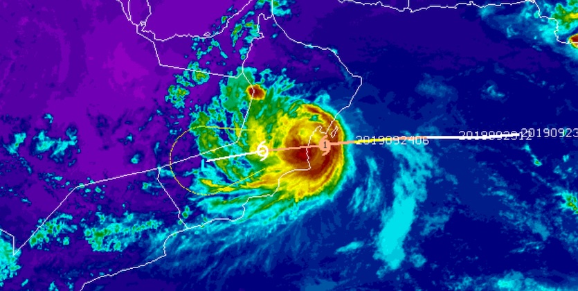
Cyclone Hikaa made landfall between 6 and 7 pm local time Tuesday night on the arid coast of eastern Oman near Duqm, according to the Indian Meteorological Department. A couple of hours earlier, at 8 am EDT Tuesday, the Joint Typhoon Warning Center (JTWC) had pegged Hikaa’s top sustained winds at 85 mph—Category 1 hurricane strength. Hikaa was a tiny cyclone, with hurricane-force winds extending only about 15 miles from the small center. At 6:25 pm local time Tuesday (10:25 am EDT), the Duqm airport recorded sustained winds of 52 knots (60 mph) gusting to 67 knots (77 mph).
 |
| Figure 5. Infrared image of Cyclone Hikaa at 1500Z (7 pm local time and 11 am EDT) Tuesday, September 24, 2019, shortly before Hikaa made landfall near Duqm, Oman. Image credit: CIMSS/SSEC/UW-Madison |
Oman typically gets a tropical cyclone landfall once every year or two, based on reliable statistics going back to the 1970s. Nearly all of these cyclones arrive well below hurricane strength. Cyclone Phet struck far eastern Oman with top sustained winds estimated by JTWC at 120 mph on June 3, 2010, inflicting 24 deaths and causing $780 million in damage (2010 USD). Cyclone Gonu, the most destructive tropical cyclone on record to strike Oman, reached Category 4 strength in the Arabian Sea and came ashore as a Category 1 storm on June 6, 2007. Gonu caused $4 billion in damage (2007 USD) and took 50 lives. Most recently, on May 25, 2018, Cyclone Mekunu made landfall as a borderline Cat 2/3 storm in far southern Oman. Mekuno left $1.5 billion in damage (2018 USD) in Yemen, Oman, and Saudi Arabia, and caused 31 deaths. Damages from Hikaa may be limited by its small size and by the lack of higher terrain near its landfall location that could boost rainfall totals.
Jeff Masters contributed to this post.


