| Above: Workers intentionally sink a barge in Bayou Chene, Louisiana in May 2011, in order to block backwater flooding triggered by the opening of the Morganza Spillway. Image credit: USACE. |
After the wettest winter in U.S. history brought the Mississippi River to its second-highest flood on record in Louisiana on March 17, renewed spring rains over the past two months in the Central Plains and Midwest brought the river to its fourth-highest crest on record on Sunday. However, the flood has fallen just short of the level that would force the Army Corps of Engineers to open the Morganza Spillway in Louisiana to prevent its overtopping and potential failure.
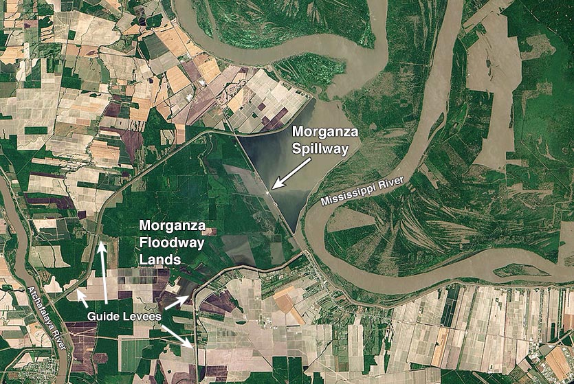
The Morganza Spillway, completed in 1954, is one of three flood-control diversion structures on the Mississippi River built in the wake of its catastrophic 1927 flood. When the gates of the structure are opened, water flows westward through farmland between two guide levees into the Atchafalaya River. Valuable farmland and several hundred structures lie in the floodway, and up to $2 billion worth of property is at risk of flooding if the spillway is opened to its full capacity.
 |
Figure 1. Satellite view of the Morganza Spillway on May 15, 2011, one day after the spillway had been operated to relieve record flooding on the Mississippi River. Operation of the spillway allowed flood waters from the Mississippi River to flow through the structure into farmlands along the Morganza Floodway. The flood was confined by guide levees to force the water into the Atchafalaya River (left side of image). Flooding in the floodway was limited to the farmlands immediately adjacent to the spillway in this image, but later reached all the way to the Atchafalaya River. Image credit: NASA Earth Observatory via Getty Images. |
The first five months of 2019 were the wettest January-to-May period in U.S. history, causing billions of dollars in flood damage that is still unfolding. It was originally expected that the Morganza Spillway would have to open on June 2, but the predicted arrival of the flood crest from the Arkansas River—which set all-time flood records along a 150-mile stretch from eastern Oklahoma to western Arkansas—was delayed, due to the breaching and overtopping of multiple levees. This allowed the flood waters to spread out and slow down.
 |
Figure 2. River hydrograph for the Mississippi River at Red River Landing, Louisiana. The river crest on Sunday at 61.27’ above sea level, the fourth-highest flood on record since the modern levee system was constructed in 1928. Image credit: NOAA. |
Fourth-highest flood on record on Lower Mississippi
The Mississippi River at Red River Landing near the Morganza Spillway crested on June 16 at 61.27’, its fourth-highest flood on record. Remarkably, back on March 17, the river had its second-highest crest on record: 61.98'. Four of the five highest floods on record at Red River Landing have come in the past nine years, including the record flood, 63.4’, which occurred in May 2011—the last time the Morganza Spillway was opened. When the river exceeds 62', the flood waters overtop the gates of the structure and cascade down the other side, potentially creating scour holes that might undermine the structure and cause its permanent failure.
As explained in our detailed May 2019 three-part post on the Old River Control Structure, If the Old River Control Structure Fails: A Catastrophe With Global Impact, the higher flood heights along this part of the Mississippi River in recent years are due to human engineering of the river channel. These changes have caused more sedimentation and contricted the river channel, forcing higher flood heights.
 |
| Figure 3. Predicted flood depths on June 28, 2019 along the Atchafalaya River in Louisiana if the Morganza Spillway is opened at a flow rate of 30,000 cfs. Image credit: USACE Atchafalaya River interactive flood mapping tool |
Intentionally sinking a barge to block flooding
When the Morganza Spillway is opened, a large volume of water flows into the Atchafalaya River and causes major flooding problems downstream. The flood waters rise so high near Morgan City, Louisiana that the water backs up into several tributaries of the Atchafalaya, forcing them to reverse their flow direction. This “backwater flooding” has been affecting portions of three Louisiana parishes since May. The Atchafalaya hit 8.5 feet at Morgan City on June 6, the third highest crest on record and the highest since May 2011.
In response to this backwater flooding and the anticipated opening of the Morganza Spillway, on May 29, Louisiana’s Coastal Protection and Restoration Authority intentionally sank a 400-foot long oceangoing barge to block the flow of water in Bayou Chene, near Morgan City. Water flowing around the barge was then closed off by June 4 with sheet metal, steel beams and rocks. This engineering fix, done at a cost of $7 million, has effectively blocked backwater flooding up Bayou Chene and lessened flooding in the town of Amelia (population 2500) and other locations. The sinking of a barge in Bayou Chene was also performed during the floods of 2011 and 2016. A permanent structure to prevent backwater flooding on Bayou Chene has received $75 million in funding from the state of Louisiana, and there are plans to build it in 2021.
Massive run-off expected to create second-largest Gulf of Mexico dead zone on record
The massive amount of fresh water this year’s Mississippi River flood has emptied into the Gulf of Mexico has carried huge amounts of fertilizers and nutrients scoured from the vast area of the U.S. (plus a little bit of Canada) in the great river’s drainage basin. When they reach the warm waters of the Gulf of Mexico, these nutrients create giant algae blooms that rob the ocean of oxygen, creating a “dead zone” hostile for marine life. NOAA predicts that this year’s dead zone will be around 7800 square miles—about the size of the state of Massachusetts. Since dead zone measurements began in 1985, the only larger one came in 2017, when runoff from heavy spring rains created an 8776 square-mile dead zone.
Considering that this year’s flood has been much greater than 2017’s, it is quite possible that the models being used to forecast the 2019 dead zone are underpredicting it, said Don Scavia, professor emeritus at the University Michigan, Ann Arbor’s School for Environment and Sustainability in an interview with Sierra magazine.
Fresh water damage to Mississippi and Louisiana fisheries
The unprecedented double flood peak on the Mississippi River—in March, then again in May/June—forced the first-ever double opening of the gates of the Bonnet Carré Spillway in St. Charles Parish, Louisiana to allow flood waters from the swollen Mississippi River to flow into Lake Pontchartrain. As of June 11, 168 of the 350 bays of the spillway remained open.
The massive amount of fresh water flowing into the Gulf of Mexico waters of Mississippi and Louisiana from the opening of the spillway is causing havoc for sea life that requires salt water to survive. According to clarionledger.com, a 60% loss of oysters has occurred in the Gulf waters of Mississippi, and a 36% loss of crabs. The fresh water may also be contributing to an unusually high mortality rate for dolphins—128 dead dolphins were documented as of June 7, a figure higher than the toll from the 2010 BP oil spill.
 |
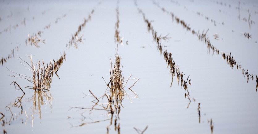
| Figure 4. Rows of farmland near Holly Bluff, Miss., are covered with backwater flooding, in this May 23, 2019, photo. Normally there would be cotton or corn or soybean crops in the rows. U.S. Senator Cindy Hyde-Smith, R-Miss., sent a letter on June 12 to President Trump to approve the use of temporary pumps in the Yazoo Backwater Area to begin removing floodwaters that have contaminated the region for months on end. Image credit: AP Photo/Rogelio V. Solis. |
Backwater flooding a major problem in west central Mississippi
Further upstream, backwater flooding related to the Steele Bayou Control Structure has inundated a vast area east of the Mississippi River toward Yazoo City, Mississippi. At Vicksburg, MS, the Mississippi has been above flood stage for nearly four months—the longest span since the castastrophic flood of 1927. Some flooding occurs in this area almost every year, but this year's inundation has been unusually widespread and prolonged, with more than half a million acres under water and more than 500 homes affected by months of flooding. The high waters are not expected to recede until at least July. Mississippi Today has extensive coverage of the Yazoo Backwater flooding and its impacts.
Bob Henson contributed to this post.


