| Above: Enhanced infrared image of Hurricane Rosa as of 1835Z (2:35 pm EDT) Sunday, September 30, 2018. Image credit: tropicaltidbits.com. |
Hurricane Rosa is weakening quickly due to high wind shear and cool waters as it steams northwards at 13 mph towards the northern portion of Mexico’s Baja Peninsula. Rosa’s top winds were down to 75 mph at 11 am EDT Sunday, a shadow of its Category 4 winds of 145 mph on Thursday.
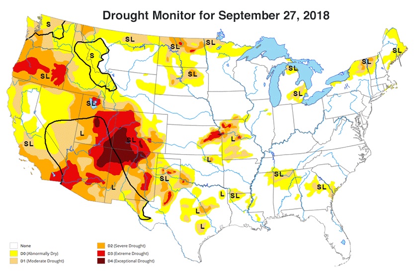
Mexico has been very fortunate this season, with only one landfalling tropical storm so far—Tropical Storm Bud, which made landfall near the tip of the Baja Peninsula on June 14. That luck will change on Monday evening, when a weakening Rosa is expected to hit northern Baja California as a low-end tropical storm, bringing rainfall amounts of 3 – 6” and the threat of flash flooding and mudslides. Models indicate a tongue of rich moisture will shoot into the California/Arizona border region beginning on Monday, then spread into much of the Desert Southwest on Tuesday. This moisture will be capable of generating heavy rains of 2 – 4” capable of causing dangerous flash flooding. On the positive side, the entire Southwest is in drought, so Rosa’s rains will do much to ease the drought conditions there.
 |
| Figure 1. Precipitable water (PW, the amount of moisture in the air above a given point) will be unusually rich across the Southwest on Tuesday morning, running from 4 to 6 standard deviations above average for the time of year. PW values could reach 1.5” in the atmosphere over Las Vegas and 2.0” over Yuma. These would both set records for the highest values observed in any month from October through June. A separate zone of high PW will be moving into coastal Southern and Central California on Tuesday. Image credit: tropicaltidbits.com. |
 |
| Figure 2. U.S. drought conditions as of September 27, 2018. Rosa’s heavy rains will be falling over regions in moderate to extreme drought. Image credit: USDA/University of Nebraska-Lincoln/NOAA. |
A separate zone of heavy rain, triggered by an offshore midlatitude storm helping to steer Rosa, will dump 1 – 3” of rain over parts of the Southern and Central California coast and foothills on Tuesday and Wednesday. Here, too, the showers and thunderstorms will be a mixed blessing: they will help reduce the autumn fire threat, but rains falling atop burn scars from 2017 could lead to localized flash flooding.
Some of Rosa’s upper-level energy and moisture will get all the way to the Midwest by midweek, where it could help feed downpours in Minnesota and Wisconsin—including places still trying to dry out after torrential rains in August and September.
An unusually northerly landfall
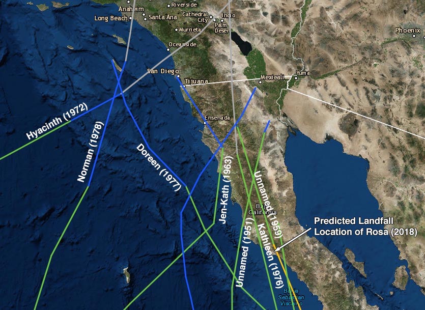
Rosa will make landfall at an unusually far north location on Mexico’s Baja Peninsula: near 29.5°N latitude, or about 200 miles south-southeast of San Diego. Since accurate record keeping began in 1949, just three tropical storms have made landfall along the west coast of the Baja Peninsula at a more northerly latitude than that: Tropical Storm Kathleen of 1976, Tropical Storm Jen-Kath in 1963, and an unnamed storm in 1951. Unusually warm sea surface temperatures (SSTs), about 1 – 2°C (1.8 – 3.6°F) above average, will help allow Rosa to maintain tropical storm strength to such a northerly latitude. Note that we do have records of two tropical cyclones that have hit California: the 1939 California tropical storm, which hit Long Beach, and the 1858 San Diego hurricane.
 |
| Figure 3. Tracks of all tropical cyclones to make landfall or pass just offshore of the northern Baja Peninsula since 1949. The mostly northerly landfall by a tropical storm on the western Baja Peninsula since 1949 was at 31°N latitude, by Tropical Storm Jen-Kath in 1963. The mostly northerly landfall by a hurricane was by an unnamed 1959 Category 1 hurricane. Note that these stats do not include the 1939 California tropical storm, which hit Long Beach, and the 1858 San Diego hurricane. Image credit: NOAA/CSC. |
Sergio and Walaka form in the Eastern and Central Pacific
Two new named storms formed in the Eastern and Central Pacific over the weekend—Tropical Storm Sergio, which was located about 480 miles south of Manzanillo, Mexico at 11 am EDT Sunday, and Tropical Storm Walaka, which was located about 770 miles south-southwest of Honolulu, Hawaii, at 11 am EDT Sunday. Both Sergio and Walaka are expected to become Category 3 hurricanes later this week, but neither will affect any land areas this week.
Sergio and Walaka add to the high storm tallies of the very busy 2018 hurricane season in the Eastern Pacific, which now has had 19 named storms, 10 hurricanes, and 7 intense hurricanes. An average season has 15 named storms, 8 hurricanes, and 3 intense hurricanes, so we are well past those benchmarks with several more weeks of prime hurricane season remaining. The all-time records in the Northeast Pacific are 27 named storms (set in 1992), 16 hurricanes (set in 2015, 2014, and 1992), and 11 intense hurricanes (set in 2015). Rosa is the seventh Category 4 hurricane of the 2018 eastern Pacific Hurricane Season, tying the record recently set in 2015.
 |
| Figure 4. Infrared-wavelength image of Tropical Storm Leslie as of 1815Z (2:15 pm EDT) Sunday, September 30, 2018. Image credit: NASA/MSFC Earth Science Branch. |
Leslie to spin across Central Atlantic all week (and perhaps beyond)
Tropical Storm Leslie promises to be a long-lived system in the remote Central North Atlantic. Leslie began as a subtropical storm last Sunday, then got swallowed up by a midlatitude cold front and was reclassified by the National Hurricane Center (NHC) as a post-tropical cyclone on Tuesday. After it escaped the influence of that front and drifted south over warm waters, Leslie was reborn as a subtropical storm on Friday. It was reclassified yet again on Saturday evening, this time as a full-fledged tropical storm.
Leslie’s top sustained winds were 50 mph as of 11 am Sunday. Leslie is a large system for its modest strength, with tropical-storm-force winds extending out up to 205 miles from its center. Strong westerly wind shear of 25 – 30 knots was pushing dry air into the storm and keeping showers and thunderstorms (convection) shunted mainly toward the east side of Leslie, with the low-level center exposed at times. Wind shear is projected to decrease to around 10 -15 knots for several days beginning late Monday, though. Steering currents will remain quite weak, allowing Leslie to drift slowly southwest toward warmer waters. The slow motion will allow for upwelling of cooler water that may counteract Leslie’s drift toward warmer SSTs.
With the balance of factors in Leslie’s favor, NHC predicts that Leslie will become a hurricane by Wednesday. Around that point, a weak impulse in the midlatitude jet stream may start to tug Leslie northeastward. Longer-range models suggest that the impulse won’t be enough to recurve Leslie completely, though, and Leslie could end up posing a threat to the Azores more than a week from now.
Swells from Leslie of up to 6 feet will be affecting the East Coast throughout the coming week. Small craft advisories were in effect on Sunday from Florida to North Carolina.
We’ll have a full update on the Northwest Pacific in our next post, including Typhoon Trami—which swept across Japan on Sunday, causing dozens of injuries—and fast-growing Typhoon Kong-Rey, the next threat for East Asia. See the weather.com feature for more on Friday night's horrific earthquake and tsunami that killed hundreds of people on the Indonesian island of Sulawesi.
Dr. Jeff Masters co-wrote this post.


