| Above: Surfers leave the water next to Scripps Pier on Thursday, Aug. 2, 2018. Image credit: AP Photo/Gregory Bull. |
A locally intense heat wave atop long-term warming has pushed the San Diego area into atmospheric and oceanic territory unseen in human memory. The first ten days of August have seen overnight lows hovering in record territory night after night. Meanwhile, the surface of the Pacific Ocean near San Diego is warmer than anything observed in more than a century of recordkeeping.
Because this is a marine climate, temperature variations tend to be small, which means even a modest amount of warming can be historically significant. And once the sea surface temperatures (SSTs) get into record-warm territory, they will tend to keep the atmosphere above them unusually warm (and vice versa) until a pattern shift occurs.
Just north of San Diego, at the Scripps Institution of Oceanography, SSTs have been measured at Scripps Pier daily since 1916, making this one of the longest series of SSTs collected anywhere on Earth. The pier saw its all-time highest SST on August 1 with 78.6°F (25.9°C), beating the 78.4°F (25.8°C) set on July 30, 1931.
This new record was promptly eclipsed on August 3 with 78.8°F (26.0°C). In turn, that record was trampled on Thursday (Aug. 9) with 79.5°F (26.4°C)—a reading more than 1°F higher than anything observed before this summer.
 |
| Figure 1. Sea surface temperatures at Scripps Pier have nudged beyond anything recorded in 102 years of measurements. The shaded area depicts the highest and lowest SSTs observed since 1916 on each day of the year. The all-time high set on August 1 was exceeded on August 3, with an even higher reading of 79.5°F (26.4°C) on August 9. Image credit: SIO and California State Parks. |
September heat arrives in August
The atmospheric records this month have been no less impressive. San Diego’s Lindbergh Field has tied or broken its warmest daily minimum on every day in August thus far (Aug. 1-9) except for Aug. 7, a remarkable streak for any location. No morning since July 28 has dipped below 72°F, whereas the city’s average high in early August is 76°F.
On Thursday, the low of 77°F was the warmest for any August in 144 years of San Diego recordkeeping. Friday could even top that, as the morning low was 79°F. If that reading holds till midnight, which is quite possible, it will be the warmest daily minimum in San Diego weather history, beating the 78°F observed on Sept. 9 and 17, 1984, and on Sept. 11, 2015. Update (August 12): San Diego's official low on Friday, August 10, was 78°F, matching the all-time warmest daily low. The city set yet another daily record-warm low on Saturday, August 11, with 77°F, and a record is virtually certain for Sunday as well.
“In most of our ‘bad summers,’ September is the warmest,” said Matt Moreland, meteorologist in charge at the National Weather Service office in San Diego. “August is completely off the charts so far.”
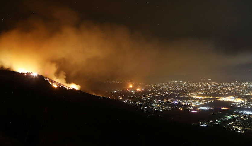
Record warmth across California has paved the way for wildfire season to get an early start. Just north of San Diego County, more than 20,000 people have been urged to evacuate ahead of the Holy Fire, which had burned 18,173 acres as of Friday morning.
 |
| Figure 2. The Holy Fire burns on Thursday night, August 10, 2018 near Lake Elsinore, California. Image credit: Mario Tama/Getty Images. |
A glitch in the oceanic A/C
The upper-level warmth dominating the Southwest U.S. this summer has played a role in this string of records, but the ocean is clearly in the driver’s seat. The Pacific circulation normally pushes warm surface water away from the California coast, allowing much cooler subsurface waters to upwell via the California Current. That’s why it’s often possible to get chillier taking a summer dip off San Diego than on the much-further-north Jersey Shore.
This summer, it’s remained seasonably cool along most of the California coast—downtown San Francisco has been running 1-2°F below average since late July—but unusually light winds have allowed the upwelling to slacken south of Los Angeles, which in turn has left surface waters free to warm up in the intense low-latitude sun.
“June to September is when the coast north of Santa Barbara experiences maximal upwelling,” said Clarissa Anderson, executive director of the Southern California Coastal Ocean Observing System, in an email. “We see that in the negative temperature anomalies that the central/northern California coast is experiencing right now.”
 |
| Figure 3. Sea surface waters at Scripps Pier (La Jolla, California) have been monitored and analyzed since 1916. Image credit: Scripps Oceanography, @scripps_ocean. |
Why have warm lows been more notable than warm highs in San Diego?
There have been a few daily record highs in the San Diego mix this month, including 85°F on both Aug. 2 and 3, and 91°F on Aug. 7—but San Diego has been known to get as hot as 111°F (Sept. 26, 1963). The reason that this August’s record-warm lows have been more persistent than the record-warm highs has to do with the unique aspects of the California coast. The lowest half-mile or so of the coastal atmosphere—called the marine layer—is dominated by Pacific air, which tends to keep lows and highs from straying too far from the ocean temperature.
Record highs are much more likely on those occasions when strong weather features push hot, dry inland air over the coastal ranges and into seaside communities, especially from late summer into autumn. A variation of this pattern helped produce the blazing temperatures of July 6 across coastal and inland Southern California, including UCLA’s hottest temperature in 85 years of recordkeeping: 111°F.
When will it break?
It wouldn't take too much to get upwelling going again, said Scripps professor Dan Rudnick. "The ocean is very stratified right now, with a thin layer of warm water at the surface." At a depth of 50 meters (165 feet), he noted, water temperatures are near average for this time of year. "So there is plenty of cool water not very deep, and as soon as the wind picks up, I would expect the surface water to cool quickly." This might occur as soon as Saturday afternoon near the immediate coast, Rudnick said.
Temperatures may dip slightly across the San Diego area early next week, as high pressure weakens and the marine layer deepens. Even so, temperatures will remain up to 5°F above average, with lows in the neighborhood of 70°F. Long-range models show the high pressure rebuilding later next week, perhaps for an extended period.
“The worry is that this ridge becomes as ‘ridiculously resilient’ as the one that helped maintain the Pacific warm anomaly in 2014–2016 [aka “the Blob”] and led to the prolonged drought in California that we are arguably still experiencing,” said Anderson.
 |
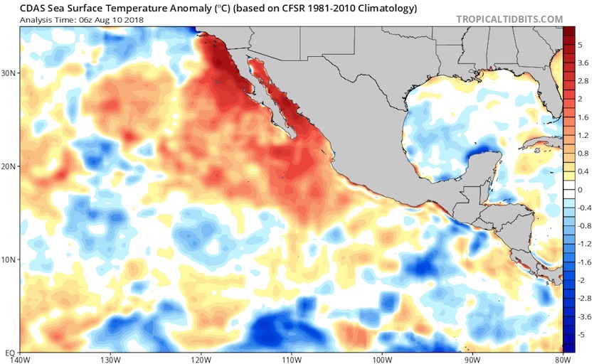
| Figure 4. Model-analyzed departures from the average sea surface temperature observed at this time of year from 1981 to 2010 (in degrees C) as of Friday, August 10, 2018. Image credit: tropicaltidbits.com. |
The oceanic warmth extends well beyond the immediate San Diego area. SSTs have been running 1-2°C above average across a broad area extending south and east from Southern California to the west coast of Mexico, as well as westward all the way to Hawaii and across a large zone of the far northeast Pacific extending into the Gulf of Alaska. Readings have also soared to 32°C (90°F) or more over large parts of the Gulf of California. Although long-term records are sparse for the Gulf of California, these readings are at least 2°C warmer than the 30°C (86°F) values that prevail during late summer.
The overall fingerprint of warmth in the northeast Pacific this summer is consistent with the positive phase of a pattern dubbed the Pacific Meridional Mode, which can sometimes (but not always) weaken the Pacific’s trade winds and help encourage El Niño to develop. (For much more about the PMM, see this entertaining climate.gov explaner by expert Dan Vimont from 2016, “Your eight-minute speed date with the Pacific Meridional Mode”.)
Implications for the Northeast Pacific hurricane season
As long as they persist, the unusually warm waters will give a boost to any tropical storms or hurricanes that move northwest close to the Mexican coast and/or into the Gulf of California. The Northeast Pacific has seen 11 named storms this year, compared to the average through August 10 of 7.5, and the amount of accumulated cyclone energy is 76% above normal, according to statistics maintained by Colorado State University.
As it happens, the most spectacular heat wave in San Diego history—five days over 95°F, with three of those over 100°F, all of them daily records that still stand—occurred on Sept. 18-22, 1939. Three days later, the only tropical storm to make landfall in modern California history moved northward and struck near Long Beach, bringing torrential rains and high winds and causing dozens of fatalities.


