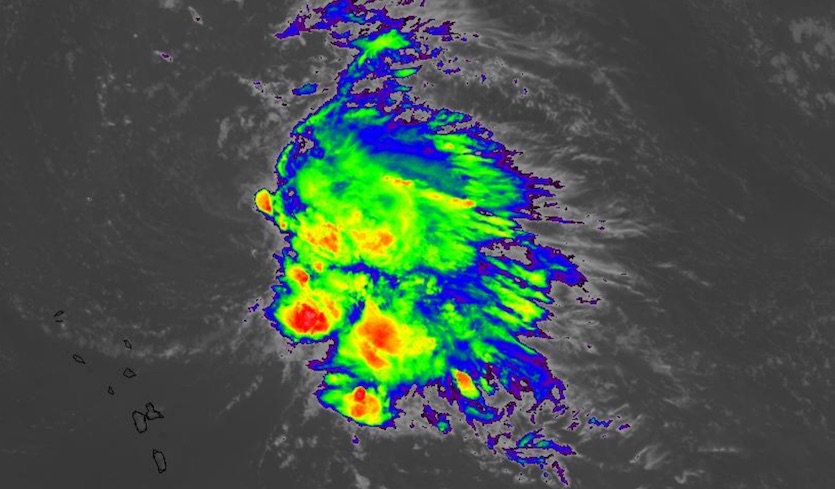
| Above: GeoColor satellite image of Tropical Storm Sebastien at 1640Z (11:40 am EST) Tuesday, November 19, 2019. A low-level swirl can be seen on the northwest edge of Sebastien’s cloud shield, revealing how westerly shear is pushing Sebastian’s showers and thunderstorms east of its center. Image credit: RAMMB/CIRA/CSU. |
The Atlantic tapped us on the shoulder Tuesday morning with the formation of Tropical Storm Sebastien, reminding us that hurricane season isn’t over for a couple more weeks. The disturbance formerly known as 90L was designated Sebastien at 11 am EST Tuesday, with top sustained winds of 45 mph. Sebastien was located almost 300 miles northeast of the Leeward Islands, moving north-northwest at 8 mph over open waters.
The disturbance that became Sebastien had been tracked by NHC’s Tropical Weather Outlook since Saturday. Long-range models had pointed toward some development for days, and showers and thunderstorms (convection) had become increasingly organized, with surface winds strengthening. However, there was no evidence of the closed circulation required for a tropical cyclone until an ASCAT scatterometer pass on Tuesday morning suggested a tiny closed low was present.
 |
| Figure 1. Infrared satellite image of Tropical Storm Sebastien at 1650Z (11:50 am EST) Tuesday, November 19, 2019. Image credit: NASA/MSFC Earth Science Branch. |
Sebastien is a highly asymmetric tropical storm. Nearly all of its convection at midday Tuesday was on the east side of its circulation, the result of strong westerly wind shear (20 – 25 knots) pushing dry air into the circulation. Sea surface temperatures near Sebastien of around 28°C (82°F) are warm enough to support development, and roughly 0.5°C above average for this time of year.
After drifting slowly north-northwest for the next day or two, Sebastien will get swept up into a strong midlatitude front and upper-level trough moving off the U.S. East Coast, pushing the storm toward the northeast. It’s quite possible Sebastien will take on subtropical characteristics as it interacts with the front and trough and as wind shear increases further. Sebastien’s winds may actually increase as it moves toward its ultimate fate as an extratropical frontal low. With no land masses in its immediate path, Sebastien will pose no problems for any populated areas while it remains a named storm.
 |
| Figure 2. Surface (black lines) and 500-millibar (shaded bands) forecast from the 12Z Tuesday, November 19, 2019, run of the GFS model, valid at 24 hours (7 am EST Wednesday) and 60 hours (7 pm EST Thursday). The GFS predicts that Sebastien will be swept up into a midlatitude upper-level trough and front later this week. Image credit: tropicaltidbits.com. |
Jeff Masters on Sebastien’s role in the 2019 Atlantic season
Dr. Jeff Masters, who now pens the Eye of the Storm blog for Scientific American, provides us with some climatological perspective on our latest Atlantic storm.
“Sebastien’s formation gives the Atlantic 18 named storms for the season—pretty rare territory, since only 8 other seasons since 1851 have had 18 or more named storms. Since storms began getting names in 1950, the only Atlantic named storms beginning with “S” have been Sebastien (1995), Stan (2005), Shary (2010), Sean (2011), and Sandy (2012). Both Stan and Sandy had their names retired.
“Sebastien’s formation brings the Atlantic tally for 2019 to 18 named storms, 6 hurricanes, 3 intense hurricanes, and an ACE index of 124.1. The 1981 – 2010 averages for these quantities by November 19 were 11.6 named storms, 6.2 hurricanes, 2.7 intense hurricanes, and an ACE index of 102.3, according to Dr. Phil Klotzbach, so 2019 is near or above average in all metrics.”
In an Atlantic season largely divided into weak systems and powerhouses, we can safely expect Sebastien to fall into the first group. Each of this year’s 18 named storms to date has peaked as either a tropical storm or a major hurricane, except for Category 1 Barry and Pablo and Category 2 Jerry. Many of this year’s systems have also been quite short-lived. Eight of them have lasted 48 hours or less, the largest number in any season except for the nine in 2007, according to Klotzbach. Seven of those have lasted just 24 hours or less, breaking the record of six set in 2005. We’ll see if Sebastien hangs on long enough to avoid falling into either group.


