| Above: Twin trouble: Tropical Cyclone Veronica and Tropical Cyclone Trevor spin in the waters north of Australia in this Himawari-8 image taken at 5Z Thursday, March 21, 2019. Image credit: NOAA/RAMMB. |
Twin tropical cyclones, Veronica and Trevor, are headed towards landfall along Australia’s north coast on Friday or Saturday. Both could be major Category 3 storms at landfall.
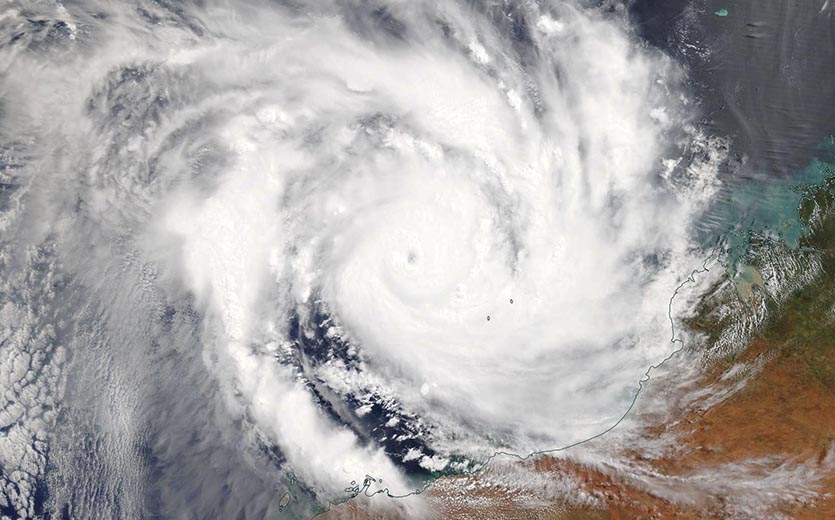
The more intense storm at 12Z Thursday was Tropical Cyclone Veronica, which the Joint Typhoon Warning Center (JTWC) rated a Category 4 storm with 130 mph winds. Australia’s Bureau of Meteorology (BOM), which uses a separate rating system, had Veronica at roughly the same intensity, and with a 938 mb pressure.
Veronica underwent a phenomenal period of rapid intensification on Wednesday, taking advantage of low wind shear and very warm sea surface temperatures (SSTs) near 30°C (86°F)—up to 1°C above average for this time of year. Veronica intensified from a tropical storm with 65 mph winds at 6Z March 20 into a Category 4 storm with 145 mph winds just 18 hours later—an 80 mph increase in winds. The National Hurricane Center considers rapid intensification to be a 35-mph increase in winds in 24 hours, so Veronica blew past that threshold.
 |
| Figure 1. MODIS satellite image of Tropical Cyclone Veronica taken Thursday morning, March 21, 2019. Image credit: NASA. |
Forecast for Veronica
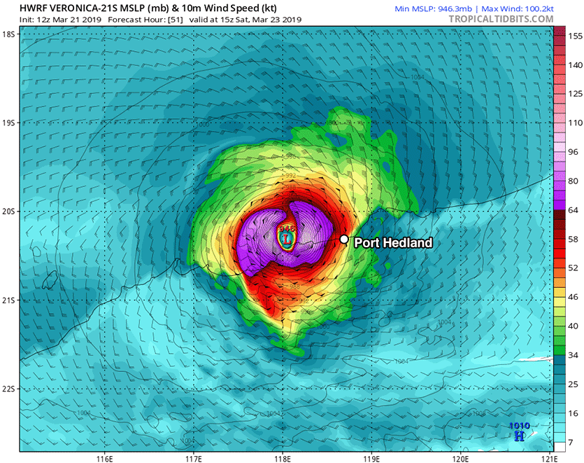
Higher wind shear of 10 - 15 knots helped weaken Veronica by Thursday morning, and the storm will see a slow increase in wind shear as it heads southwest at 3 mph towards the coast. The higher wind shear should be able to drive dry air from continental Australia into the core of Veronica, causing weakening as the storm nears the coast on Saturday. On Saturday, steering currents will weaken, and it is not guaranteed that Veronica will make landfall. Given the storm’s slow motion as it approaches the coast, very heavy rainfall amounts in excess of 500 mm (20”) are possible through early next week. Western Australia is not heavily populated, and the largest town in the region near Veronica’s expected landfall point is Port Hedland (population 14,000).
 |
| Figure 2. Predicted surface winds (colors) at 15Z (11 am U.S. EDT) Saturday, March 23, 2019, from the 12Z Thursday, March 21, 2019 run of the HWRF model. The model predicted that Tropical Cyclone Veronica would be a low-end Category 3 storm with 115-mph sustained winds, approaching landfall in western Australia near Port Hedland. Image credit: tropicaltidbits.com. |
Trevor headed towards a second Australia landfall
Tropical Cyclone Trevor made landfall in northeast Australia’s Queensland province near 07 UTC Tuesday as a Category 3 storm with 115 mph winds, according to the Joint Typhoon Warning Center (JTWC). Trevor was the first major tropical cyclone to hit Queensland since Nathan of 2015, which struck as a Category 3 storm with 115 mph winds on March 19, 2015.
Trevor made landfall just south of the town of Lockhart River (population 600), where wind gusts of up to 83 mph (133 km/hr) were measured. Lockhart River was on the less intense side of Trevor’s clockwise circulation. The cyclone caused considerable damage to trees and a few buildings, and up to 300 mm of rain (11.81”) fell along its path across the sparsely populated Cape York Peninsula.
 |
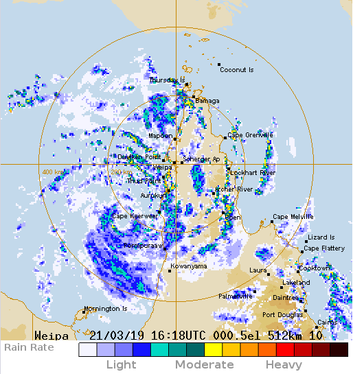
| Figure 3. Radar image of Tropical Cyclone Trevor at 12:18 pm U.S. EDT March 21, 2019. Image credit: Australia BOM. |
At 12Z Thursday, Trevor was moving slowly south-southwest at 6 mph over the warm waters of Australia’s Gulf of Carpentaria. JTWC rated Trevor a tropical storm with 60 mph winds, while the BOM rated Trevor as being the equivalent of a minimal-strength Category 1 hurricane with 75 mph winds and a central pressure of 982 mb. SSTs are extremely warm in the gulf, running around 31°C (88°F)—up to 1°C above average for this time of year—and the water has a high heat content, in excess of 100 kilojoules per square centimeter. Wind shear will remain mostly light through landfall, 5 - 15 knots. All of these conditions are favorable for intensification. Trevor grew disorganized after its trek over the Cape York Peninsula on Tuesday and Wednesday, but is now looking well-organized on satellite and radar, so we should anticipate a period of rapid strengthening beginning Thursday night and extending into Friday.
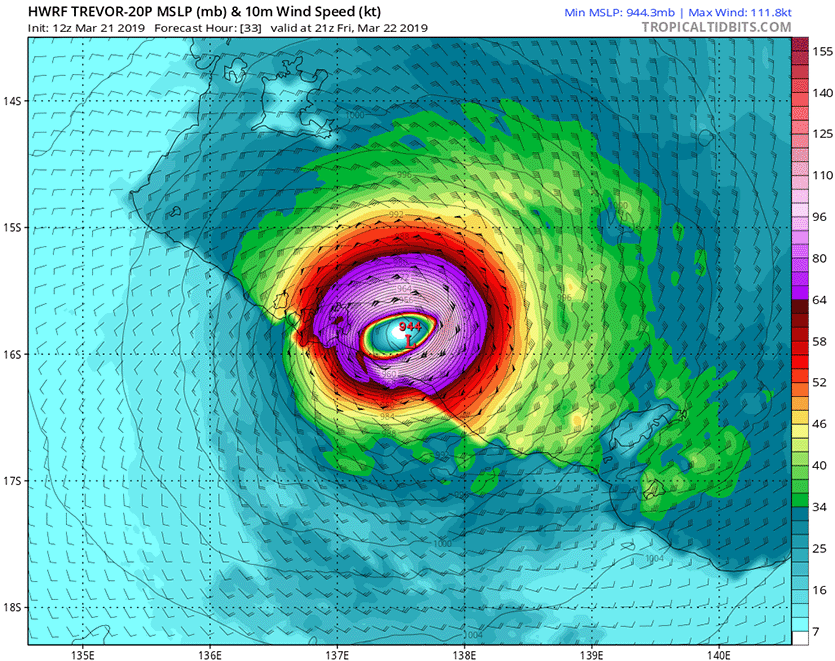
The JTWC expects Trevor to be a Category 1 storm with 90 mph winds when it makes its final landfall on Friday evening (U.S. EDT) along the northeast coast of Australia’s Northern Territory, while the BOM predicts a much stronger storm—a Category 3 with winds near 125 mph and a central pressure of 940 mb. Recent runs of the HWRF model support more intensification than JTWC is calling for, and Trevor is likely to be a Category 3 cyclone with 115 – 125 mph winds at landfall.
Fortunately, there are no sizable coastal towns in the sparsely settled area where Trevor is expected to come ashore. The Aboriginal population is widely dispersed in small communities in the region.
 |
| Figure 4. Predicted surface winds (colors) at 21Z (5 pm U.S. EDT) Friday, March 22, 2019, from the 12Z Thursday run of the HWRF model. The model predicted that Tropical Cyclone Trevor would be a high-end Category 3 storm with 125-mph sustained winds, approaching landfall along the sparsely populated northeast coast of Australia’s Northern Territory. Image credit: tropicaltidbits.com. |
Michael and Florence retired from the Atlantic list of hurricane names
The World Meteorological Organization (WMO) announced on Wednesday that the names Michael and Florence had been retired from the Atlantic list of storm names. Category 4 Michael did $17 billion in damage and killed 32 people after making landfall in the Florida Panhandle; Category 1 Florence dumped all-time record-breaking rains over North Carolina and South Carolina, and was responsible for 53 deaths and $15 billion in damage. The names Francine and Milton will appear in 2024 to replace Florence and Michael.
An interesting note pointed out by Craig Ceecee: with the retirement of Florence, all the original "F" names from the 1979-84 series have been retired from circulation (Frederic, Frances, Floyd, Florence, Felix, and Fran). It's the first letter to lose all its original names to retirement.


