
Above: A disaster management volunteer carries a sick child as villagers on the Bay of Bengal coast are evacuated as a precaution against Cyclone Amphan at Bakkhali, West Bengal, India, on Tuesday, May 19, 2020. (AP Photo/Mehaboob Gazi)
Tropical Cyclone Amphan contined barreling through the northern Bay of Bengal en route to an expected landfall Wednesday evening local time on the coast of eastern India. Amphan’s top winds will be considerably weaker at landfall than during its Category 5 peak strength earlier this week, but the cyclone is still more than capable of delivering a highly destructive storm surge to parts of eastern India and Bangladesh.
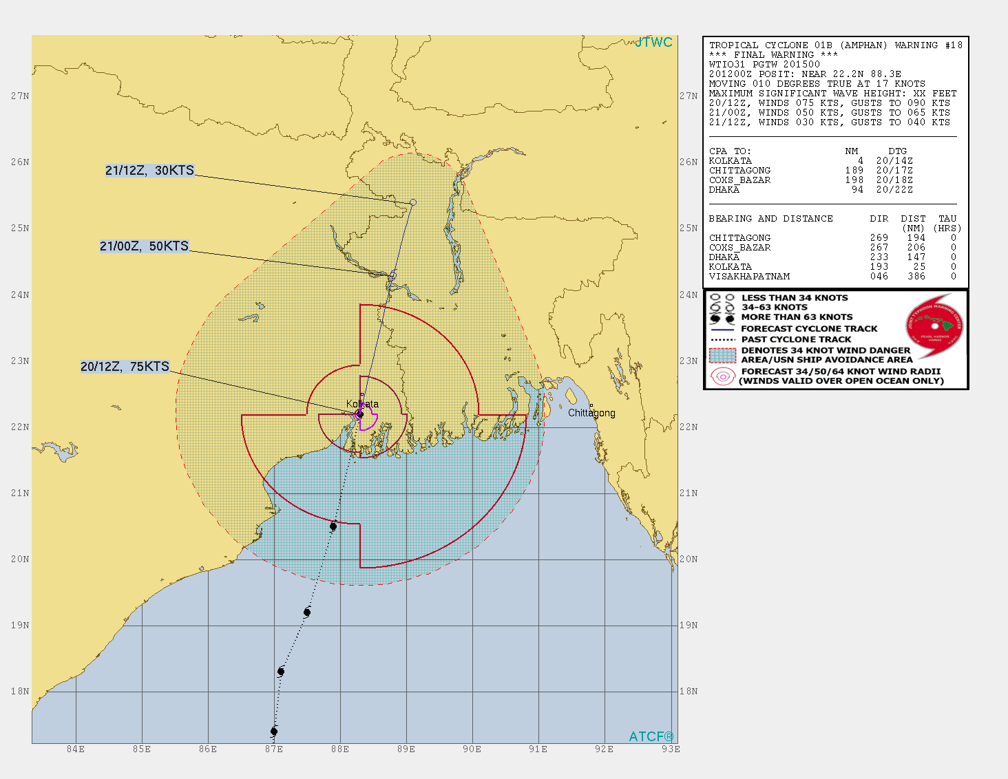
As of 12Z (5:30 pm IST) Tuesday, the Joint Typhoon Warning Center placed the center of Amphan about 370 miles south-southwest of Kolkata, moving just east of due north at about 10 mph. JTWC estimated Amphan’s top sustained (1-minute) winds at 100 knots (115 mph), making it a low-end Category 3 storm.
Amphan has taken a battering from mid-level dry air and wind shear, including an unusually strong surge of southeasterly winds several miles above the surface that was poorly handled by forecast models. Through it all, this large cyclone has remained well structured, although the eyewall was open at 12Z Tuesday and the eye was no longer distinct on satellite imagery.
Wind shear will remain in the 20-30 knot range until landfall, and with the left side of Amphan experiencing increased land interaction over time, the center of Amphan is likely to come ashore at no more than Category 2 strength. As of 15Z Tuesday, the Indian Meteorological Department (IMD) predicted Amphan would have 3-minute sustained winds of 85 knots (100 mph) at landfall, which would correspond to somewhat higher winds on the 1-minute scale used for hurricanes. JTWC projected a Category 1 landfall, with top 1-minute winds of 70 knots (80 mph).
Amphan’s storm surge threat will remain higher than one might guess from these forecasts of landfall strength. Amphan has been pushing a tremendous amount of water northward across the Bay of Bengal, which exerts a funneling effect on northward-moving cyclones. At 12Z Tuesday, Amphan’s hurricane-force surface winds spanned nearly 100 miles from west to east, according to the JTWC analysis, and tropical-storm-force winds extended more than 200 miles east of the center. There is a great deal of momentum in the water pushed by large, powerful storms when their peak winds weaken but their overall wind fields expand, as evidenced by 2008's Hurricane Ike in Texas and 2012's Hurricane Sandy in New Jersey and New York.
Landfall outlook for Amphan
Amphan’s track has bent very slightly leftward, which means its center is likely to come ashore just south or southwest of the megacity of Kolkata, which will increase the risk of urban wind impacts. If the center passes just west of Kolkata, gusts up to 100 mph are possible. Torrential rains of 5-15” are also possible in the Kolkata area, where rising sea levels and inadequate sewer and drainage infrastructure have led to endemic flooding problems.
Even with the slight track bend, the worst of Amphan’s surge is likely to be focused on the Sundarbans region. If Amphan tracks much further west, surge levels could spike along the Hooghly River south of Kolkata, which in turn could exacerbate any rain-driven flooding in the Kolkata area.
Motivated by having endured some of the deadliest cyclones in world history (below), Bangladesh has assembled a formidable system of cyclone shelters and evacuations that will go a long way toward reducing the impact of Amphan. The Dhaka Tribune reported that more than 12,000 cyclone shelters had been prepared for evacuations on Tuesday, including 5000 dedicated shelters and more than 7000 schools being brought into service. As many as 5 million people could be accommodated. The bolstered number of shelters will help maintain social distancing, said Enamur Rahman, Bangladesh’s minister for disaster preparedness and relief. All evacuees were being asked to wear masks while in shelters.
Tropical cyclone history of the Bay of Bengal
The triangular shape of the Bay of Bengal acts to funnel storm surge waters into Bangladesh, and the very shallow bottom of the bay allows the surge to pile up to very high heights. Thus, there is good reason to be concerned when a hurricane-strength tropical cyclone gets loose in the Bay of Bengal: Twenty-six of the 35 deadliest tropical cyclones in world history have been Bay of Bengal storms, as seen in wunderground's list of the 35 Deadliest Tropical Cyclones in World History (note that since this list was published, research has found that the 1882 Great Bombay Cyclone, which supposedly killed 100,000 people, in reality never occurred). The big killer in all of the most deadly Bay of Bengal cyclones was the storm surge,
During the past two centuries, 42 percent of Earth's tropical cyclone-associated deaths have occurred in Bangladesh, and 27 percent have occurred in India (Nicholls et al., 1995). The deadliest storm in world history, the 1970 Bhola Cyclone of 1970, killed an estimated 300,000 – 500,000 when it made landfall in Bangladesh on November 12, bringing a storm surge estimated at up to 10.4 meters (34 feet) to the coast.
One of the closest recent analogs for Amphan is Cyclone Sidr, which approached landfall in western Bangladesh as a Category 4 storm in 2007. An estimated 3 million people were evacuated to safety. Even so, the cyclone killed 4235 people and caused $1.7 billion of damage, destroying an estimated 1.5 million houses. The eye fortunately came ashore in the Sundarbans, the world's largest forest of mangrove trees and the least populated coastal area in the country. On its current track, Amphan will make landfall west of Sidr’s landfall point, putting the worst of the surge in the Sundarbans.
Dr. Jeff Masters contributed to this post.


