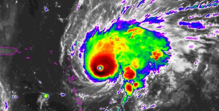
| Above: Infrared satellite image of Hurricane Irma as of 12:27 am EDT Saturday, September 9, 2017. Image credit: NASA/MSFC Earth Science Branch. |
Still en route to a potentially catastrophic hit on Florida, Hurricane Irma sideswiped its way onto the Camaguey Archipelago along the north coast of Cuba on Friday night. Hurricane Hunters found that Irma had re-intensified to Category 5 strength even as its eyewall moved onto the sparsely populated islands, with flight-level winds of 183 mph. (Update: Irma's continued track along the Cuba coast weakened it overnight. As of 8:00 am EDT Saturday, Irma was a low-end Cat 4 hurricane with top winds of 130 mph.)
As of 11 pm EDT Friday, Irma was located about 120 miles east-southeast of Caibarien, Cuba, with top sustained winds of 160 mph and a central pressure of 924 millibars. Torrential rains were falling across parts of central and eastern Cuba, and the storm’s outermost rainbands began moving into far South Florida late Friday night.
The northern coast of #Cuba is now taking the brunt of #Irma's eyewall. pic.twitter.com/7V5Ha0v8qb
— Levi Cowan (@TropicalTidbits) September 9, 2017
Irma was tracking just north of due west on Friday night, but it appeared to be angling more west-northwest over time. This will keep Irma’s southwest eyewall over the islands and low-lying coastal plain through midday Saturday. Irma could drop to Category 4 strength during this time, although the bulk of Irma’s robust circulation will remain over water. The 00Z GFS agreed very closely with earlier guidance that Irma’s eye will hug the north Cuba coast until Saturday afternoon, then move onto the very warm waters of the Florida Straits.
With no weather features acting as a brake on Irma’s strength through Saturday night, it is prudent to assume that Irma will approach the Florida Keys as a Category 4—perhaps even a Category 5, as predicted by the National Hurricane Center late Friday night.
Hurricane Warnings were extended up both sides of the Florida peninsula late Friday, running from the Anclote River on the west to the Volusia/Brevard County line on the east. Hurricane Watches extended from Indian Pass to Fernandina Beach—a remarkable swath that included the entire coastline of the peninsula, plus about half of the Florida Panhandle coast, including Tallahassee and Apalachicola. Based on the 00Z GFS, it appears that Irma is still most likely to be a “peninsula runner,” moving on a SSE-to-NNW track near or just inland from the west coast. Irma represents an extreme danger to much of Southern Florida, as well as portions of northern Cuba and the southernmost Bahama Islands. If you live by the coast in an area that has been ordered to evacuate due to storm surge, get out now if you can still safely do so.
Key points
Irma will be tracking north-northwest along the length of the Florida peninsula. The most recent consensus of models is that this track will run inland along the west side of the Florida peninsula from south to north, although it could end up just offshore or farther inland. There are no recent precedents for Irma’s expected north-northwest track. The best analog would be Hurricane Cleo (1964), which took a similar NNW track along the eastern peninsula. Cleo was a much weaker storm than Irma, though: it weakened from a Cat 2 at landfall near Miami to a tropical storm near Savannah, GA. Hurricane Donna (1960) traveled over land from the SW to NE sides of the peninsula: Donna was a Cat 4 near Marathon and still a Cat 1 when it moved back offshore at Daytona Beach.
The highest risk for the worst winds is in South Florida. The very strongest winds will be in the eyewall, especially just east of Irma’s center as it moves north. If Irma comes inland across far southwest Florida, it may pass directly over Naples, and the eyewall will extend across the Everglades and perhaps as far as portions of Miami. Winds will be stronger at the upper stories of high-rise buildings, up to a full category above surface-level speeds. We can expect many windows in the Miami area that are not up to current code to be blown out. Only a slight eastward departure in track could bring the core of the most dangerous winds to the Miami area. Hurricane-force winds are possible, and damaging tropical-storm-force winds are very likely, well up and down the west and east coasts of Florida, as well as inland, including the Orlando area.
If you live outside the evacuation zone in far South Florida, take shelter in as sturdy a building as possible. Mobile homes are not safe shelter in the winds of a major hurricane.
Tropical storm force winds (sustained winds of 39 mph or more) may extend well inland across parts of southern Georgia. These could be strong enough to topple trees and knock out power. Across parts of Florida, such winds may extend over the better part of a day.
Per @NWSTampaBay: Hourly forecast analysis shows sustained TS-force winds in Tampa from 3pm Sunday to 10am Monday. Peak: 92 mph at 2AM Mon. pic.twitter.com/UW9pzhjF8J
— Steve Bowen (@SteveBowenWx) September 9, 2017
Dangerous storm surge is expected across far South Florida, including the Naples and Miami areas, the Florida Keys, and the Everglades. There is the potential for water heights of 9 or more feet above ground level in some coastal areas from Cape Coral/Fort Myers to the Everglades, as well as along parts of Biscayne Bay. The surge may be highly variable and quickly changing along and near Biscayne Bay in the Miami area. In southwest Florida, the surge may be greatest during the southwesterly onshore winds after Irma has passed just to the north.
Although NHC has not yet posted a Storm Surge Watch for the coast of northern Florida, Georgia, and southern South Carolina, the concave coastline in this area tends to concentrate storm surge, and a significant surge may occur there. This surge is likely to be less than that of Hurricane Matthew of last year, though.
Power outages will affect millions of Floridians and could last for days or weeks.
 |
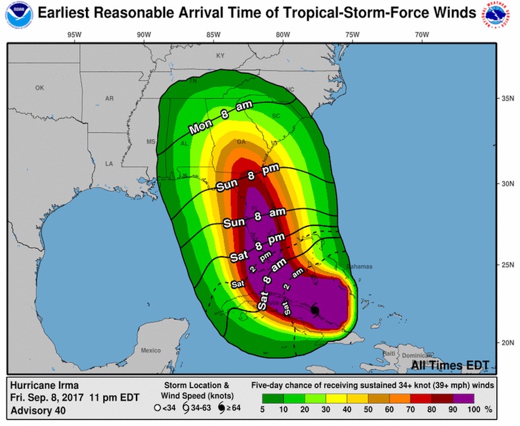
| Figure 1. Winds of tropical storm force (sustained 39-mph winds) will spread northward across Florida from Saturday morning to Sunday afternoon. Virtually the entire peninsula has a better-than-90% chance of getting tropical-storm-force winds. Image credit: NHC. |
 |
| Figure 2. Enhanced infrared satellite image of Hurricane Jose as of 12:15 am EDT Saturday, September 9, 2017. Image credit: NOAA/NESDIS. |
Jose approaches Category 5 strength
A remarkable burst of intensification for Hurricane Jose continued Friday night. Data from a Hurricane Hunter mission found that Jose’s top winds had risen to 155 mph, just shy of Cat 5 strength. Jose was located about 265 miles east-southeast of the northern Leeward Islands at 11 pm EDT Friday, continuing on a steady west-northwest course at 14 mph. Friday morning’s suite of ensemble model guidance was nearly unanimous in putting Jose on a more northwesterly course that would take the storm just northeast of the hard-hit islands of Barbuda and St. Martin/St. Maarten. The good news is that Jose is a much smaller storm than Irma, with hurricane-force winds extending only about 25 miles to the southwest of its center. If Jose adheres to the 11 pm EDT Friday forecast from NHC, it will pass no closer than about 30-40 miles northeast of Barbuda. This would give the island gale-force winds and possibly heavy squalls, but NHC guidance yielded only a 19% chance of hurricane-force winds at Barbuda and a 13% chance at St. Thomas.
Several factors will likely pull down Jose’s peak winds this weekend, including cooler waters left behind in the wake of Irma and an increase of wind shear to around 20 knots by Sunday, but Jose should manage to remain a hurricane for at least the next five days. Models agree that Jose will stall out in the open Atlantic well south of Bermuda by the middle of next week. Beyond that point, Jose's future is highly uncertain, though an eventual recurvature well out to sea appears to be most likely.
Katia sweeps onto Mexico’s Veracruz coast
Small but potent Hurricane Katia made landfall around 11 pm EDT Friday on the coast of Mexico’s Veracruz state about 120 miles south-southeast of Tampico. Katia’s top winds several hours prior to landfall were 105 mph (Category 2), but by 11 pm, Katia’s winds were already down to 75 mph, and the hurricane was predicted to be a tropical storm before dawn and no longer a tropical cyclone by late Saturday. Torrential rains of up to 25” could occur near Katia as the storm and its remnants push into the mountains just inland from the Bay of Campeche coast.
Dr. Jeff Masters and I will be back with our next Irma update on Saturday.


