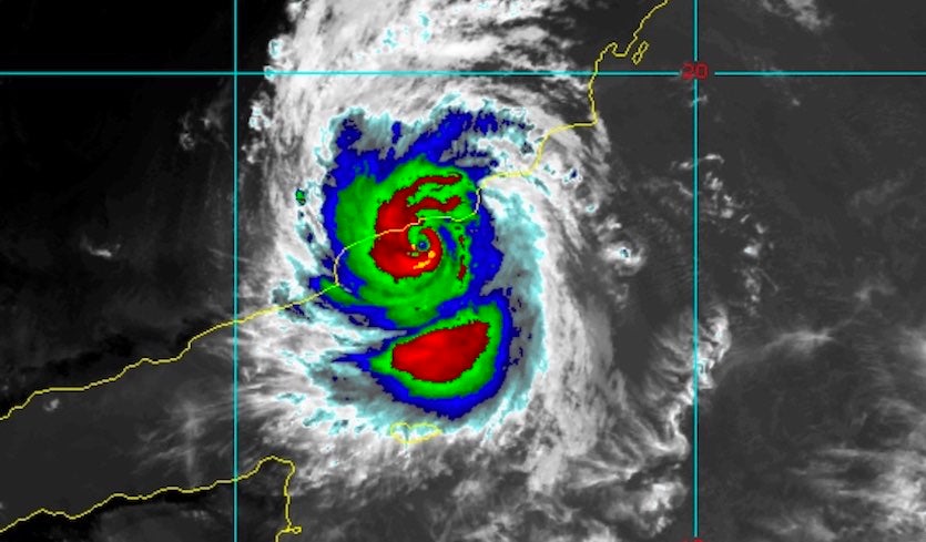
| Above: METEOSAT infrared satellite image of Cyclone Mekunu as it approached the coast of southern Oman at 1330Z (5:30 pm local time) Friday, May 25, 2018. Image credit: RAMMB-CSU. |
On Friday afternoon local time, Cyclone Mekunu was nearing landfall on the coast of southern Oman near or just west of the city of Salalah (metro population 340,000). As of 12Z (4 pm local time), the Joint Typhoon Warning Center placed the center of Mekunu about 45 miles south-southeast of Salalah, moving north-northwest at about 10 mph. According to JTWC, Mekunu’s top 1-minute sustained winds had increased to 100 knots (115 mph) at 12Z, making it the equivalent of a Category 3 hurricane. If Mekunu comes ashore at that strength, or even at Category 2 strength, it will be the most powerful cyclone at landfall for this part of the Arabian Peninsula in at least the past 60 years.
Satellite loops show that Mekunu carried out an impressive burst of intensification as it neared the Oman coastline, with showers and thunderstorms wrapping around a small, sharpening eye about 18 miles in diameter. Landfall was predicted by JTWC to occur around 2 pm EDT or 10 pm local time Friday, with the center expected to pass over or very near Salalah.
Recent satellite loop of Cyclone #Mekunu as it approaches landfall over southwestern #Oman. pic.twitter.com/Ypjlc4WYDZ
— Met Office Storms (@metofficestorms) May 25, 2018
Salalah facing a major hit from Mekunu
Mekunu poses an exceptionally unusual and serious threat to far southern Oman. There is no known precedent for a cyclone of this strength in the region. Waves estimated by JTWC as high as 32 feet will be slamming into the coast atop a significant storm surge. Because Mekunu is making landfall at a nearly perpendicular angle, its winds will be slamming against a wall of mountains just a few miles inland from Salalah that extend up to 4900 feet in elevation. The upslope flow will greatly enhance local rainfall totals on the seaward slopes of these mountains, and the runoff will pour down normally dry valleys known as wadis onto the coastal plain into and near Salalah, with the risk of potentially devastating flash floods on top of any surge-related flooding along the coast. Residents in valleys and low-lying areas were advised to evacuate by Oman Civil Defense, according to the Khaleej Times.
 |
| Figure 1. This archived NASA satellite image, collected in 2000 from the Shuttle Radar Topography Mission, depicts the region around Salalah. The city lies along a broad coastal plain in far southwest Oman. Less than 15 km (9 mi) north of the city are the Qara Mountains, with peaks ranging as high as 1500 m (4900 ft). Image credit: NASA, via archive.org. |
At 5:50 pm local time (9:50 am EDT), the Salalah airport recorded east-northeast winds of 47 mph, gusting to 68 mph. The airport has already received 2.91” of rain, more than half of its annual average of around 5”. Rainfall totals could reach 5-10” on the coast near Salalah, and localized amounts well above 12” can be expected at higher elevations. The impacts of Mekunu could extend to parts of far northeast Yemen, a war-torn country already experiencing great suffering.
We will have a full update on Mekunu and its impacts in a forthcoming post. Our Thursday post on Mekunu includes more detail on the geography of the landfall region and the history of tropical cyclones in the Arabian Sea. Frequent updates on Mekunu’s status and impacts can be found at weather.com.
We'll have a post on newly designated Subtropical Storm Alberto by around noon EDT Friday.


