| Above: Tropical Cyclone Mekunu as seen on Wednesday morning, May 23, 2018. At the time, Mekenu was a strong tropical storm with 70 mph winds. Image credit: NASA. |
Tropical Cyclone Mekunu is steadily intensifying in the Arabian Sea as it heads north-northwest towards Oman, and is expected to make landfall at Category 2 hurricane-strength near the Oman-Yemen border on Friday night or Saturday morning local time. At 2 am EDT Wednesday, Mekunu was a strong tropical storm with 70 mph winds, and had developed an eye, as seen on satellite imagery. The storm had a large and impressive amount of heavy thunderstorms, and appeared well-organized. Update: As of 8 am EDT Wednesday, the Joint Typhoon Warning Center upgraded Mekunu's peak 1-minute winds to 75 mph, making it the equivalent of a minimal Category 1 hurricane.
Conditions were very favorable for intensification, with sea surface temperatures (SSTs) ranging from 31 - 32°C (88 - 90°F), giving the storm an exceptional amount of heat energy to work with. Warm waters extended to great depth along the path of the storm, giving Mekunu a Tropical Cyclone Heat Potential in excess of 100 kilojoules per square centimeter—the kind of heat content often seen leading to rapid intensification. Wind shear over the system was a low to moderate 5 - 15 knots on Wednesday--also favorable for intensification. The Madden-Julian Oscillation (MJO), a pattern of increased thunderstorm activity near the Equator that moves around the globe in 30 - 60 days, and which can increase the odds of tropical cyclone formation when it is strong and located in the proper location, is currently strong and located in the Arabian Sea, a position that favors intensification of Mekunu. The atmosphere surrounding Mekunu is quite moist, but the storm will likely begin to pull in dry air from the Arabian Peninsula on Thursday as it approaches the coast, potentially disrupting the inner core of the storm.
 |
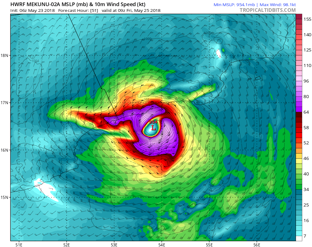
| Figure 1. Predicted wind speed (knots) for Mekunu at 9Z Friday, May 25, 2018 (1 pm local time) as predicted by the 6Z Wednesday, May 23, 2018 run of the HWRF model. This forecast has Mekunu making landfall near the Oman-Yemen border on Friday afternoon as a high-end Category 2 hurricane with 110 mph winds and a central pressure of 954 mb. Official forecasts are calling for landfall on Saturday morning. Purple colors correspond to Category 1 hurricane strength (64 knots and greater). Image credit: Levi Cowan, tropicaltidbits.com. |
With conditions expected to be very favorable for intensification through Thursday, steady and possibly rapid intensification should occur. Once Mekunu gets within six hours of landfall near the Oman-Yemen border on Friday or early Saturday, ingestion of dry air and land interaction may significantly disrupt the storm. The official forecasts from Wednesday morning from the Joint Typhoon Warning Center (JTWC) and India Meteorology Department (IMD) have Mekunu making landfall as a Category 2 storm with 100 - 105 mph winds on Saturday morning local time. The GFS and HWRF models are calling for a somewhat earlier landfall on Friday afternoon or evening local time. The official intensity forecast of Category 2 strength follows the 0Z Wednesday guidance from two of our best intensity models, the HWRF and COAMPS-TC models, which show Mekunu peaking as a Category 2 storm. It would not be a surprise, though, if Mekunu intensifies into a Category 3 storm with 115 – 125 mph winds just before landfall. Once landfall occurs, Mekenu will weaken very rapidly due to land interaction and dry air ingestion.
The ridge of high pressure steering Mekunu to the north-northwest is expected to shift westwards on Thursday, resulting in a change in the steering currents. This will force the cyclone on more of a northwesterly track a few hours before landfall. This predicted shift in steering currents is causing some spread in the location and timing of Mekunu’s landfall among the models. While both JTWC and the India Meteorological Department (IMD) were calling for a landfall in western Oman between Salalah and the Yemen border in their Wednesday morning forecasts, the shift in steering currents just before landfall could take Mekunu to a landfall farther to the west in eastern Yemen.
 |
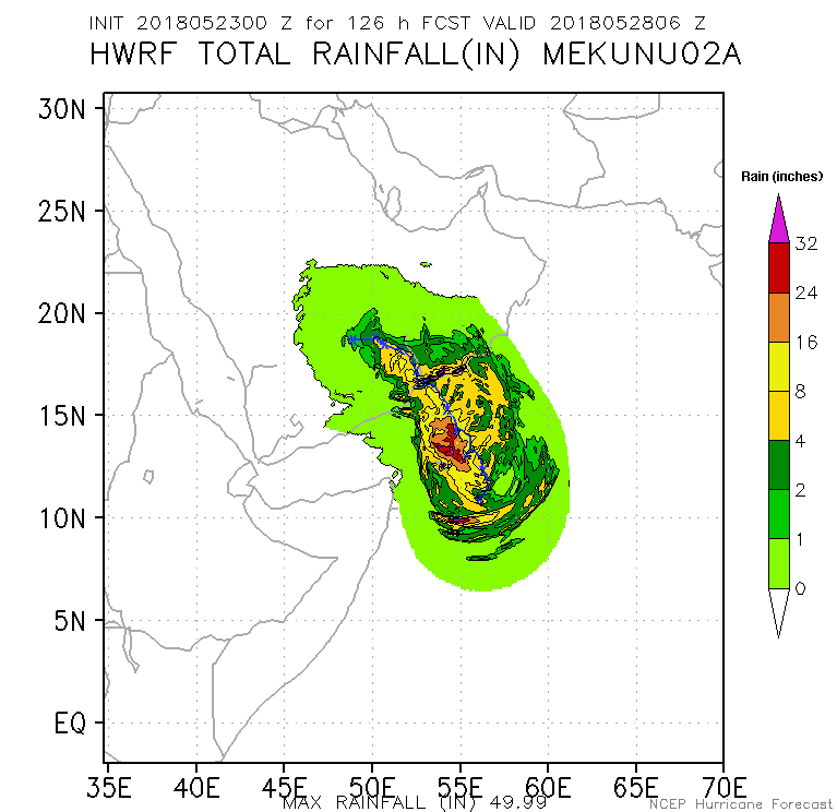
| Figure 2. Predicted rainfall along the path of Tropical Cyclone Mekunu, as predicted by the 0Z Wednesday run of the HWRF model. Image credit: NOAA/NCEP. |
A dangerous flash flood threat
Salalah, Oman (population 340,000) is a major port city and tourist destination, and receives just five inches of rain per year on average. The region could easily see double that amount of rain from Mekunu, leading to significant flash flooding. The 0Z Wednesday run of the HWRF model (Figure 2) predicted a swath of 4 – 8” of rain would fall along a 150 mile-long section of the coast near the Oman-Yemen border, with rains in excess of 8” falling inland over mountainous terrain. Wind damage and storm surge are also significant threats, but it is Mekunu’s flooding rains that pose the main risk.
We’ll have an update on Atlantic Invest 90L before 2 pm EDT.http://www.usno.navy.mil/NOOC/nmfc-ph/RSS/jtwc/warnings/io0218.gif


