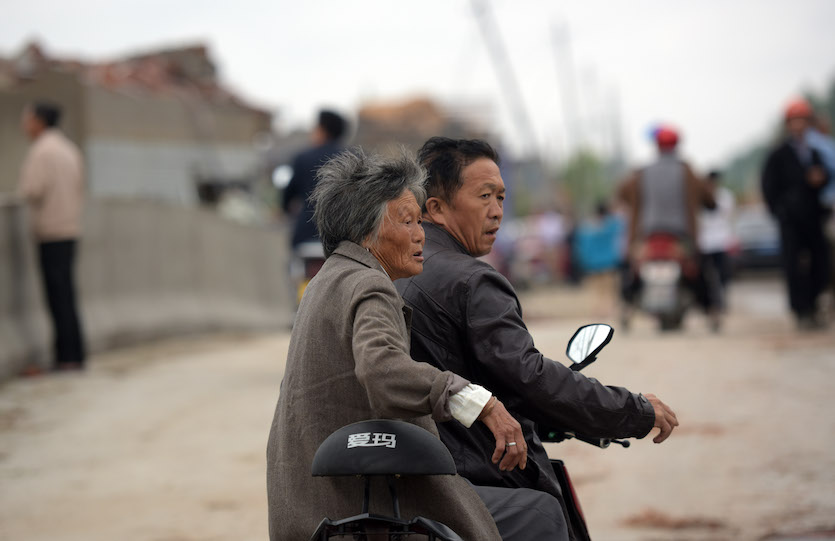
| Above: A villager in a collapsed house in Danping Village of Chenliang Township in Funing, Yancheng, east China's Jiangsu Province, on June 25, 2016. A total of 98 people were killed in several towns in Jiangsu on Thursday, and 846 people sustained injuries, 200 of whom were seriously wounded. Image credit: Photo by Wang He/Getty Images. |
The deadliest tornado to strike China in 40 years has now become the first in the nation’s history to be confirmed as an EF4 on the Enhanced Fujita Damage Scale. A total of 98 people were killed and 846 injured when a massive, long-lived tornado ground across portions of Funing County in China’s east-central Jiangsu Province, about 150 miles northwest of Shanghai, on June 23, 2016. The twister destroyed some 3200 homes and several schools and warehouses.
A forthcoming paper now in early online release at Weather and Forecasting documents the Funing tornado in detail. The study includes experts from nine institutions in China and the United States, led by Zhiyong Meng (Peking University)
Uncommon but dangerous
Tornadoes are far less frequent in China than in the U.S. Great Plains, Midwest, or Southeast—only about 60 are reported in a typical year, compared to more than 1000 in the United States—but they can be violent when they do form. The country’s massive population of more than 1.3 billion raises the stakes for public safety, especially since tornadoes are uncommon enough to make awareness a challenge.
At least 10 tornadoes in China are known to have killed more than 50 people in the last 70 years (see below). Many of China's worst tornadoes occur in the east-central part of the nation, where warm, moist air surges northward with the East Asian monsoon each spring and summer. An F4 twister in Jiangsu Province that took 74 lives in 1966 is the only tornado since 1950 that’s known to be roughly comparable in strength to the EF4 Funing tornado of 2016. However, damage surveys were much less comprehensive in the 1960s than they are now, which adds a dose of uncertainty. The F-scale ratings below are considered to be low-end estimates.
China's Ten Deadliest Tornadoes since 1950
Rank Date Location and province Fatalities Intensity
1 April 22, 1958 Hanchuan, Hubei 133 >=F3
2 April 16, 1977 Huanggang, Hubei 103 >=F3
3 June 23, 2016 Funing, Yancheng, Jiangsu 98 EF4
4 Aug. 29, 1969 Baxian, Tianjin >94 >=F3
5 April 14, 1978 Xianyang, Shanxi 84 ---
6 July 31, 1964 Xiaogan, Hubei 82 ---
7 April 27, 1983 Xiangyin, Hunan 81 ---
8 March 3, 1966 Yancheng, Jiangsu 74 >=F4
9 July 5, 1958 Zaozhuang, Shandong 63 ---
10 April 17, 1979 Changde, Hunan 59 ---
 |
| Figure 1. The ten deadliest tornadoes on record for China since 1951. Numbers on map correspond to the table above. Data from Meng et al., “The Deadliest Tornado (EF4) in the Past 40 Years in China,” Weather and Forecasting 2018 (in press). Background: mapswire.com. |
A stormy setup
The supercell that gave birth to the Funing tornado developed near a broad frontal zone on the south side of a cold upper low across northeast China, which helped provide upper-level wind shear. Intense storms are common in summer near the Mei-yu (or baiu) front, which typically extends from eastern China across Taiwan into the Pacific south of Japan. The Funing storm developed on the southwest end of a linear mesoscale convective system (MCS).
The surface air mass flowing into the Funing storm was very sultry, with an average temperature near the storm of 28.6°C (83.5°F) and a dewpoint of 27.1°C (80.8°F) corresponding to a surface relative humidity of 92%. Any storm forming in this environment would have a very low cloud base—a feature known to enhance tornado development, as it puts the fast-rising air just above the cloud base into alignment with low-level storm rotation.
A balloon-borne radiosonde was launched at 2 pm local time only about 40 miles northeast of where the tornado would form about 10 minutes later. Based on the radiosonde sounding as modified by the near-storm surface data, there was strong instability leading up to the Funing tornado, with a convective available potential energy (CAPE) of around 3290 J/kg. Vertical wind shear from the surface to a height of 6 km (about 20,000 feet) was greater than 23 m/s (51 mph), and storm-relative helicity up to 1 km was around 139 m2/s2. These preconditions check many of the boxes monitored by U.S. severe storm forecasters for a chance of significant tornadoes.
 |
| Figure 2. Reflectivity images from the Yancheng radar, located southeast of the Funing storm, at 2:14 pm local time (left) and 3:05 pm (right) on June 23, 2016. The tornado formed around 2:10 and dissipated around 3:00. A classic “hook echo” is evident, especially at the outset of the tornado (left). The central path of the tornado, surrounded by the outline of its damage path (defined as the edge of EF0 damage), can be seen in both figures. A second, weaker tornado (“SY Tor.”) developed after the Funing twister. Image credit: Meng et al., “The Deadliest Tornado (EF4) in the Past 40 Years in China,” Weather and Forecasting 2018 (in press), courtesy American Meteorological Society. |
The Funing tornado passed about 30 miles northwest of a radar similar to the National Weather Service WSR-88D Doppler radar units. The first tornado vortex signature appeared on radar about 30 minutes before the tornado formed. The signature eventually extended from the surface all the way to around 12 km (40,000 feet).
As the tornado scoured the landscaped, the winds varied from one side of the vortex signature to the other (“gate to gate”) by a maximum of 84.5 m/s (189 mph)—close to the typical peak value observed in EF4/EF5 tornadoes over the United States.
 |
| Figure 3. Residents walk in the rubble of destroyed houses on June 24, 2016, after a tornado hit the Funing region in China's Jiangsu Province the day before. Emergency personnel in China mounted rescue efforts amid scenes of carnage, with almost 100 people killed and more than 800 injured. Image credit: Johannes Eisele/AFP/Getty Images. |
A massive tornado
In the wake of the Funing tornado, four days of damage surveys were conducted by experts from Peking University, Foshan Tornado Research Center, the China Meteorological Administration, Jiansu Meteorological Bureau, and Nanjing University. Much like U.S. storm surveyors, they documented a variety of damage indicators that can be used to rate a storm on the Enhanced Fujita Scale, based on such factors as the quality of building construction and the amount of damage observed.
The researchers found the Funing tornado to be exceptionally large. Its damage swath was deemed to have a peak width of 4.1 km (2.5 miles), which is just shy of the widest tornado documented in the U.S.—the deadly EF5 near El Reno, Oklahoma, on May 31, 2013, which maxed out at 4.2 km (2.6 mi). A tornado this large and strong can produce damaging winds well beyond the immediate tornadic circulation. The Chinese team used two weather stations located near the damage swath to help infer the outer bounds of the tornado itself.
The weakest link: Monitoring and warning
Although China is vulnerable to deadly twisters, the nation does not have an explicit watch or warning system for tornadoes. Instead, forecasters may opt to mention the possibility of a tornado in nowcast-type bulletins that discuss other storm hazards (gusty wind, hail, heavy rain, lightning).
In the case of Funing, according to the authors, “the real-time nowcast and warning services in this event were quite successful for the severe weather hazards, but understated the tornado risk.” The rough equivalent of a U.S. severe thunderstorm watch was issued at 12:57 pm local time, but there was no mention of a tornado threat at that time. Automated software soon detected a potential tornado, and forecasters made a nowcast at 2:30 pm acknowledging the potential for an F2 tornado within two hours. By this point, the Funing tornado had already been on the ground for 20 minutes. Finally, the possibility of a developing tornado was noted in a subsequent bulletin at 2:40 pm, more than halfway through the Funing twister’s 50-minute lifespan.
 |
| Figure 4. Residents view tornado damage on June 24, 2016, the day after the Funing tornado struck. Image credit: Johannes Eisele/AFP/Getty Images. |
Forecasters in China are no doubt hobbled by the infrequent nature of tornadoes, which can make it harder to quickly spot the clues of their formation. The authors recommend tweaking the thresholds of the automated tornado detection routines to improve the odds of catching an event like the Fujing tornado before it’s well under way.
There’s also a dearth of the type of citizen storm reporting that’s now routine across most of the central and eastern United States. According to the study, forecasters got no reports of the Funing tornado from the nation’s equivalent of U.S. storm spotters. The China Meteorological Administration has now embarked on a program to develop an improved tornado reporting system and is testing new methods of monitoring and warning.
 |
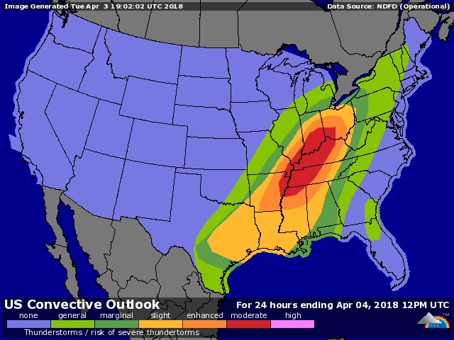
| Figure 5. WU depiction of NOAA/NWS/SPC severe weather outlook issued at 11:30 am CDT Tuesday, April 3, 2018, available on WU's Severe Weather Forecast page. |
Moderate risk for severe weather on Tuesday across mid-Mississippi and Ohio valleys
Late Tuesday morning, April 3, the NOAA/NWS Storm Prediction Center upgraded a zone of expected severe weather to “moderate,” the second highest of SPC’s five risk levels. The area of greatest threat runs from near Memphis, Tennessee, to near Cincinnati, Ohio, just ahead of a strong cold front.
Initial storms this afternoon will most likely develop as a line of discrete supercells capable of very large hail (larger than 2” in diameter) and tornadoes, some of which could be strong. The storms are expected to congeal by Tuesday evening into a powerful, fast-moving squall line, with the potential for damaging downburst winds gusting above 75 mph. See the weather.com feature for regular updates on today’s situation.


