| Above: Infrared GOES-16 satellite image of Tropical Storm Cindy as it approached the U.S. Gulf Coast at 12:52 pm EDT Tuesday, June 20, 2017. Showers and thunderstorms are concentrated on the northeast side of Cindy’s broad center, with almost none on the southwest side. GOES-16 satellite images are preliminary and non-operational. At the time of this image, Cindy was classified as Potential Tropical Cyclone 3. Image credit: College of DuPage. |
Newly christened Tropical Storm Cindy may produce extreme rainfall amounts on the central U.S. Gulf Coast. The NWS/NOAA National Hurricane Center upgraded Cindy to tropical storm status at 2:00 pm EDT after Hurricane Hunter flight data and satellite imagery confirmed that Cindy had developed a closed low-level center of circulation. At 2:00 pm, Cindy was stationary, located about 355 miles southeast of Galveston, TX. Top sustained winds were 45 mph.
Although it's been designated as a tropical storm, Cindy bears some of the hallmarks of a subtropical storm. For example, nearly all of Cindy's showers and thunderstorms were bubbling to the northeast of its low-level center in a comma-shaped pattern (see this dramatic loop of GOES-16 visible imagery).
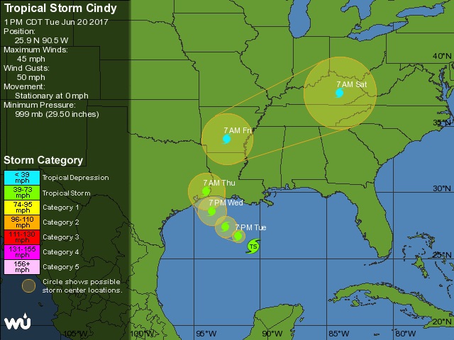
Cindy is expected to resume motion toward the northwest later on Tuesday and eventually make landfall along the upper Texas or western Louisiana coast as a tropical storm on Thursday. The main impacts will be to the right of Cindy's center, where virtually all of its significant winds and rains are located. Tropical storm warnings have been hoisted from High Island, TX, across the southeast TX and entire Louisiana coast to the mouth of the Pearl River. The warnings extend inland to include Lake Charles and Lafayette, although the New Orleans area was not included as of midday Tuesday.
 |
| Figure 1. Tracking map for Tropical Storm Cindy as of 2:00 pm EDT Tuesday, June 20, 2017. Image credit: NOAA/NWS/NHC. |
Cindy will be aiming toward a weakness in the upper-level flow associated with a trough of low pressure in the eastern U.S. It now appears that Cindy will split the difference between the tracks favored for days by the European model (TX/MX) and GFS model (MS/AL/FL). Conditions do not support major strengthening, as Cindy is experiencing moderate to strong wind shear of 20 – 30 knots and passing over waters that are near to slightly cooler than average (about 28°C or 82°F). Cindy's winds are unlikely to increase significantly before landfall.
There is a risk of severe weather, including tornadoes, near the coast east of Cindy's center, especially from southeast Louisiana into the western Florida Panhandle.
Coastal impacts from Cindy
Coastal surge impacts should be relatively minor from Cindy, due to its modest strength and asymmetric structure. According to storm-surge expert Hal Needham, the topography of the coast will be most effective in generating storm surge well east of Cindy's landfall, over far southeast Louisiana and Mississippi. Maximum storm surge is expected to be in the range of 1 to 3 feet. Flooding was already being reported at midday Tuesday in the normally flood-prone parts of Dauphin Island, Alabama. Rip currents will be very strong ahead of Cindy, and recreationalists should stay out of the water.
The big threat from Cindy: Torrential rains and flooding
Heavy rains are already pushing into the Southeast as far afield from Cindy as the Carolinas, and these may intensify in what’s known as a “predecessor rain event” (PRE). The shield of moisture ahead and rightward of the path of a tropical cyclone can generate far-flung rains a day or two ahead of landfall if the moisture happens to encounter a pre-existing frontal zone, such as the one now stretching from northern Alabama to the mid-Atlantic.
 |
| Figure 2. A swath of rainfall from Louisiana to North Carolina had developed ahead of a frontal zone in association with the circulation from Tropical Storm Cindy, as shown on WU’s WunderMap on Tuesday morning, June 20, 2017. x |
Despite its relatively weak winds and poor organization, Cindy will haul a very impressive slug of tropical moisture into the eastern United States. Precipitable water (the amount of moisture in a column above the surface) is predicted to reach or exceed 2.5” in the New Orleans area by tonight, which would be among the three highest values ever recorded there in June. PW values of more than 2” will overspread most of the Deep South by Wednesday, helping to fuel very heavy rains.
Models have been insistent on producing a focused pocket of 10” – 20” rains close to the coast well east of Cindy, likely somewhere between southeast Louisiana and the western Florida Panhandle. Parts of the central Gulf Coast have already had an unusually wet June, and significant local impacts could be expected if these rains materialize. Much of the inland South could also see 5” or more of rain from Cindy (see Figure 3). A new front will push into the Ohio Valley toward the weekend as the remnants of Cindy make their way up the Mississippi Valley and eastward. Together, these could produce an additional swath of very heavy rain across Kentucky and/or Tennessee late this week.
 |
| Figure 3. Rainfall totals predicted by the NOAA/NWS Weather Prediction Center for the 7-day period from 8:00 am EDT Tuesday, June 20, 2017, through June 27. Image credit: NOAA/NWS/WPC. |
 |
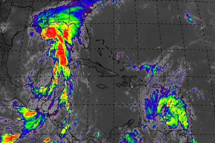
| Figure 4. Enhanced infrared satellite image of Tropical Storm Cindy (upper left) and Tropical Storm Bret (lower right) as of 1615Z (12:15 pm EDT) Tuesday, June 20, 2017. At the time of this image, Cindy was still classified as a potential tropical cyclone by NHC. Image credit: NASA MSFC Earth Science Office. |
Bret enters the southeast Caribbean
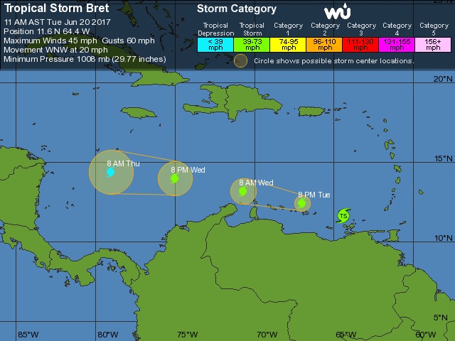
Tropical Storm Bret nicked the southwest end of Trinidad and the northeast coast of Venezuela early Tuesday as the storm moved at a brisk 21 mph into the southeast Caribbean. Bret has remained a minimal tropical storm since it was christened on Monday afternoon, with top sustained winds of only 40 mph. As of 11:00 am EDT, Bret was located about 315 miles east of Curacao, which will experience Bret’s weaker south side. A wind gust to 41 mph was reported at midnight Monday night at Piarco International Airport on the north side of Trinidad, with 2.63” of rain from Sunday through midday Monday. Farther from Bret’s center, sustained winds reached 48 mph with gusts to 52 mph at Point Salines International Airport on Grenada early Tuesday.
Southerly wind shear—a common feature of the eastern Caribbean during June—will take an increasing toll on Bret as the storm continues moving toward the west-northwest. As its low-level and upper-level centers become increasingly decoupled by the wind shear, Bret is expected to dissipate by Thursday before it reaches the western end of the Caribbean. Update: Bret was declared a tropical wave at 5:00 pm EDT Tuesday, bringing a rapid end to its life as a tropical cyclone.
 http://www.nhc.noaa.gov/text/refresh/MIATCPAT2+shtml/202031.shtml? http://www.nhc.noaa.gov/text/refresh/MIATCPAT2+shtml/202031.shtml? |
| Figure 5. WU tracking map for Tropical Storm Bret as of 11:00 am EDT Tuesday, June 20, 2017. |
Twin tropical storms in June? Unusual, but not unheard of
Today marks the first time in recent hurricane history that two named storms have been prowling the Atlantic at the same time during the month of June. According to expert Phil Klotzbach (Colorado State University), the last time this occurred was on June 23, 1968, when we had Tropical Storm Candy in the western Gulf while Hurricane Brenda was affecting Florida. On June 18, 1959, Tropical Depression Beulah was weakening in the western Gulf while a system classified posthumously as Hurricane Three was an intensifying tropical storm in the northwest Atlantic. And more than a century ago, Hurricane Two and Tropical Storm Three overlapped for several days near the end of June 1909. Update: Since Bret was declared a tropical wave by NHC at 5:00 pm EDT Tuesday, we had only a six-hour period on Tuesday with simultaneous named storms in the Atlantic.


