| Above: Tropical Storm Franklin as seen at 12:07 pm EDT August 9, 2017. At the time. Franklin had top winds of 70 mph. Image credit: NASA/GSFC. |
Tropical Storm Franklin is steadily intensifying over the hurricane-friendly waters of Mexico’s Bay of Campeche, and is expected to be a Category 1 hurricane with top winds near 85 mph when it makes landfall in the Veracruz state of Mexico, about 70 miles north-northwest of the city of Veracruz, late Wednesday night. Satellite images on Wednesday afternoon showed that Franklin was an average-sized tropical storm, with plenty of heavy thunderstorms that filled most of Mexico’s Bay of Campeche. A large rain band was already bringing torrential rains to much of the coast in the warned area. Conditions were favorable for intensification, with sea surface temperatures (SSTs) near 30°C (86°F), plenty of moisture (a mid-level relative humidity near 70%), and moderate wind shear of 15 knots. An Air Force hurricane hunter aircraft penetrated into Franklin's eye at 12:42 pm EDT Wednesday, and found the central pressure was 985 mb--the same as the pressure from NHC's 11 am EDT Wednesday advisory. Radar from a NOAA hurricane hunter aircraft earlier this morning showed that Franklin had not yet built a well-defined eyewall, but the 12:42 pm EDT Wednesday eye report from the Air Force plane reported that Franklin had indeed built a full eyewall, with an elliptical-shaped eye 40 miles long by 20 miles wide.
 |
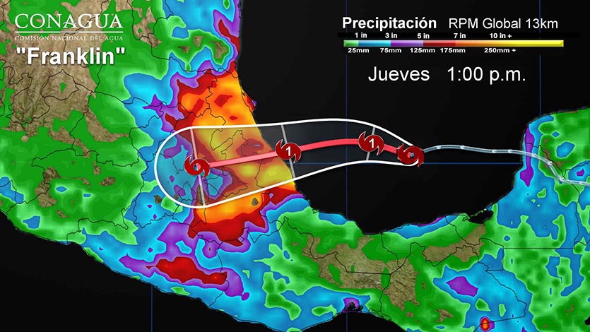
| Figure 1. Rainfall forecast for Franklin from the RPM model for the period ending 1 pm CDT Thursday (Jueves), August 10, 2017. Image credit: CONAGUA. |
Forecast for Franklin
There’s not much time for intensification of Franklin beyond Category 1 status, and the storm is primarily a heavy rainfall threat for Mexico, with widespread rain amounts of 4 – 8” expected. Franklin should have a lower impact than the last hurricane to hit the state of Veracruz, Hurricane Karl, whose eye crossed the coast about 10 miles north of Veracruz on September 17, 2010. Karl was the only major hurricane ever recorded in the Bay of Campeche (south of 21° N latitude), and peaked as a Category 3 storm with 125 mph winds, about 5 hours before landfall. Karl brought a large area of 10 – 15” rainfall amounts to the northwestern half of the state of Veracruz. AIR Worldwide estimated total damage costs in Mexico at $206 million, and Karl killed 22 people. Karl did not get its name retired.
Invest 99L not a threat to land areas
An area of low pressure (99L) located about 400 miles east of the northern Lesser Antilles Islands at 8 am EDT Wednesday was headed west-northwest to northwest at about 10 mph. Satellite images on Wednesday afternoon showed that 99L had only a sparse amount of heavy thunderstorm activity, but a modest degree of spin. The atmosphere surrounding the disturbance was quite dry, with a mid-level relative humidity around 45%.
The 12Z Wednesday run of the SHIPS model predicted that wind shear would drop to the low range, less than 10 knots, on Friday and Saturday, when 99L was expected to be a few hundred miles north of the Lesser Antilles Islands. However, the atmosphere was predicted be very dry at that time, potentially limiting development--unless 99L can carve out a protective “pouch” of moisture to stave off the dryness.
By Sunday, 99L should find a moister atmosphere with mid-level relative humidity around 60%, though wind shear is predicted to rise to a moderately high 15 – 20 knots by then. Sea surface temperatures will be plenty warm enough for development, around 29°C (84°F)--about 1°C above average for this time of year. The 0Z Wednesday European model ensemble forecast had 46% of its members bringing 99L between North Carolina and Bermuda as a tropical storm early next week. However, our other two reliable models for predicting tropical cyclone genesis, the GFS and UKMET models, did not show development of 99L in their 0Z Wednesday runs. The 12Z Wednesday run of the GFS also showed no development, though the 12Z Wednesday run of the UKMET did show some weak development early next week.
If it does manage to develop, 99L will be steered by a large and strong Atlantic ridge extending west toward the mid-Atlantic coast. The predicted shape of the ridge, and the projected approach of a strong upper-level trough across the Northeast U.S., suggests that 99L will recurve to the north and north-northeast between North Carolina and Bermuda, sparing those locations any direct impacts. In its 8 am Wednesday tropical weather outlook, the NOAA/NWS National Hurricane Center gave 99L a near-zero chance of developing into at least a tropical depression by Friday morning, but a 40% chance by Monday morning.

NOAA issues its final Atlantic hurricane season forecast
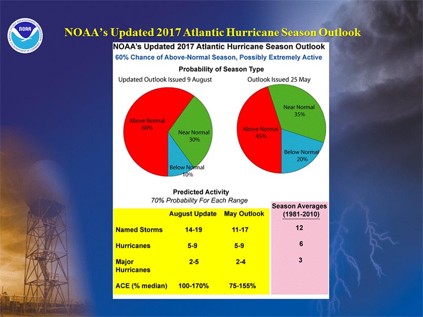
NOAA has issued their final Atlantic hurricane season forecast on Wednesday morning, calling for 14 - 19 named storms, 5 - 9 hurricanes, 2 - 5 major hurricanes, and an Accumulated Cyclone Energy (ACE) 100% - 170% of the median (including the ACE from the six named storms to date.) If we take the midpoint of these numbers, the forecast is for 16.5 named storms, 7 hurricanes, and 3.5 major hurricanes. An average Atlantic hurricane season produces 12 named storms, of which six become hurricanes, including three major hurricanes. The midpoint numbers in the latest NOAA outlook compare to 14 named storms, 7 hurricanes, and 3 major hurricanes from the original 2017 outlook, issued by NOAA on May 25.
The forecasters said the 2017 season could be the most active since 2010, with a 60 percent chance of an above-normal season (compared to the May prediction of 45 percent chance.)
Bob Henson contributed to this post.


