| Above: A funnel cloud moves near Troy, Ala., on Thursday, April 27, 2017. Storms moving through the Deep South left damage in southeastern Alabama on the anniversary of the deadly Super Outbreak of 2011, which killed more than 200 people across Alabama and nearly 100 more in five other Southern states. The NOAA/NWS Storm Prediction Center received numerous damage reports from the Troy area, and a radar debris signature was evident, but no tornado had yet been confirmed as of Friday morning. Four injuries were reported with the storms across Alabama and Georgia. Image credit: Adam Pendergast via AP. |
A complex setup for potentially tornadic storms late Friday will usher in a well-predicted multiday round of severe weather, including extreme rainfall, during the last three days of April.
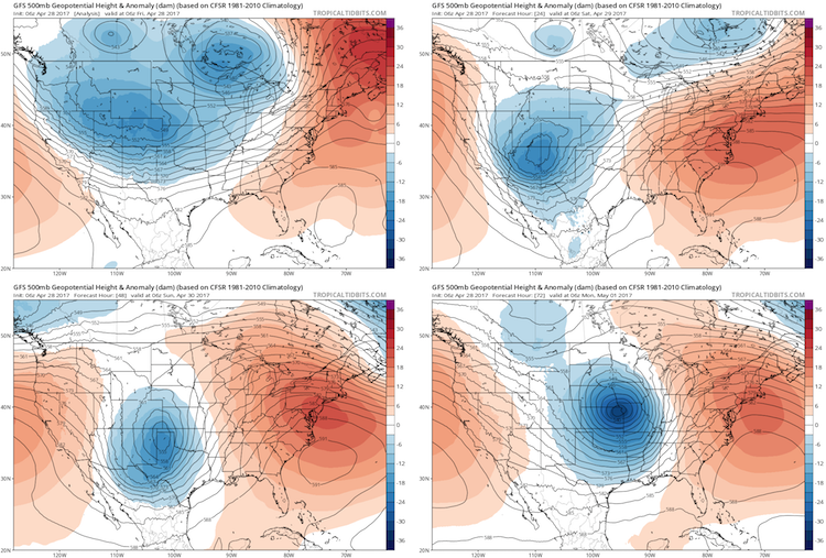
The main trigger for the upcoming storms is a huge upper-level trough that engulfed much of the United States early Friday (see Figure 1). This trough will sharpen and consolidate into a more compact upper low across the southwest U.S. by Saturday, then swing northeast into the Midwest by Monday. It’s a somewhat unusual sequence of events, but one that will end up producing widespread showers and thunderstorms (convection) along several frontal zones undulating across the southeast half of the nation. Ahead of the upper trough, an increasingly muggy air mass will send temperatures toward record- or near-record levels for late April.
 |
| Figure 1. Variations in the height of the 500-millibar surface, roughly the midpoint of the atmosphere (shown here in decamaters, or tens of meters, relative to average for this time of year), depicted by the 06Z Friday run of the GFS model for 2:00 am EDT Friday (top left), Saturday (top right), Sunday (bottom left) and Monday (bottom right). Colors correspond to departures from average. A strong trough is evident in the blue colors (below-average heights), while strong ridging in the East (above-average heights) will help generate record- and near-record heat along the Eastern Seaboard. Image credit: tropicaltidbits.com. |
First in the queue of important surface features will be a stretched-out warm front that should extend from Texas to Ohio by late Friday. Very moist, unstable air will be sweeping northward behind this front. Two big questions are how far north the front will get by late Friday, and whether a “cap” of warm, dry air about one to two miles above the surface will inhibit thunderstorms along and south of the warm front. At even higher levels, the atmosphere will be warming as the upper trough contracts, and this may cut back on instability.
The uncertain evolution of these factors makes the severe weather outlook for Friday afternoon and evening highly conditional—meaning that surface-based thunderstorms may not develop at all in some areas, but where they do, they could include a few tornado-producing supercells.
 |
| Figure 2. The NOAA/NWS Storm Prediction Center has large parts of the U.S. midsection outlined with an enhanced risk of severe thunderstorms for Friday, April 28 (left) and Saturday, April 29 (right) in outlooks issued on Friday morning. |
Wind shear beneath the strong upper trough will be quite supportive of rotating storms, especially where the warm front and a developing surface low in far western Texas manage to pull surface winds into a southeast direction beneath southwesterly upper-level winds. Two of the areas most at risk of storms becoming tornadic are the lower Ohio Valley of IL/IN/KY/TN and the Red River Valley of TX/OK. Any tornado threat may extend after dark as the warm front pushes north, with dew points eventually rising into the 65°F – 70°F range. By later in the evening, a broad swath of intense storms with heavy rain and possibly large hail is expected north of the warm front. These should mostly be elevated storms, meaning that the instability driving them will not extend all the way to ground level. Elevated storms are much less likely than surface-based storms to produce tornadoes.
Widespread flooding could materialize over the next few days
On Saturday, as the upper low sharpens and begins swinging out, the surface low will intensify across Oklahoma, pulling a fairly sharp cold front across southern OK and TX and into Arkansas and Louisiana. This front will become a second focus for potentially severe weather on Saturday, including a tornado threat. Meanwhile, storms packing heavy rain will continue to blossom along and north of the warm front, especially across Missouri and Illinois, where the flood potential will be growing over time.
 |
| Figure 3. A large swath of rainfall exceeding 5” is projected by the NOAA/NWS Weather Prediction Center for the 3-day period from 8:00 am EDT Friday, April 27, through Monday, May 1. Image credit: NOAA/NWS/WPC. |
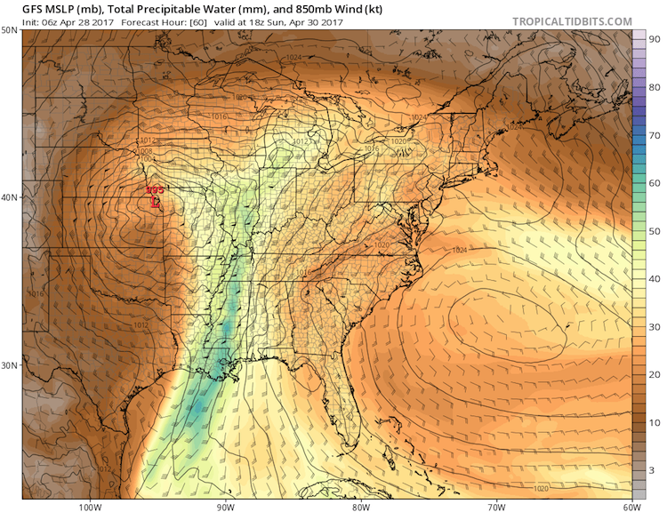
There are signs that an atmospheric river may develop all the way from Central America into the Midwest—a ribbon of moisture sometimes dubbed the Maya Express. Localized rainfall amounts could end up exceeding 10” across and east of the Ozarks over the next five days. Falling atop already-soaked ground, these amounts could pose a very real flood threat. Flash flood watches were already in place from Oklahoma to Illinois on Friday morning.
Yet another burst of severe weather is likely to begin as early as midday Sunday ahead of the eastward-plowing cold front into Mississippi, Alabama, and western Tennessee. It’s quite possible that enough storms will develop to reduce the risk of scattered tornado-packing supercells and shift the threat toward extremely heavy rain. The GFS model projects that precipitable water (the amount of moisture above a given point on the ground) could exceed 2.0” in parts of MS and AL on Sunday. In records going back to the late 1940s, such values have never been observed prior to May 1 in Birmingham, AL, and only once before May 1 in Jackson, MS.
 |
| Figure 4. A channel of very rich atmospheric moisture will be flowing from the Bay of Campeche into the U.S. South at midday Sunday, April 30. The forecast here, from the 06Z Friday run of the GFS model, is valid at 2:00 pm EDT Sunday. The amount of precipitable water in the air could exceed 50 mm (2 inches) in parts of Louisiana, Mississippi, and Alabama. Image credit: tropicaltidbits.com. |
The odds of severe weather should drop somewhat as the cold front pushes well ahead of the upper low into the Atlantic states on Monday afternoon, with lessening amounts of instability and wind shear expected ahead of it. Even so, a stray severe thunderstorm can’t be ruled out anywhere from New York to Georgia.
Still a busy year for tornadoes, but not the busiest
Thus far in 2017, the “inflation-adjusted” tornado count of 489 through April 26 is notably high, though well below the January-1-to-April-26 record of 545 in data going back to 1954. The cumulative record will jump above 600 over the next week, so it would take a massive tornado swarm—one that we’ll hopefully avoid—in order to keep pace with it.
I’ll be attending the People’s Climate March on Saturday in Washington, D.C., where temperatures will (appropriately) be at scorching levels for mid-spring, possibly even topping D.C.’s record high for the date of 91°F. Sister marches are planned across the nation and around the world on Saturday. Have a great weekend, everyone!


