| Above: Infrared GOES-16 satellite image of Tropical Storm Harvey as of 1700Z (1 pm EDT) Friday, August 18, 2017. GOES-16 data are preliminary and non-operational. Image credit: NASA/MSFC Earth Science Branch. |
Even as a minimal tropical storm (top sustained winds of 40 mph), Tropical Storm Harvey rocked parts of the Windward Islands with high surf, gusty winds, heavy rain, and flooding. As of 11 am EDT Friday, Harvey was located about 15 miles south-southwest of St. Vincent and about 50 miles south-southwest of St. Lucia. Both of those islands experienced the stronger northwest side of the storm. Harvey’s center also passed just south of Barbados, where flooding has been reported, including in the Speightstown area of northern Barbados (see embedded tweet below, via Eric Blake).
More flooding in the north of the island #Barbados @weatherchannel @bbcweather pic.twitter.com/yOwq5LZ9nl
— Barbados We Love (@BarbadosWeLove) August 18, 2017
 |
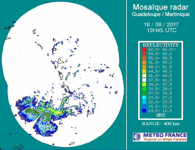
| Figure 1. Tropical Storm Harvey as seen in a mosaic of radar data from Guadelope and Martinique at 1345Z (9:45 am EDT) Friday, August 18, 2017. The most intense rains, which passed over Barbados early Friday, were about to move westward out of St. Lucia at the time of this display. Image credit: Meteo France. |
Given Harvey’s minimal strength, it’s not surprising that winds have been on the mild side. Here are some peak winds from the passage of Harvey through the Windward Islands on Friday morning:
Martinique: sustained winds of 29 mph, gusting to 44 mph, at 10 AST
St. Lucia: sustained winds of 23 mph, gusting to 43 mph, at 9:18 AST
Barbados: 24 mph sustained winds at 8 am AST
Wind shear has kept Harvey’s strongest showers and thunderstorms (convection) displaced to the west of the storm center, so most of the heaviest rains preceded the arrival of Harvey’s center. The storm is moving west at a fairly rapid clip, about 21 mph, and conditions across the Windward Islands were improving rapidly by midday Friday. Meanwhile, Harvey was continuing to expand its upper-level outflow and its shield of strong convection, an impressive sign of strength in the face of persistently strong wind shear and midlevel dry air (see below).
You can see this dry midlevel air lurking just N in a recent Guadeloupe sounding, w/ northerly flow undercutting convective outflow. pic.twitter.com/sN2JQYsbVq
— Philippe Papin (@pppapin) August 18, 2017
Outlook for Harvey
Harvey should steer clear of land areas for the next couple of days as it charges quickly westward. Computer models are in strong agreement that Harvey will traverse the entire Caribbean through the weekend. The major track question is how far north or south Harvey will be by the time it reaches land.
- If the track remains on the south side of model guidance (as suggested by the 0Z Friday UKMET run and most members of the GFS ensemble run), then Harvey will likely track along or near the Honduras coast on Monday and arrive in Belize around Tuesday.
- If Harvey stays toward the north side of guidance (as indicated by most members of the European model ensemble from 0Z Friday, and by the operational GFS run from 12Z Friday), it would remain just north of Honduras and would make landfall late Monday or Tuesday in Belize, or perhaps the Yucatan coast of Mexico.
Harvey will continue to battle strong wind shear of 15-20 knots from the northeast and north through Saturday. This will keep the storm’s convection somewhat asymmetric and inject dry air into the storm, so it is unlikely Harvey will strengthen dramatically, although some intensification is quite possible. Around Sunday, models indicate a brief window of reduced wind shear, and midlevel relative humidities should jump from around 45-50% to 70% or more. Together with very warm waters (sea surface temperatures of 29-30°C, or 84-86°F), this will give Harvey a window of potential for more rapid strengthening before it reaches Central America. None of the GFS or European ensemble members from 0Z Friday made Harvey a hurricane before landfall—nor did the 0Z and 6Z Friday runs of the HWRF, our top intensity model. Nevertheless, Harvey bears close watching for any signs of strengthening more quickly than models expect, especially on Sunday.
Harvey’s post-landfall future depends greatly on the angle of its track early next week. The more northerly European model solutions—including the 0Z Friday operational run—indicate that Harvey could get pulled northwestward through the western Gulf of Mexico, while the 0Z Friday GFS ensemble members and operational run keep Harvey moving west-northwest across the southern Bay of Campeche and into the east coast of central Mexico, similar to the track of Hurricane Franklin earlier this month. The more northward solutions would give Harvey a better chance of intensifying in the Gulf, and potentially affecting the western Gulf Coast a week or more from now; the southward solutions imply very heavy rainfall across parts of southern Mexico and Central America.
 |
| Figure 2. Invest 92L as seen by the GOES-16 satellite at 1445Z (10:45 am EDT) Friday, August 18, 2017. 92L was clearly struggling with dry air ingestion, as seen by arc-shaped low-level cumulus clouds that were racing to the northwest ahead of the storm. Image credit: NOAA/CIRA/RAMMB. NOAA’s GOES-16 satellite has not been declared operational and its data are preliminary and undergoing testing. |
92L headed towards The Bahamas
Tropical wave 92L was located about 750 miles east-northeast of northern Lesser Antilles Islands, near 17°N, 50°W, at 8 am EDT Friday. Satellite images on Friday morning showed that 92L had changed little in organization since Thursday, with a large blob of heavy thunderstorms near its center, and some modest low-level spiral banding and upper-level outflow. However, 92L was clearly struggling with dry air ingestion, as seen by arc-shaped low-level cumulus clouds that were racing to the northwest ahead of the storm. When the thunderstorms of a tropical disturbance ingest a large amount of dry air at mid-levels of the atmosphere, the resulting strong downdrafts rob the storm of moisture and hit the ocean surface with a lot of momentum, kicking up arc-shaped bands of cumulus clouds as the downdraft spreads out along the ocean surface.
Conditions were marginal for development on Friday morning, thanks to moderately high wind shear of 15 – 20 knots from a Tropical Upper Tropospheric Trough (TUTT) located to the north of 92L. This trough was also pumping dry air into 92L’s circulation. Mid-level relative humidity was 60%, which was adequate for development, and 92L had warm SSTs of 28°C (82°F) to work with. The disturbance was headed west to west-northwest at 15 - 20 mph, and will pass a few hundred miles north of the Lesser Antilles Islands on Saturday. If 92L is well enough developed, Puerto Rico, the Virgin Islands, and northern portions of Hispaniola may receive heavy rains from 92L on Sunday, and this activity will reach the southeastern Bahamas and Turks and Caicos Islands on Sunday night. A continued west-northwest motion for 92L is expected into early next week, with heavy rains from the system potentially affecting eastern Cuba and the central Bahamas on Monday and Tuesday, and potentially reaching the northwestern Bahamas and Florida by Tuesday afternoon.
There was very little model support for the development of 92L with the 0Z Friday cycle of model runs. None of the operational runs of our three reliable global models for predicting tropical cyclone genesis—the GFS, European and UKMET models—developed the system, and only about 20% of the 70 members of the 0Z Friday GFS and European model ensembles showed 92L developing into a tropical depression. None of them showed 92L developing into a tropical storm. The 12Z Friday run of the SHIPS model predicted that 92L might find a more favorable environment for development by Sunday, when the system should move far enough from the shearing winds of the TUTT to see a reduction in wind shear. If the global models are correct, though, 92L will be too disorganized to develop early next week. In its tropical weather outlook issued at 2 pm EDT Friday, the National Hurricane Center gave 92L 2-day and 5-day odds of development of 60%, down from 70% in the previous outlook. The first hurricane hunter mission into 92L is scheduled for Sunday, if necessary.
 |
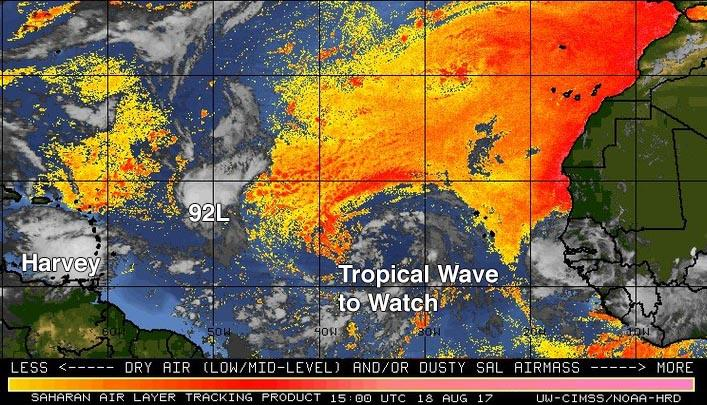
| Figure 3. The Saharan Air Layer (SAL) analysis from 11 am EDT Friday, August 18, 2017, showed that 92L was encountering dry Saharan air; a new tropical wave to watch in the Eastern Atlantic was in a moister environment. Image credit: University of Wisconsin CIMSS/NOAA Hurricane Research Division. |
Another strong tropical wave in the mid-Atlantic may develop
Another tropical wave with the potential to develop into a tropical depression was located several hundred miles west-southwest of the Cabo Verde Islands on Friday morning. This wave has the potential to develop into a tropical depression early next week as it moves west-northwest to northwest at about 15 mph. Satellite images on Friday morning showed the large wave had plenty of spin, but heavy thunderstorm activity was thin and poorly organized. Wind shear was light to moderate, 5 - 15 knots, and ocean temperatures were warm, near 27°C (81°F). The wave was in a moist environment south of the Saharan Air Layer.
The 0Z Friday operational runs of our three reliable models for predicting tropical cyclone genesis—the GFS, European and UKMET models—did not show development of this system by the middle of next week, but about 30% of the members of the 0Z Friday GFS and European model ensembles did develop it. This wave—which will presumably be labeled 93L by NHC by Saturday—is likely to pass well to the northeast of the Lesser Antilles Islands and not threaten any land areas. In its tropical weather outlook issued at 2 pm EDT Friday, the National Hurricane Center gave this future “Invest” 2-day and 5-day odds of development of 10% and 40%, respectively—the same odds as in the prior outlook.
Jeff Masters co-authored this post.


