| Above: Fishermen push a boat out of the sea in anticipation of the arrival of Tropical Storm Franklin in the port city of Veracruz in Veracruz state, Mexico on August 9, 2017. Image credit: VICTORIA RAZO/AFP/Getty Images. |
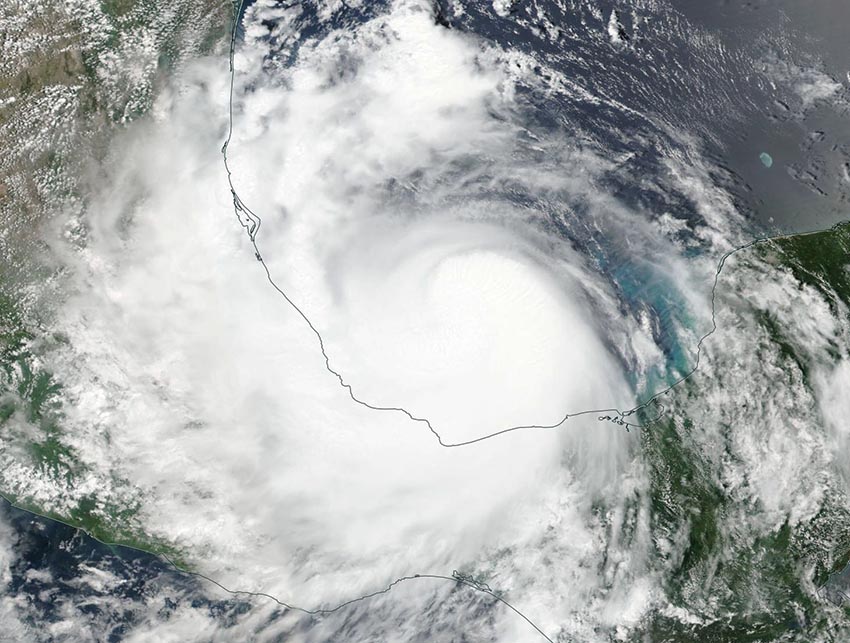
Hurricane Franklin dissipated over the rugged terrain of central Mexico east of Mexico City on Thursday morning, after making landfall at 1 am EDT Thursday, August 10, in the Veracruz state of Mexico, about 70 miles north of the city of Veracruz. Franklin became the first Atlantic hurricane of 2017 at 5 pm EDT August 9. This formation date is just one day earlier than the average August 10 formation date of the season’s first hurricane. At landfall, Franklin was at peak intensity--a Category 1 hurricane with 85 mph winds.
 |
| Figure 1. MODIS true-color satellite image of Franklin, taken at 2:54 pm EDT August 9, 2017. At the time, Franklin was a tropical storm with 70 mph sustained winds, and would be upgraded to a hurricane two hours later. Image credit: NASA. |
Impact of Franklin
Franklin should end up dumping widespread rain amounts of 4 – 8” along its track, resulting in a less severe impact than the last hurricane to hit the state of Veracruz, Hurricane Karl. Karl crossed the coast about 10 miles north of Veracruz on September 17, 2010, bringing a large area of 10 – 15” rainfall amounts to the northwestern half of the state of Veracruz. Karl was the only major hurricane ever recorded in the Bay of Campeche (south of 21° N latitude), and peaked as a Category 3 storm with 125 mph winds, about 5 hours before landfall. AIR Worldwide estimated total damage costs in Mexico at $206 million, and Karl killed 22 people. Karl did not get its name retired.
GOES-16 (prelim/non-opl) IR of Hurricane Franklin in the Bay of Campeche. Intense cloud-top cooling near center of Franklin! pic.twitter.com/hiyLw9LDPe
— NWS Wilmington OH (@NWSILN) August 10, 2017
Franklin’s remains could regenerate over the Pacific
Satellite images on Thursday morning showed that the remains of Franklin were bringing heavy rains to much of south-central Mexico, and were headed westwards at 20 mph. Franklin’s remains will emerge over the Pacific Ocean on Friday, when regeneration into a tropical depression may occur, as predicted by both the 0Z and 6Z Thursday runs of the GFS model. The European model was more ambivalent about regeneration, but did show some reorganization would occur this weekend. In their 8 am Thursday tropical weather outlook, the National Hurricane Center gave the remains of Franklin a 20% chance of redeveloping over the Pacific by Saturday morning, and a 40% chance by Tuesday morning. The storm is expected to move west-northwest, passing several hundred miles south of the southern tip of Mexico’s Baja Peninsula early next week. Since Franklin did not survive the crossing of Mexico as an identifiable tropical cyclone, the new storm would get a new Eastern Pacific name. The next named storm in the list is Jova. By early next week, any potential Tropical Storm Jova will encounter a less conducive atmosphere for development, and it is unlikely that we will see a Hurricane Jova.
As documented by The Weather Company’s Jon Erdman in his Thursday morning post, a similar scenario happened almost exactly one year ago, also resulting in an eastern Pacific "J" storm. Hurricane Earl made landfall in Belize on Aug. 4, 2016, and less than 24 hours after Earl dissipated, a tropical depression formed from the remnants of Earl. This storm went on to develop into Tropical Storm Javier. Since the mid-1960s, when satellite surveillance of the tropics became routine, the remnants of tropical cyclones crossing from one ocean basin to the other and reforming has occurred every 3 to 4 years.
 |
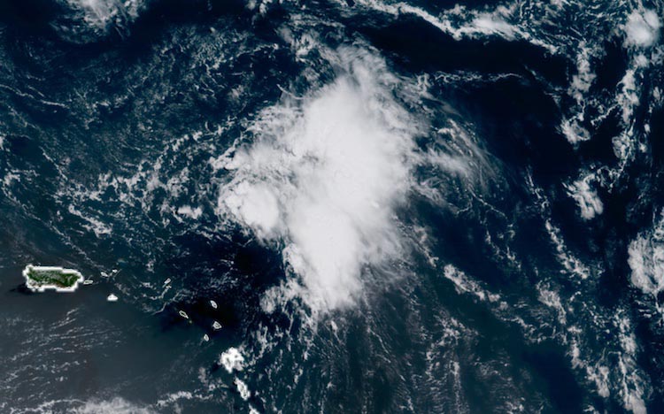
| Figure 2. Visible-wavelength GOES-16 satellite image of Invest 99L as of 1530Z (11:30 am EDT) Thursday, August 10, 2017. GOES-16 images are preliminary and non-operational. Image credit: RAMMB/CIRA/CSU. |
99L may yet develop this weekend
It’s been a fighter, but the never-say-die tropical wave known as Invest 99L continues to face long odds. The resilient system may have its last, best shot at development this weekend, though. Located several hundred miles northeast of the Virgin islands on Thursday morning, 99L maintained a small core of showers and thunderstorms (convection) through Wednesday night. The convection was not intense or very well structured, and it was mostly east of the ill-defined center of 99L, but it was expanding in area on Thursday morning. Relentless wind shear—on the order of 20-25 knots on Thursday morning—is projected in the 12Z Thursday SHIPS model output to decrease to a more moderate 10-15 knots on Friday and Saturday, before again increasing on Sunday and Monday to around 20 knots. Mid-level relative humidity around 99L is also projected to increase, to around 50-55% this weekend, and sea surface temperatures of around 29°C will be more than adequate for development. In its 8 AM Thursday tropical weather outlook, NHC gave 99L a 20% chance of development into at least a depression by Saturday and a 40% chance by Tuesday.
The European model has pulled back on its bullish outlook for 99L after most of its ensemble members a day before had developed the system into a tropical storm or hurricane. About 2/3 of the 00Z Thursday Euro ensemble members create a tropical depression out of 99L by Friday evening. However, less than 10% bring the system to tropical storm strength, and only one of the 50 members creates a long-track tropical storm that recurves off the East Coast. None of the GFS ensemble members from 00Z Thursday develops 99L at all, and the same is true in the 00Z Thursday operational runs from our three top global models for tropical cyclone development: the Euro, GFS, and UKMET.
Elsewhere in the tropics
A new wave coming off Africa early next week will bear watching as we approach the peak of the Cape Verde season, when the Main Development Region (MDR) between Africa and the Lesser Antilles is at its most active. About 30% of Euro and 20% of GFS ensemble members bring this wave to at least tropical depression strength next week, as it heads west-northwest across the MDR on a track that could end up similar to 99L’s.
The Madden-Julian Oscillation should be in a mode that favors development in the Atlantic during mid- to late August, based on the latest NOAA forecasts of rising and sinking air at upper levels.
In the Eastern Pacific, there is the chance that the remnants of Franklin will redevelop (as discussed above), and another tropical low is expected to take shape early next week further to the south. NHC gave that system a 40% chance of development through Tuesday in its Thursday morning outlook.
 |
| Figure 3. The warning, “Typhoon is coming, be careful” greets commuters on a street in Kumano, Japan, on August 7, 2017, as they prepare for the arrival of Typhoon Noru. Image credit: STR/AFP/Getty Images. |
Noru was the NW Pacific’s longest-lived typhoon in 45 years
The Western Pacific is quiet in the wake of former Category 5 Typhoon Noru, which bit the dust on Tuesday after nearly 19 days as a tropical cyclone and 14.25 days as a typhoon. Noru was the second-longest-lived typhoon on record for the Northwest Pacific in data going back to 1950. According to Phil Klotzbach (Colorado State University), Noru was topped only by 1972’s Rita, which spent 18.25 days as a typhoon during three periods from July 8 to 26. Two deaths were reported in far southern Japan as a result of Noru, according to weather.com, and power was knocked out to more than 15,000 people.
Bob Henson co-wrote this post.


