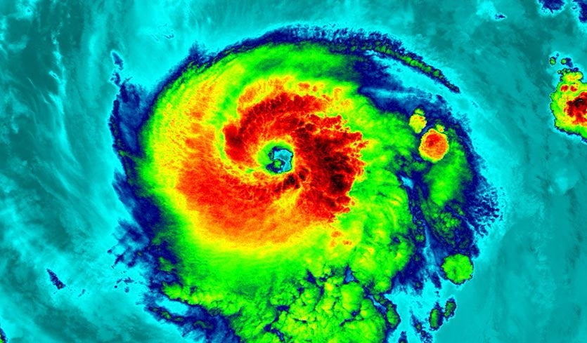
| Above: Infrared VIIRS image of Hurricane Irma at 11:47 pm EDT August 31, 2017. At the time, Irma was a Category 3 storm with 115 mph winds. Image credit: UW-Madison CIMSS. |
Hurricane Irma rapidly intensified into a Category 3 hurricane with 115 mph winds at 5 pm EDT Thursday, becoming the earliest storm on record to become a major hurricane east of 35°W. Irma is the second major hurricane of this active Atlantic hurricane season, along with Hurricane Harvey, and it has arrived more than a month before the usual October 3 date for the season's second major hurricane. Irma could potentially impact the islands of the Caribbean next week, and the mainland U.S. or Canada the following week, but uncertainties in its track at such long ranges are quite high.
Both Harvey and Irma were rapid intensifiers, bursting from tropical-storm to major-hurricane strength in less than 36 hours. Irma pulled off this feat in just 12 hours, one of the fastest such leaps on record. Very low wind shear at or below 5 knots allowed Irma to develop a large, robust structure remarkably quickly. Overnight, Irma leveled off in intensity, as it began moving over somewhat cooler sea-surface temperatures, and began an eyewall replacement cycle (ERC). As of 11 am EDT Friday, Irma had weakened to a top-end Category 2 hurricane with sustained winds of 110 mph.
 |
| Figure 1. Tracks of all Atlantic hurricanes to reach Category 3 status east of 35°W during the period of good satellite data, 1970 - 2017. Irma’s position is marked with a red hurricane symbol. Only four other hurricanes have reached Category 3 status so far east since reliable satellite records began in the early 1970s: 29.7°W: Frances (Sep. 9, 1980) 31.4°W: Julia (Sep. 15, 2010) 32.0°W: Fred (Sep. 9, 2009) 34.8°W: Irma (Aug. 31, 2017) 35.0°W: Isaac (Sep. 24, 2000) |
 |
| Figure 2. MODIS visible satellite image of Irma on Friday morning, September 1, 2017, from NASA’s Terra satellite. The eye was not as distinct as on Thursday. Image credit: NASA. |
Short-range outlook for Irma
The easiest call for Irma is that it’s going to be plowing through the Atlantic as a powerful hurricane for quite a few days to come. Wind shear will remain very low (around 5 knots or less) from Friday into Saturday. A big constraint on Irma’s growth through then will be sea-surface temperatures of 26-27°C (79-81°F), which are barely warm enough to sustain hurricane development. Relatively dry air (mid-level relative humidities around 50 - 55%) will also be limiting the storm, according to the 12Z run of the SHIPS model. However, Irma will soon be taking a left turn toward warmer waters, heading toward the west-southwest over the next couple of days under the influence of a strong ridge of high pressure over the central Atlantic. This west-southwest course is an unusual heading from Irma’s present location, as you might surmise from the track of other major hurricane observed in the past near Irma (Figure 1). Most major hurricanes located as far northeast as Irma tend to recurve to the northeast without affecting any land areas.
Forecast models are in close agreement that Irma will track over increasingly warm waters (SSTs of 28-29°C or 82-84°F, which are about 1°C above average) as it heads toward the Leeward Islands on Sunday and Monday. On the other hand, wind shear will be increasing to the moderate range, about 10-15 knots, so Irma may not intensify beyond Category 3 strength through the Labor Day weekend.
Longer-term outlook for Irma
Irma should begin curving back toward the west-northwest early next week, but it is not yet certain that the curve will be soon enough to keep Irma away from the Leeward Islands, which lie within NHC’s five-day “cone of uncertainty” (see WU tracking map). Beyond Wednesday, the uncertainty in Irma’s track expands greatly. Irma will be sandwiched between a strong Atlantic upper-level ridge and an autumn-like upper-level trough that will be progressing across the U.S. next week. The southerly flow between these features is likely to funnel Irma northward at some point late next week, but it’s still too soon to tell exactly where and when that will happen. The outcome may depend on energy now crossing the Pacific Ocean, which will shape the eventual location and timing of the central U.S. trough next week.
In its 11 am CDT Friday discussion, NHC noted a clustering of model solutions by Wednesday, with the GFS, UKMET, and HMON models favoring a more northward track and the European and HWRF models favoring a more southward trajectory. The latter, which is favored by the NHC and reflected in its forecast track, would be more likely to result in a U.S. threat in about 9 to 12 days. The GFS and Euro ensemble runs from 00Z Friday (Figures 2, 3 and 4 below) give a sense of the range of track possibilities.
 |
| Figure 3. The 20 track forecasts for Irma from the 0Z Friday, September 1, 2017 GFS model ensemble forecast have half of the solutions indicating an eventual landfall on the U.S. East Coast, but no landfalls in the Caribbean. The 06Z Friday ensemble (not shown) had a larger fraction of solutions with an eventual U.S. landfall. Image credit: CFAN. |
 |
| Figure 4. The 0Z September 1, 2017, track forecast by the operational European model for Irma (red line, adjusted by CFAN using a proprietary technique), along with the track of the average of the 50 members of the European model ensemble (heavy black line), and the 50 track forecasts from the 0Z Friday European model ensemble forecast (grey lines), show that the islands of the Caribbean, U.S. East Coast, and eastern Gulf Coast might be at risk from a strike. Image credit: CFAN. |
 |
| Figure 5. The 0Z September 1, 2017, track forecast by the operational European model for Irma (red line, adjusted by CFAN using a proprietary technique), along with the track of the average of the 50 members of the European model ensemble (heavy black line), and the track forecasts from the “high probability cluster” (grey lines)—the four European model ensemble members that have performed best with Irma thus far, as of 6Z Friday, show that the U.S. East Coast or Canada might be at highest risk of a strike. Image credit: CFAN. |
Both the GFS and Euro operational runs and ensembles have been unusually aggressive and consistent in strengthening Irma later next week into a potential Category 4 or even Cat 5 hurricane. There is little skill in intensity forecasts beyond day 5, but the strength of the model signal tells us there is at least a chance of a powerful Hurricane Irma approaching the U.S. coast more than a week from now. Even the model solutions that show Irma recurving could still produce high surf and swells along much of the U.S. East coast by around next weekend.
The bottom line: Irma could affect the Leeward Islands early next week, and it will need to be watched as a potentially significant threat to the U.S. East Coast and eastern Gulf Coast in the 9- to 12-day period.
Harvey is no longer a tropical cyclone, but its rains continue
The NOAA/NWS Weather Prediction Center reclassified former Hurricane Harvey as a post-tropical cyclone at 10 am CDT Friday. A corridor of intense rainfall moved from near Memphis to Nashville on Thursday, producing 5-10” totals from western Tennessee into southern Kentucky. The NOAA/NWS Storm Prediction Center tallied 9 tornadoes over Mississippi, Alabama, and Tennessee on Thursday, making for a preliminary total of 51 twisters related to Harvey.
Widespread rains of 1-3” with localized totals of 6” are expected through parts of Kentucky, Indiana, Ohio, and West Virginia into Friday night, as Harvey’s remnants move northeast along a warm front across the Ohio Valley. Severe flooding continues in southeast Texas and far southwest Louisiana, where some rivers are still cresting. According to WPC, here are the highest storm totals recorded for Harvey in each state as of 10 am Friday:
Alabama: 8.00”, Gasque
Arkansas: 9.96”, Waton (9 mi N)
Florida: 7.95”, Pensacola
Georgia: 2.04”, Columbus
Kentucky: 8.82”, Green River
Tennessee: 9.17”, Red River at Port Royal
Louisiana: 22.25”, Bayou Conway
Mississippi: 6.27”, Gautier
Texas: 51.88”, Cedar Bayou at FM 1942
See our Harvey post from Thursday for more on Harvey’s records and impacts, which were still mounting on Friday. Harvey is on track to rival if not eclipse Katrina and Sandy as one of the most expensive hurricanes in U.S. history.
#GOES16 captured this infrared/lightning mapper imagery during #Harvey on 8/25-26. Learn more about the GLM @ https://t.co/UV6M46bkoE pic.twitter.com/vzKYwLfHCm
— NOAA Satellites (@NOAASatellites) August 31, 2017
 |
| Figure 6. Infrared satellite image of eastern Atlantic as of 15Z (11 am EDT) Friday, September 1, 2017. Image credit: NOAA/NESDIS. |
New tropical depression possible in the central Atlantic next week
The models are no longer showing the potential for a new Gulf of Mexico storm to develop next week, and we now turn our eyes to the far Eastern Atlantic off the coast of Africa to find the next system with the potential to develop into a tropical depression. A tropical wave that emerged from the coast of Africa on Thursday was located about 300 miles south-southeast of the Cabo Verde Islands on Friday morning, and was moving west at about 15 mph. Satellite images on Friday morning showed the wave had a modest amount of spin, but heavy thunderstorm activity was thin and poorly organized. Conditions were favorable for development, with low wind shear of 5 - 10 knots, SSTs near 28.5°C (83°F), and a moist surrounding atmosphere.
The 0Z Friday operational runs of our three reliable models for predicting tropical cyclone genesis—the GFS, European and UKMET models—all predicted development of this wave by Tuesday or Wednesday, over the central tropical Atlantic. Over 60% of the 70 forecasts from the 0Z Friday GFS and European model ensemble predicted development. However, the more recent 6Z Friday run of the GFS did not develop the system, predicting that upper-level outflow from Hurricane Irma would create destructively high wind shear over the central Atlantic next week. If it does develop, the wave could be a threat to the Lesser Antilles Islands late next week. In its tropical weather outlook issued at 8 am EDT F, the National Hurricane Center gave this system 2-day and 5-day odds of development of 0% and 50%, respectively. The next name on the Atlantic list of storms is Jose.
Jeff Masters co-wrote this post.


