| Above: Visible-wavelength satellite image of Invest 99L as of 1530Z (11:30 am EDT) Friday, August 11, 2017. Image credit: RAMMB/CIRA/CSU. |
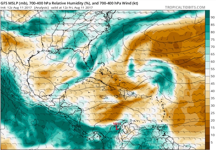
An area of low pressure (99L) located about 200 miles north of the northern Lesser Antilles Islands at 8 am EDT Friday was headed west-northwest to northwest at about 10 mph. Satellite images on Friday morning showed that 99L had only a sparse amount of heavy thunderstorm activity, but a modest degree of spin. The atmosphere surrounding the disturbance was dry, with a mid-level relative humidity around 50%. This dry air was the primary impediment to development, since sea surface temperatures were warm, at 29°C (84°F), and wind shear was moderate, 10 – 20 knots.
The 12Z Friday run of the SHIPS model predicted that wind shear would drop to the low range, less than 10 knots, on Friday afternoon through Saturday night, which should allow the storm to increase in organization--though the surrounding atmosphere will remain dry. On Sunday and Monday, though, wind shear is predicted to rise to a high 20 - 25 knots, which will make further development difficult. Sea surface temperatures will remain around 29°C (84°F).
 |
| Figure 1. The area of moisture associated with 99L, located northeast of Puerto Rico, was surrounded by drier air on Friday morning, August 11. This map shows the starting-point analysis in the GFS model at 12Z (8:00 am EDT) Friday. Green and brown colors (legend at right) show relative humidity in the layer between 700 and 400 mb, or between about 10,000 and 24,000 feet. Average winds through the same layer are shown by wind flags and barbs. Image credit: tropicaltidbits.com. |
Model support for development of 99L is lukewarm. The 0Z Friday European model ensemble forecast had 38% of its members bringing 99L to tropical storm status early next week, and the UKMET model showed some limited development of 99L early next week. However, our other model for predicting tropical cyclone genesis, the GFS, did not show development of 99L in its 0Z and 06Z Friday runs.
If it does manage to develop, 99L is not expected to directly threaten any land areas. A trough of low pressure pushing off the U.S. East Coast will pull 99L to the north and then northeast, with the storm passing between North Carolina and Bermuda, then well south of the Canadian Maritime Provinces. In its 8 am Friday tropical weather outlook, the National Hurricane Center gave 99L a 30% chance of developing into at least a tropical depression by Sunday morning, and a 50% chance by Wednesday morning. The next name on the Atlantic list of storms is Gert.
Franklin’s remains regenerating over the Pacific
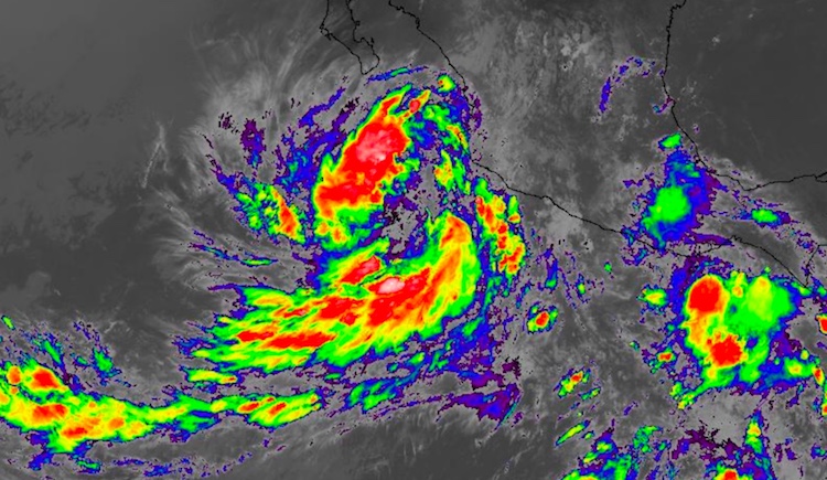
Satellite images on Friday morning showed that the remains of Hurricane Franklin, which hit the Veracruz state of Mexico early Thursday morning, were over the Pacific Ocean over 500 miles south-southeast of the tip of the Baja Peninsula. The disturbance, dubbed 92E by NHC, was well-organized, with plenty of spin and heavy thunderstorms. In their 8 am Friday tropical weather outlook, the National Hurricane Center gave the remains of Franklin a 90% chance of developing into a tropical depression by Sunday. The storm is expected to move west-northwest, passing several hundred miles south of the southern tip of Mexico’s Baja Peninsula. Since Franklin did not survive the crossing of Mexico as an identifiable tropical cyclone, the new storm would get a new Eastern Pacific name. The next named storm in the list is Jova. Any potential Tropical Storm Jova will encounter a less conducive atmosphere for development by Monday, and it is unlikely that we will see a Hurricane Jova.
 |
| Figure 2. Infrared satellite image of the remnants of Hurricane Franklin reorganizing in the northeast Pacific off the Mexican coast at 1600Z (noon EDT) Friday, August 11, 2017. Image credit: NASA/MSFC Earth Science Branch. |
Elsewhere in the tropics
A weak and elongated area of low pressure just off the east coast of Florida on Friday morning was accompanied by disorganized showers and thunderstorms extending from southern Florida northeastward across the southwestern Atlantic. Dry air and high wind shear of 30 knots are expected to keep this system from developing, but it could still produce locally heavy rains to portions of the Florida peninsula as it moves northward during the weekend. In its 8 am Friday tropical weather outlook, the National Hurricane Center gave the system 2-day and 5-day odds of development of 10%.
A new tropical wave expected to come off the coast of Africa on Sunday will bear watching as we approach the peak of the Cape Verde season, when the Main Development Region (MDR) between Africa and the Lesser Antilles is at its most active. However, this wave had lower model support for development on Friday morning compared to Thursday morning—less than 10% of the 70 members of the European and GFS model ensembles predicted development in their 0Z Friday runs, compared to 20 – 30% predicting development in their 0Z Thursday forecasts. The wave will head west to west-northwest across the MDR on a track that could end up similar to 99L’s, passing near or a few hundred miles north of the northern Lesser Antilles Islands about a week after emerging from Africa.
The Madden-Julian Oscillation should be in a mode that favors development in the Atlantic during mid- to late August, based on the latest NOAA forecasts of rising and sinking air at upper levels.
What are you doing for the 2017 total eclipse?
What are your plans for Monday, August 21? If you live in the contiguous U.S., you'll get at least a partial eclipse, and millions of Americans along a narrow path stretching from Oregon to South Carolina will get the rare chance to experience a total eclipse. Today we're launching an open-thread post on the eclipse, where you can share your plans, hopes, and fears (of cloud cover, for instance!). The URL for that post will appear here in a few minutes. We encourage you to keep the Disqus comments on that post centered on the eclipse, with your tropical-weather-related commentary confined to the latest post on the tropics. We'll be back with a new tropical update over the weekend.
Jeff Masters co-wrote this post.


