At the center of a compact severe weather threat area highlighted by the NOAA/NWS Storm Prediction Center for Sunday, March 27, as of 11:30 am CDT was a moderate risk across parts of south-central Oklahoma and far north Texas (red). “Moderate” is the second-highest of the risk ratings issued by SPC.
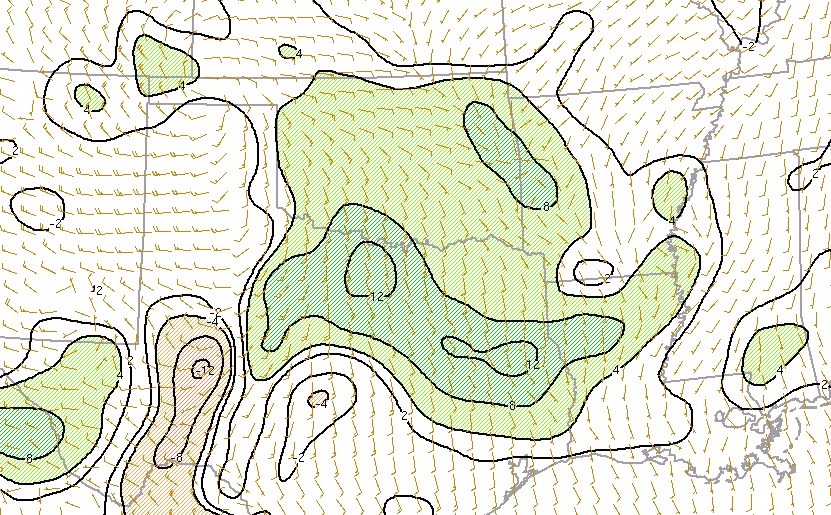
A couple of intense supercells, possibly bearing tornadoes, may crop up late Sunday in south central Oklahoma, possibly extending into north central Texas. Low-level moisture was quite limited across the area late Sunday morning, with dewpoints mainly between 50°F and 55°F. However, dewpoints in the low- to mid-60s had surged from the Gulf of Mexico to just south of the Dallas-Fort Worth area. As a compact upper-level low swings into the Southern Plains, a surface low centered near the Oklahoma Panhandle on Sunday morning will quickly strengthen, with a sharp dryline and cold front extending southward.
Moisture streaming northward from the Gulf is not quite as deep as it can be this time of year, but it appears richer than it did with Friday’s limited severe weather. If deep moisture does make its way as far north as the corridor between DFW and Oklahoma City, conditions there will be quite favorable for tornadic storms, with substantial instability (perhaps up to 2000 joules per kilogram of CAPE) and ample wind shear (winds will be veering as well as strengthening with height).
 |
| A midlatitude storm wrapping up over the Southern Plains is arriving hard on the heels of another midlatitude storm now centered in northern Illinois, as shown here in a NOAA GOES-16 visible image from 10:52 am CDT Sunday, March 27, 2017. The short distance between these systems has made it difficult for moisture from the Gulf of Mexico to return in time for today’s potential severe weather in OK/TX. Data from GOES-16 are preliminary, undergoing testing, and have not yet been declared operational. Image credit: College of DuPage. |
Although low-level wind shear will not be exceptionally strong, the distinct veering (turning of winds with height) should help lead to well-structured supercells. I wouldn’t expect a widespread tornado outbreak, but the situation definitely bears watching in and near the Interstate 35 corridor between DFW and OKC, especially between about 4:00 and 9:00 pm CDT Sunday.
 |
| Dewpoint changes between 8:00 and 11:00 am CDT Sunday, March 26, 2017 (increases in green, decreases in tan) atop surface winds at 11:00 am. Dewpoints increased more than 12°F in three hours across parts of north Texas as a surge of moisture arrived from the Gulf of Mexico. Image credit: NOAA/NWS Storm Prediction Center. |
The NOAA/NWS Storm Prediction Center raised the risk level in this area from enhanced to moderate early Sunday morning, highlighting the chance of tornadoes, significant large hail (larger than 2” in diameter) and very high wind (gusts of at least 74 mph). Short-range computer models indicate that the storms may congeal into a squall line on Sunday from eastern Oklahoma into western Arkansas. Thunderstorms should be somewhat less severe but more widespread across northern Oklahoma and much of Kansas.


