| Above: The National Hurricane Center is located on the campus of Florida International University in western Miami, collocated with the National Weather Service forecast office for the Miami-South Florida area. Image credit: NOAA. |
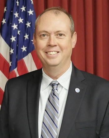
NOAA announced on Thursday that Kenneth Graham, meteorologist-in-charge of the New Orleans/Baton Rouge office of the National Weather Service (NWS), will be the next director of the NOAA/NWS National Hurricane Center (NHC). Graham will take his new post on April 1, succeeding acting director Ed Rappaport.
Graham has deep roots in the Gulf Coast states. He joined NOAA in 1994 after working as a broadcast meteorologist at WCBI (Columbus, MS). Before moving to the New Orleans area, he served as meteorologist-in-charge at the NWS offices in Birmingham, AL, and Corpus Christi, TX, and headed the systems operations division of the NWS Southern Region in Fort Worth, TX, where he led the agency’s recovery efforts following Hurricane Katrina.
 |
| Figure 1. Ken Graham. Image credit: NOAA/NWS. |
While stationed in the New Orleans area, Graham led the effort to provide innovative meteorological support for two command centers following the 2010 Deepwater Horizon oil spill in the Gulf of Mexico, helping authorities to make crucial decisions in the months following the spill. During Graham’s tenure at NWS New Orleans/Baton Rouge, the office developed SWERV (Significant Weather Emergency Response Vehicle)—the NWS’s first mobile command incident response vehicle—as part of a pilot project for the Weather-Ready Nation initiative.
"Ken Graham has done a wonderful job serving those of us along the central Gulf Coast,” said Jim Waskom, executive director of the Louisiana Governor’s Office of Homeland Security & Emergency Preparedness, in an email. “His passion for his job is second to none. Ken is always available to discuss and explain sometimes highly technical weather information needed to make critical emergency management decisions. While we are losing a great resource here in the state, everyone will benefit having Ken in his new role at the hurricane center. We look forward to working with him more in the future."
Previous directors of the National Hurricane Center
Most NHC directors have served for around three to seven years. The longest tenure in recent decades was that of Neil Frank, who led the agency for 14 seasons. The shortest, a turbulent six months, was that of Bill Proenza. Rick Knabb, who headed NHC from 2012 through 2017, is now the on-air hurricane expert and tropical program manager at The Weather Channel, where he also served from 2010 to 2012.
The primary U.S. Weather Bureau office for hurricane prediction was moved from Jacksonville to Miami in 1943, with Grady Norton at the helm until he died while working during Hurricane Hazel in 1954. Since the center's official establishment as NHC in 1955, its directors have included:
Gordon Dunn: 1955–1967
Robert Simpson: 1967-1973
Neil Frank: 1974–1987
Bob Sheets: 1988-1994
Bob Burpee: 1995–1996
Jerry Jarrell: 1996–2000
Max Mayfield: 2000–2006
Bill Proenza: 2007
Bill Read: 2008–2012
Rick Knabb: 2012–2017
Some NHC directors have had to deal with more hurricane action than others, thanks in large part to the prolonged drop in activity from the late 1960s through the early 1990s and the more active era since the mid-1990s. For example, during the 14 seasons when Neil Frank was director, there were 71 hurricanes in the Atlantic basin, 24 of those majors (Category 3 or stronger). A similar amount of Atlantic activity was packed into the six seasons of Max Mayfield’s directorship: 57 hurricanes and 27 majors.
The biggest physical threat to the center itself came during Bob Sheets’ tenure with the arrival in 1992 of catastrophic Category 5 Hurricane Andrew, which struck just south of Miami. At that time, NHC was based in Coral Gables, near the campus of the University of Miami. As it passed just to the south of NHC, Andrew brought 164-mph wind gusts to the center and destroyed the rooftop radar, sending part of the radome crashing onto the pickup truck of an NHC employee. Three years after Andrew, NHC was relocated to its current location and building, which is hardened to withstand Category 5 winds. NHC public affairs officer Dennis Feltgen has an excellent first-person summary of the center's encounter with Andrew.
 |
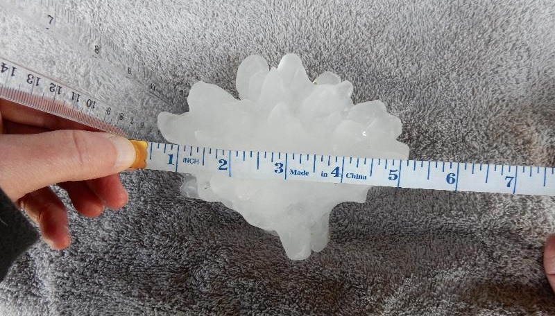
| Figure 2. A massive hailstone that fell in Cullman, AL, on Monday, March 19, 2018, measured 5.25” in peak width, with a circumference of 13.75” and a weight of 8.9 ounces. It appears this is the largest hailstone ever recorded in Alabama, though a final determination will be made by NOAA’s National Centers for Environmental Information. The nation’s widest and heaviest hailstone on record, which fell in 2010 in Vivian, South Dakota, measured 8.0” in diameter, 18.62” in circumference, and 1.93 pounds. The largest circumference on record is 18.75", from a hailstone that fell in 2003 in Aurora, Nebraska. Image credit: NWS/Huntsville, AL. |
Wild week behind us: A quick recap of the week’s big U.S. weather events
Severe weather in the South: A localized but intense outbreak of severe weather hammered the South on Monday and Tuesday. Grapefruit-sized hail pummeled Alabama, including a hailstone 5.25” in diameter that could end up being confirmed as the largest hailstone in Alabama history (see Figure 2 above).
Among the 23 tornadoes reported on Monday, the worst was an EF3 that swept through Jacksonville, AL, including the campus of Jacksonville State University. Fortunately, it was spring break at JSU, and there were only two injuries in Jacksonville. Still, the mayhem was widespread, including many uprooted trees and some structural damage. This was the nation’s first F3/EF3 tornado in 306 days—the longest such “drought” in NOAA records dating back to the 1950s, according to Steve Bowen (Aon Benfield).
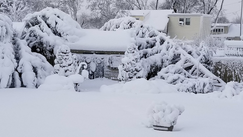
Spring nor’easter: A swath of mostly wet, fast-falling snow swept across the Midwest and up the East Coast from Tuesday night through Wednesday night. Amounts in the big cities of the Northeast fell short of major records—and well below expectations in some cases, with just 1.3” in Boston—but New York’s Central Park saw 8.2” and Philadelphia notched 7.6”, with 14.2” at the Pennsylvania capital of Harrisburg. Central Long Island hit the jackpot: 20.1” was reported by an NWS employee in Patchogue, and 18.4” fell at Islip’s Long Island MacArthur Airport, including an amazing 9” in just two hours.
 |
| Figure 3. More than a foot of snow in central Long Island split this cypress tree in two in Babylon, NY, on Wednesday night, March 21, 2018. Image credit: Teri Willis. |
 |
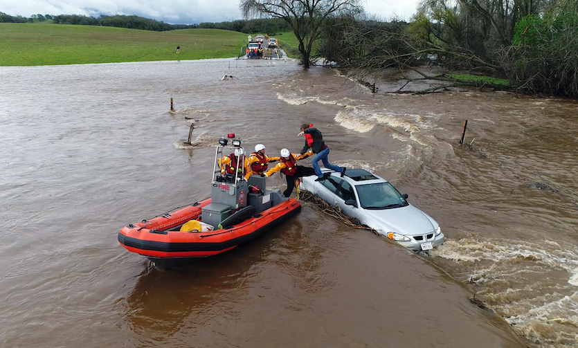
| Figure 4. This drone photo from video provided by the California Governor's Office of Emergency Services shows firefighters from the Folsom Fire Department rescuing a motorist whose car became stuck as a flash flood washed over a road near Folsom on Thursday, March 22, 2018. Image credit: Kelly B. Huston/California Governor's Office of Emergency Services via AP. |
Atmospheric river in California: Coastal Southern California escaped without major flash flooding from the widespread spring storm that brought heavy rain and high-altitude snow across California from Tuesday through Thursday. A few water rescues were reported, and there were widespread mudflows and some road damage, but the storm turned out to be good news for water resources in moisture-starved California. The state saw well-below-average precipitation from October through February, which was the sixth driest such period in 123 years of recordkeeping.
For more on each of these events, see weather.com’s comprehensive summaries of the Southern severe weather, Winter Storm Toby, and the California storm.
Daylight images of the The Reserve apartment complex in Jacksonville, Alabama. #jacksonville pic.twitter.com/GPsn7tNxw8
— MikeDubberlyGDA (@MikeDubberlyGDA) March 20, 2018


