| Above: Flooded homes are shown near Lake Houston following Hurricane Harvey on Wednesday, August 30, 2017. Image credit: Photo by Win McNamee/Getty Images. |
Former Hurricane Harvey worked its way up the Mississippi Valley on Thursday as a tropical depression, still dumping torrential rain but moving quickly enough to avoid further disaster. Advisories on Harvey are now being issued by the NOAA/NWS Weather Prediction Center, which placed Harvey at 10 am CDT Thursday about 35 miles east of Monroe, Louisiana. Top sustained winds were a mere 20 mph, and Harvey was moving northeast at about 10 mph. That’s not exactly speed-demon territory, but it’s far better than the 2- to 5-mph pace during much of Harvey’s time in Texas.
Almost a week after Harvey made landfall in Texas, the state has barely had a chance to start a recovery process that will no doubt take years. Harvey has taken a toll along the entire coastal region from Corpus Christi to Port Arthur, with more than 10 million people directly affected. Rescues were still under way in far southeast Texas on Thursday, and there was not yet an accurate count of how many people might have died or may still need rescuing, though the most recent death toll of 39 is expected to rise. Door-to-door searches were under way in Houston, while multiple explosions rocked a chemical plant disabled by power loss and generator failures in Crosby, northeast of Houston.
Flooding was also massive and severe in the Beaumont-Port Arthur area of far southeast Texas, where Harvey delivered more than 20” of rain on Tuesday night. From Friday through Wednesday, the Beaumont airport racked up a stunning 47.47” of rain. Its monthly total of 54.73” has already demolished the previous record of 26.31” (October 1970), and the annual total of 89.59” has already beaten 1949’s record of 87.40”—with four months of the year left to go. In a cruelly ironic twist, the waterlogged city entered its second day on Thursday with no running water.
 |
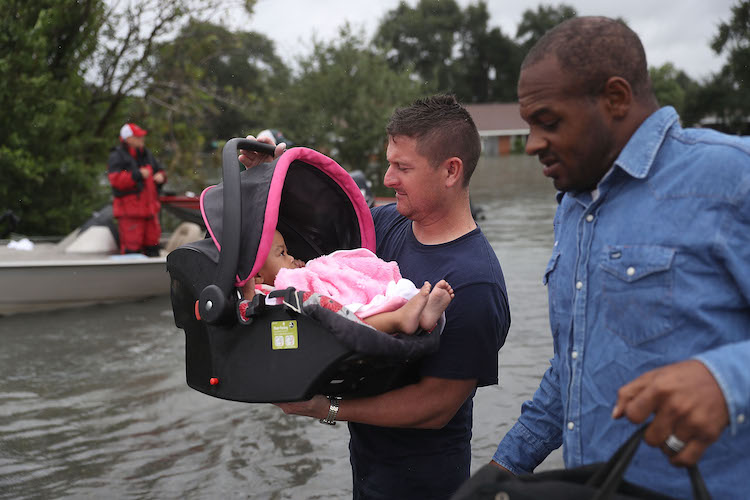
| Figure 1. A rescue worker carries a baby to dry land after she was rescued from the flooding of Hurricane Harvey on Wednesday, August 30, 2017 in Port Arthur, TX. Image credit: Photo by Joe Raedle/Getty Images |
 |
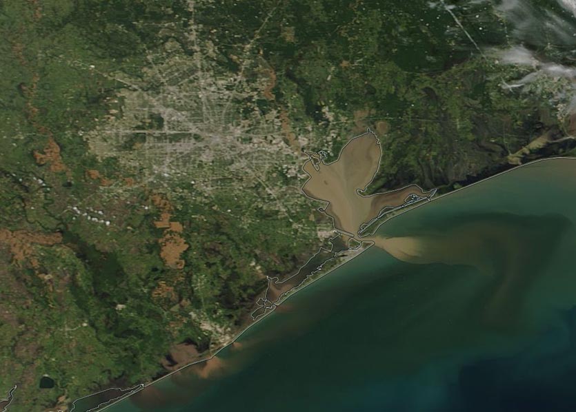
| Figure 2. MODIS image from NASA’s Terra satellite on August 31, 2017, showing flooding in the Houston, Texas area and sediment plumes in the Gulf of Mexico from Hurricane Harvey. Image credit: NASA. |
Flooding began to subside in many parts of southeast Texas and Louisiana on Thursday, but the waters remained high in other areas where levees were breached or reservoir spillways were overtopped. Some 3000 homes have been flooded behind Addicks Reservoir, with about 1000 flooded behind adjacent Barker Reservoir; these homes may stay inundated for a month or longer. As of midday Thursday, the water height at Barker and Addicks Reservoirs was holding close to all-time highs reached on Tuesday, and no further rises were expected for the time being.
Here are the highest storm totals for Harvey in each state as of 10 am CDT Thursday.
Alabama: 8.00”, Gasque
Arkansas: 6.42”, Mammoth Springs (2 mi SSE)
Florida: 6.92”, Milton
Louisiana: 22.25”, Bayou Conway
Mississippi: 6.27”, Gautier
Texas: 51.88”, Cedar Bayou at FM 1942
The 51.88” at Cedar Bayou is the new all-time record storm total for any tropical cyclone in the continental U.S., beating 48” from 1978’s Tropical Storm Amelia and falling only 0.12” short of the U.S. record of 52” from Hawaii’s Hurricane Hiki. Some personal weather stations recorded even higher totals, although any of those would need to be from reliable instruments and verified in post-storm surveys in order to enter the official database. Our Tuesday post detailed many of the rainfall records smashed by Harvey in Houston.
 |
| Figure 3. Total precipitation from Hurricane Harvey as of 6 am CDT August 30, 2017. Additional precipitation fell in regions on the right side of this image after this map was made. Image credit: NWS. |
 |
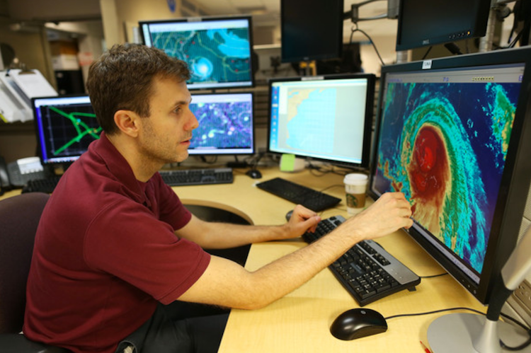
| Figure 4. NHC hurricane specialist Eric Blake tracks Hurricane Joaquin over the Bahamas on October 1, 2015. On Thursday morning, Blake upgraded Tropical Storm Irma to a Category 2 hurricane and predicted it would become a Category 4 storm in 120 hours. Image credit: Joe Raedle/Getty Images. |
Preparing us for Harvey: Credit where credit is due
The National Hurricane Center included this note in its final discussion on Harvey, issued Wednesday night: “The National Hurricane Center would like to thank all the men and women that have worked countless hours at local National Weather Service Forecast offices along the Gulf coast providing life-saving warnings and information during the past week, on top of preparing their family and homes for the storm. The center would also like to acknowledge the dedication of the Air Force and NOAA Hurricane Hunter aircraft crews that flew numerous missions into Harvey. In addition, NHC thanks the staff at the Weather Prediction Center, who led efforts to coordinate forecasts of the historic flooding event, NWS River Forecast Centers that provided flood guidance, and the Storm Prediction Center, that coordinated tornado forecasts.”
We’d like to add a big hurrah for the dedicated staff at NHC itself. They kept a steady hand on the wheel while keeping the public abreast of a storm with impacts that were extreme, multifaceted, and in some cases unprecedented. Major credit also goes to the many weathercasters who put in long hours getting the word out in clear, easy-to-understand words and graphics—as well as to the scientists and software engineers who develop the computer forecast models that we all rely on. The tools created by these unsung heroes gave us the first inkling that truly massive rains were in store from Harvey, and the newer short-range models did a phenomenal job with calling the peak rainfall over Houston last weekend.
Americans are lucky to have a weather enterprise with three robust wings: public agencies and labs, private firms, and university researchers. For all the issues that this catastrophic storm has raised—and there are plenty—it’s worth noting that many things in the build-up to Harvey went right.
Busy times continue in the tropical Atlantic
It’s now been more than two weeks since we first wrote about a tropical wave in the Eastern Atlantic called 91L that ended up becoming Harvey. That same broad zone of disturbed weather also gave birth to 92L, which eventually led to short-lived Potential Tropical Cyclone 10 off the U.S. East Coast. And right behind 91L over western Africa, an intense cluster of thunderstorms triggered the flash floods and mudslides in Sierra Leone on August 14, which killed at least 499 people and likely hundreds more.
All of these events bear witness to this summer’s very active train of atmospheric waves streaming across Africa and into the Atlantic—one that shows little sign of slowing anytime soon. See our post from Thursday morning on rapidly intensifying Hurricane Irma.
Jeff Masters contributed to this post.


