| Above: Scorching temperatures affected much of the eastern Mediterranean on Saturday, May 13, 2017. Shown here in degrees C are readings analyzed for 1200Z Saturday (3 PM local time in Athens, Greece). Image credit: tropicaltidbits.com. |
A burst of desert air swept from northern Africa into southeast Europe over the weekend, bringing temperatures more akin to August than May. Readings above 35°C (95°F) were widespread across Greece on Saturday. The city of Argos (one of the world’s oldest) reported a high of 40.6°C (105.1°F), which ties a 40.6°C reading set in nearby Astros in May 1988 for the warmest May temperature on record for Greece. The Athens airport notched its highest temperature ever recorded so early in the year: 33.4°C (92.1°F) on Saturday, beating 32.6°C from May 13, 2007.
 |
| Figure 1. High temperatures across Greece on Saturday, May 13, 2017. Image credit: Etienne Kapikian, Greece National Observatory, Athens. |
Monthly records are especially impressive when they manage to occur toward the front end of a transition-season month such as May. Friday was one of the hottest days ever recorded in northern Africa for the first half of May, said international weather records expert Maximiliano Herrera. A high of 47.0°C (116.6°F) was reported in Zuara, Libya, where the all-time national high is 45.7°C for April and 49.9°F for May. Tripoli’s airport officially hit 45.0°C (113°F), and nearby personal weather stations reported highs close to 48°C (118°F).
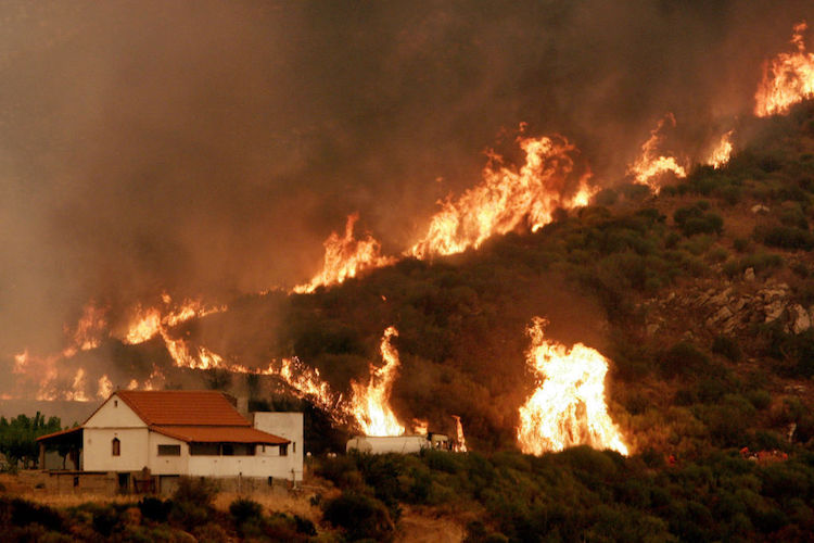
A localized but intense forest fire killed one person and injured two others on Sunday near the town of Agioi Theodoroi, about 40 miles west of Athens. According to Reuters, several dozen firefighters with 32 fire engines and six aircraft battled the flames, which had died down by early evening. Forest fires are a perennial threat during the hot, dry Greek summer, but such fires are quite unusual in mid-spring. The summer of 2007 was marked by horrific fires in Greece (see Figure 2) that peaked in August during severe heat and drought. Some 670,000 acres were scorched and 84 people were killed by the fires that summer.
 |
| Figure 2. A fire threatening the church of Zoodohos Pygi near the village of Andritsena on Greece’s Peloponnese peninsula on Aug. 27, 2007. Image credit: Aris Messinis/AFP/Getty Images. |
 |
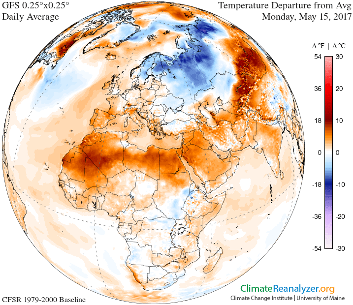
| Figure 3. Temperatures were expected to be well above average (orange) from northern Africa and southwest Europe to the Middle East and central Asia on Monday, May 15, 2017. Image credit: Climate Reanalyzer/University of Maine. |
Negative NAO helping to stoke the Mediterranean warmth
Temperatures dropped to more tolerable values across Greece on Monday, but very warm conditions were surging into southwest Europe, with temperature already soaring above 30°C (86°F) in parts of southern France on Monday.
The Weather Company’s European outlook for May, issued in late April, predicted that warmer-than-average conditions would prevail across southern Europe and parts of central Asia. One of the main factors playing into the outlook was expectations of a negative North Atlantic Oscillation (NAO), according to TWC chief meteorologist Todd Crawford. During May, a negative NAO tends to keep northern Europe cool while allowing parts of the Mediterranean to warm above average. Last week Norway saw its heaviest May snowfalls since 1967, according to Herrera. Accumulations in Oslo ranged from 5 cm (2 inches) near the city center to as much as 40 cm (16 in.) in some outskirt areas.
 |
| Figure 4. NAO values during meteorological summer (June-August) since 1950. Although the summertime NAO tends to vary from from year to year, only one of the last 10 summers has seen a predominantly positive NAO. Image credit: Todd Crawford, The Weather Company. |
If the last decade is any indication, negative NAO values may persist through much of the upcoming summer. “There has been a rather remarkable change in the summer climate over the last decade, where the summer pattern has been characterized by sharply negative NAO patterns every year since 2007, with the exception of 2013,” said Crawford (see Figure 3). He believes the unusually low spring extent of sea ice in the Arctic since 2007 has been a factor in the low spring/summer NAO values. Another factor is the cold pool that’s persisted in the Atlantic just south of Greenland for the last several years, likely fed by melting sea ice as well as the recent tendency for a positive NAO during winter.


