| Above: WU depiction of NOAA/SPC severe weather outlook for Monday, June 12, 2017, valid through early Tuesday morning. The red area corresponds to a moderate risk, the second-highest of SPC's five risk categories. Surrounding the moderate risk is an enhanced-risk area (orange) and a broad slight-risk area (yellow). |
Tornado Alley may take a brief jog to the west on Monday afternoon, as a strong upper-level system is set to trigger potentially tornadic storms over parts of eastern Wyoming and western Nebraska. The peak twister risk should only run a few hours before storms congeal into a larger complex, but during that span there could be one or more supercells. “Strong tornadoes are possible today,” noted the NOAA/NWS Storm Prediction Center in its 11:30 am CDT update.
Other severe storms may occur Monday along a warm front extending east from Nebraska and South Dakota, with a separate pocket of severe weather potential over northern Maine.
The High Plains severe weather will be triggered by an especially strong clash between warm, moist surface air pushing in from the Gulf of Mexico and very cold air aloft sweeping east over the area from the Pacific Northwest. Vertical wind shear will be especially favorable over eastern Wyoming, and the cold air aloft together with relatively moist air at the surface means there should be ample instability even though surface temperatures won’t be especially warm (not much beyond about 80°F at best).
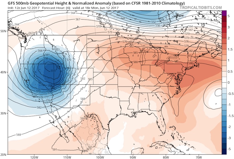 |
| Figure 1. Height of the 500-millibar surface (the rough midpoint of the atmosphere, about 19,000 feet above sea level) at 8:00 am EDT Monday, June 12, 2017. Dark blue colors in the upper low moving through the western U.S. show that the 500-millibar heights are up to 3 standard deviations below average. The 500-millibar heights are shown in decameters, or tens of meters. Image credit: tropicaltidbits.com. |
The cold air aloft is associated with an upper-level low that’s quite strong for June—strong enough to produce snow in California’s Sierra Nevada early Monday (see Figure 2). As the upper low continues east, snow may overspread large parts of Yellowstone and Grand Teton National Parks on Monday night, with totals of more than foot in the higher elevations. High winds are accompanying the storm across the northern and central Rockies: a gust to 73 mph was reported Monday morning on the Oquirrh Mountains just west of Salt Lake City.
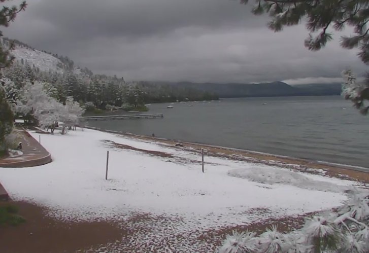 |
| Figure 2. A banner year for snowfall in the Sierra Nevada was capped off by a few additional inches in the predawn hours on Monday, June 12, 2017. Snow levels dipped as low as Lake Tahoe, on the California/Nevada border. Measurable snow falls at lake level in June only about once every 5 to 10 years. Image credit: NWS Reno. |
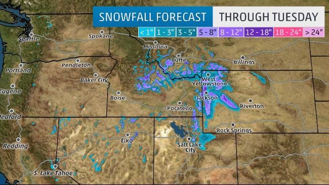 |
| Figure 3. Snowfall outlook through Tuesday. Image credit: weather.com. |
As the upper low continues into the northern Great Plains on Tuesday and a cold front and dryline east, a more widespread round of significant severe weather is expected, particularly along a corridor from eastern NE/SD/ND to MN/IA. The cold air aloft will be sweeping across an increasingly sultry air mass, so instability could reach extreme levels, and wind shear will be strong enough to support tornadic storms. Severe weather could extend all the way down the front and dryline as far as Texas, which would be an unusual north-to-south extent for mid-June.
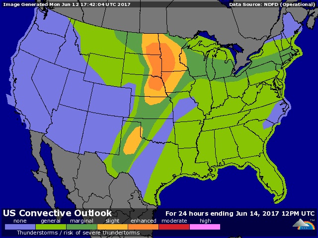 |
| Figure 4. WU depiction of NOAA/SPC severe weather outlook issued at 12:30 pm CDT Monday, June 12, and valid for Tuesday into early Wednesday, June 13-14, 2017. |
Tornadoes at elevation
Wyoming is not the first state that comes to mind when people think about U.S. tornadoes, but they do occur there. One person was killed and 37 injured when an F3 twister moved through parts of Cheyenne on July 19, 1979 (see this vintage compilation of film and video of the event). The Cheyenne tornado destroyed an estimated 200 homes, making it the most damaging tornado in state history when it comes to built structures. As for forest damage, an estimated one million trees were uprooted by the state's strongest tornado on record--an F4 that struck on July 21, 1987, in the Teton-Yellowstone area. This twister is the highest-elevation violent tornado on record in the United States by far. It affected elevations between 8500 and 10,000 feet and actually crossed the Continental Divide.
Oddly enough, the best-observed and most-analyzed tornado of the entire two-year VORTEX2 field project (2009-2010) occurred not in the long-planned study area of the southern and central Great Plains, but instead over far southeast Wyoming on June 5, 2009, where an EF2 tornado struck about 50 miles northeast of Cheyenne near the Nebraska border (see Figure 4).
Fortunately, Wyoming is so sparsely populated that the odds of a direct tornadic hit on a city or town are very low.
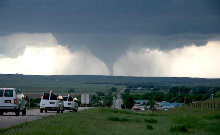 |
| Figure 5. This image shows a tornado from a vantage point along Wyoming SH 151 in Goshen County, several miles east of LaGrange. It was observed on June 5, 2009, during VORTEX2, the second field phase of the Verification of the Origins of Rotation in Tornadoes Experiment. Image credit: Bob Henson, (C) UCAR. |


