| Above. Infrared satellite image of TD 2E south of Mexico as of 11:15 am EDT Wednesday, May 31, 2017. Image credit: NOAA/NESDIS |
A tropical disturbance about 200 miles south of Mexico’s Oaxacan coast has gained enough organization to become Tropical Depression 2E. The National Hurricane Center (NHC) upgraded the disturbance to depression status at 11:00 am EDT and estimated its top sustained winds at 30 mph (see Figure 1). TD 2E was located 250 miles south of Acapulco and was moving northeast at a leisurely 3 mph. If 2E becomes a tropical storm as predicted by NHC, its name will be Beatriz.
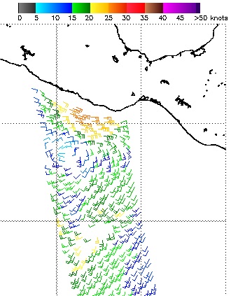 |
| Figure 1. Low-level winds derived from the satellite-borne ASCAT scatterometer early Wednesday, May 31, 2017. Winds were less than 20 knots (23 mph) on the south side of the circulation but stronger than 25 knots (29 mph) on the north side, as depicted by the orange and red flags. Image credit: EUMETSAT, via NOAA. |
The outlook for 2E: Slow-moving and wet
TD 2E is in a quite supportive environment for growth. Vertical wind shear in the vicinity of 2E should remain very low for at least the next day—no more than around 10 knots (12 mph), as suggested by the 12Z Wednesday run of the SHIPS model. Sea-surface temperatures (SSTs) between 2E and the Mexican coast are close to the average for this time of year, a very warm 29-30°C (84-86°F).
We may have to contend with TD 2E for days to come. Upper-level steering currents are very weak, as suggested by the light wind shear and slow movement. That puts a big asterisk on any particular model solution, because small differences in the model-generated wind field could make a big difference in when (or even whether) 2E comes ashore. In its initial discussion on TD 2E, NHC notes the model discrepancies: GFS, NWRF, and the Canadian model all bring TD 2E onshore on Thursday or Friday, but the ECMWF and UKMET models keep the system languishing offshore. Complex interactions between 2E and the rugged topography near the coast—which are difficult for models to capture—throw even more uncertainty into the track forecast.
Despite the favorable conditions for strengthening, TD 2E hasn’t much time to intensify before it nudges close enough to the Mexican coastline for the topography to interfere with development. The 00Z and 06Z Wednesday runs of the HWRF model—our best model for storm intensity in the 1- to 2-day forecast window—intensify 2E into a higher-end tropical storm before a projected landfall west of Puerto Angel on Thursday afternoon, with top winds of 55-60 knots (62-70 mph). If 2E takes longer to approach the coast, it would have time to strengthen further, although a very slow motion would also churn up cooler water that could dent its strength.
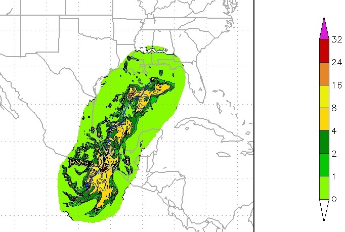 |
| Figure 2. Rainfall generated along 2E’s track by the 06Z Wednesday run of the HWRF model. Rainfall depicted over the Gulf of Mexico is based on the HWRF forecast that 2E will make it into the western Gulf as an identifiable system, but there is still considerable model disagreement on 2E’s future. Image credit: NOAA/NCEP |
The atmosphere surrounding 2E is extremely moist. Relative humidities are close to 80 percent, and precipitable water (the amount of water vapor in a column of air above a given point) is on the order of 2.5 inches on the north and east sides of the depression. This moisture will be pooled and concentrated as 2E approaches the mountainous terrain of southern Mexico. Whether or not 2E makes a prompt landfall, rainfall totals of 8” - 12” are likely along and near the coast. Localized amounts of 20” or more are possible, especially along south-facing hillsides and mountainsides.
The high terrain of southern Mexico should weaken TD 2E greatly if it moves inland. Assuming the storm's remnants continue northward, they could produce heavy rain over the western Gulf of Mexico, as depicted by the 06Z HWRF (see Figure 2 above), and moisture streaming north may help fuel heavy rains along the U.S. Gulf Coast by the weekend. A weak front near the coast could interact with any northward-flowing moisture to help boost rainfall along the central Gulf Coast.
Fortunately, it’s unlikely that any remnants of TD 2E will reorganize in a significant way in the Gulf. Any attempt at a reorganized system would encounter progressively higher wind shear and lower SSTs as it continued north. Still, the system bears watching for its rainmaking potential alone, as emphasized by weather.com’s Jon Erdman.
 |
| Figure 3. Sri Lankan Army personnel distribute food to flood victims in Molkawa in the district of Kalutara on May 30, 2017. Sri Lanka appealed May 30 for volunteers to help with a massive clean-up after landslides and floods left more than 200 dead and tens of thousands without safe drinking water. The government sought help to purify wells contaminated by the floods, the worst in 14 years, after record rainfall in the island's southwest. Image credit: Lakruwan Wanniarachchi/AFP/Getty Images. |
 |
| Figure 4. A Bangladeshi villager evacuates to a cyclone shelter on the coast in Cox's Bazar district on May 30, 2017. Cyclone Mora hit Bangladesh on May 30, damaging thousands of homes and forcing more than 300,000 people to flee coastal villages. Image credit: AFP/Getty Images. |
Deadly floods hit Sri Lanka in lead-up to Cyclone Mora
A tropical disturbance that eventually became Cyclone Mora produced havoc from Sri Lanka to Bangladesh over the past week. Very moist southwesterly monsoonal winds at low levels, feeding into the incipient disturbance well northeast of Sri Lanka, slammed against the island’s southern mountains, producing floods over the weekend that killed at least 203 people. According to a summary in the Indian Express from India’s Disaster Management Centre, more than 600,000 people in Sri Lanka were affected and some 9000 homes were damaged or destroyed. Deforestation for agriculture has left denuded hillsides in Sri Lanka prone to fast runoff and rapid flooding
After organizing as a tropical cyclone in the central Bay of Bengal on Sunday, May 28, Mora intensified to the equivalent of minimal Category 1 strength (top 1-minute sustained winds of 75 mph) and made landfall just east of Chittagong at 6:00 am Tuesday local time. A weather.com roundup notes that some 300,000 people were evacuated ahead of Mona, and at least 3 deaths have been reported.
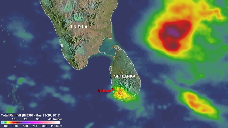 |
| Figure 5. Rainfall for the period May 23-26, 2017, across the southern Bay of Bengal, as estimated by NASA’s Global Precipitation Measurement satellite, a joint mission with the Japanese Meteorological Agency. Widespread 5” – 10” totals are evident across southwestern Sri Lanka. Even heavier totals were measured near the center of the disturbance well to the northeast that evolved into Cyclone Mona. A NASA video shows the rainfall intensifying in both locations toward the end of the period. GPM is a joint mission between NASA and the Japanese space agency JAXA. Image credit: NASA |
 |
| Figure 6. Image from the Himiwari-8 satellite of Cyclone Mora approaching the coast of Bangladesh as a minimal Category 1 hurricane on May 30, 2017. Image credit: SSEC/CIMSS, University of Wisconsin-Madison, via Wikimedia Commons. |
Residents of Sri Lanka and Bangladesh underwent similar travails almost exactly a year ago with Cyclone Roanu in mid-May 2016. During its early stages as a tropical depression, Roanu hugged the northeast coast of Sri Lanka, where its heavy rains produced a landslide that ravaged three villages and caused up to $2 billion US in damage. More than 200 deaths were reported in Sri Lanka. Roanu later struck Bangladesh near Chittagong as a tropical storm, leading to massive evacuation and 26 deaths.


